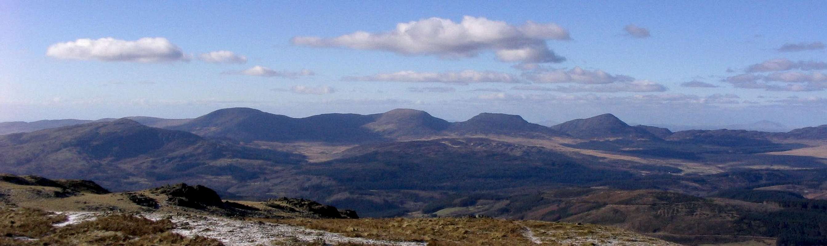
Nestled neatly between the two glacial cwms of Bwlch Tyddiad and Cwm Nantcol rises one of Wales’ most enigmatic but often overlooked little mountains, Rhinog Fawr. Its origins are ancient, being of far greater antiquity than the rocks of the surrounding area. Before the Glyder, Cadair Idris and even Snowdon where thrust up by unremitting tectonic forces, the gritstone rocks of the Rhinogydd stood aloft, and although the natural courses of erosion have now worn them down to mere shadows of their former selves, they remain distinctive and immemorial characters in the Snowdonian landscape.
Along with its southern sister, Rhinog Fach, the mountain lends its name to its home range, the Rhinogydd; but Rhinog Fawr isn’t the highest mountain in the collective, this honour goes to Y Llethr, a little further south again. Despite this, Rhinog Fawr is the better known of the two, and consequently receives more traffic, albeit in Welsh terms, an almost insignificant volume.
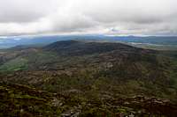
Its slopes, which are often steep, are covered by a thick blanket of heather and rock. Paths and other linear features are few and far between, and anyone wishing to make a visit to the mountain should be a navigator of some competence. Rock climbing, as all things, came late to Rhinog Fawr, and it wasn’t until the final years of the 20th century that any exploration of note took place. Now, for those willing to commit to a long approach, and to accept that finding the right crag might be an endeavour in itself, there’s plenty on offer here. Plenty on offer that is, if the climber is a good one; for the crags and cragletts of the mountain are typically Spartan in character, and do not surrender their treasures as readily as those of the surrounding area.
The weather will play a major role in the success of any trip to the area. For the hiker, poor weather means having to rely heavily on the mountain’s complex and delicate topography for guidance, while for the climber, even a small amount of moisture can erase the rock of friction and render it wholly unscaleable. Timing, therefore, is key to success, and since Rhinog Fawr’s close proximity to the sea means it bears the brunt of the area’s climate, windows of opportunity are often frustratingly brief. A well timed expedition however, can reap some truly wondrous rewards.
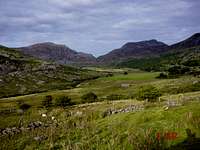
The route starts on the western side of the Rhinogydd at the Cwm Bychan car park (SH 644 313) and follows Bwlch Tyddiad and The Roman Steps up to Llyn Du, gradually gaining around 360 metres in altitude. From here the summit can be reached, either by circumventing the crags below the summit, or by a quick scramble up a short gully, to a broad terrace at around 600 metres, and then up a steep braided path to the top.
The route starts on the eastern side of the Rhinogydd at the Graig Ddi-Isaf car park (SH 680 300), and weaves its way through a coniferous forest to the fore-slopes of the mountain and Bwlch Tyddiad. It then makes its way up a boggy path to Llyn Du, where it joins the previously described route on its way to the summit.
This is Rhinog Fawr’s only lengthy scramble, and begins at the narrowest point of Bwlch Drws Ardudwy. It ascends weaknesses in three tiers of short, steep crags, before reaching a wide, level, slabby ridge. It then ascends a series of broken crags, slabs and boulders to the Rhinog Fawr’s fore-summit, where the scrambling ends, and the true summit is just a short walk away.
The climbing at Rhinog Fawr are split between a number of small, compact buttress which litter the northern and north-western slopes of the mountain.
Unless otherwise stated, routes are listed from left to right, and are graded and rated with the aid of the Climbers' Club Guide to Meirionnydd, so for full descriptions, please refer to this source. Technical grades are generally only given to climbs graded adjectivally as Hard Severe (HS) or above.
Please be aware that Rhinog Fawr is a trad climbing venue and bolting is strictly prohibited. Routes are rated using the British Adjectival Grading System. A conversion table of international climbing grades by SP member Corax is available HERE!
Route Symbols:
A so-so route, neither good nor bad. Not unpleasant unless otherwise stated.
A good route which is definitely worth a climb.
A very good route, one of the best on the crag and well worthy of attention.
An excellent route, one of the best in the area, and probably in Britain too.
No Restrictions
Used to indicate that there are currently no restrictions, either seasonal, temporary or permanent, affecting a route.
Restrictions
Used to indicate that there are restrictions, either seasonal, temporary or permanent, affecting a route. See the Red Tape and Access Section for more details.
Sectret Bay
A hidden gem – impossible to find from the west but obvious from the mountain's eastern approach. Stick this grid reference in your GPS for a hassle free (well perhaps not quite) location – SH 662 294.
No.
Name
Length
Pitches
Adjectival
Grade
Technical
Grade
Quality
Restrictions
1.
Strong Heather
9m
1
VS
4a
2.
A Tomb with a View
9m
1
E2
5b
3.
Esoterica Hysterica
9m
1
E1
5a
Min Pistyll
A pleasantly situated and surprisingly easily located crag (SH 660 294) in the little valley that spills forth from Llyn Du.
The slabs and crags above Llyn Du (SH 657 292). They are split into a Lower and an Upper Bank, with Bebop to Splinter being on the lower one and Fear Test to Disco Bugs on the Upper one. Routes are described from right to left.
No.
Name
Length
Pitches
Adjectival
Grade
Technical
Grade
Quality
Restrictions
26.
Bebop
28m
1
E2
5b
27.
Rock Steady
28m
1
E3
5c
28.
Mist on the Mountain
40m
1
HVS
5a
29.
The First Grassfield
20m
1
E2
5c
30.
The Bridge That Jonathan Built
40m
1
E2
5b
31.
Foreign Object
25m
1
E3
5c
32.
Splinter
18m
1
E1
5b
33.
Fear Test
18m
1
E5
6a
34.
Weeping Wall
15m
1
E2
5b
35.
For the Record
9m
1
E1
5a
36.
TLC
15m
1
E3
5b
37.
Peace in Mind
15m
1
E3
5b
38.
Quartz Storm
15m
1
E3
5b
39.
The Collectors' Pot
25m
1
E1
5b
40.
Dead Sea Scroll
37m
2
E4
5a, 6a
41.
Don's Cairn
30m
1
E2
5c
42.
Disco Bugs
30m
1
E1
5a/b
Uwch y Llyn
Behind the western end of Llyn Du, a little way up Rhinog Fawr's slopes, is a 15 m high crag with twin arêtes (SH 655 293).
Rhinog Fawr can be climbed at anytime of the year however in poor conditions the mountain's rock routes are best avoided, particularly if the weather has been wet. March to April offer the most reliable conditions. Of course this all depends on ones ability as a mountaineer/climber, and what might be comfortable for some may seem daunting for others.
If your lucky enough to climb the mountain in winter conditions then an ice axe and crampons are essential.
Getting There
The Cwm Bychan (SH 644 313) and Maes-Garnedd (SH 641 269) car parks can be reached easily from the A496, which runs along the coast from Llanulltyd near Dolgellau in the south, to Blaenau Ffestiniog in the north.
There is also parking available at Graigddu-Isaf (SH 680 300) on the eastern side of the mountains, which can be reached after from the junction (SH 711 307) just south of Bronaber on the A470.
The area can also be reached by rail, however getting from the stations to the mountains themselves can be difficult as public transport is pretty infrequent and hitch hiking can be a nightmare.
For climbers, hill walkers and mountaineers, the British Mountaineering Council (BMC) runs a Regional Access Database, which holds mountain/crag specific information on matters of conservation and access, including issues such as nesting restrictions, nature designations and preferred parking.
If you are in any doubt about any particular access arrangement, or need to report an incident, you should contact your local BMC Access Representative or the BMC Access Officers for Wales: Elfyn Jones.
Camping and Accommodation
There’s an almost unlimited supply of accommodation within the Snowdonia National Park so it would be inappropriate to list it all here. For budget accommodation it’s worth checking out some of the following sites:
For more local options, there are a number of campsites that surround the range. There's a great little basic campsite at Cwm Bychan (SH 644 313) in the heart of the mountains and in an easy distance from both Rhinog Fawr and Rhinog Fach. Other nearby campsites can be found at Cae Gwyn Farm (SH 713 297) to the east of the range, and Merthyr Farm (SH 600 319) to the west.
An excellent and well illustrated guide, which neatly links scrambling with rock climbing and in doing so covers some of the best long routes in Snowdonia.
Climbers Club Guide Wales: Meirionnydd by Martin Crocker, John Sumner, Terry Taylor, Elfyn Jones, with contributions from Mike Rosser, Mike Lewis and Dave Wrennall
The definitive climbing guide to the area. Contains detailed descriptions and excellent diagrams of all known rock routes in the Rhinogydd. An essential purchase if you plan to do a lot of climbing in Mid Wales.
External Links
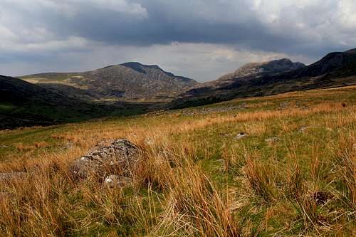
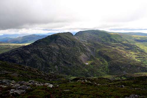
Rhinog Fawr (left) and Rhinog Fach (right) (Photo by Nanuls)
Children refers to the set of objects that logically fall under a given object. For example, the
Aconcagua mountain page is a child of the 'Aconcagua Group' and the 'Seven Summits.' The
Aconcagua mountain itself has many routes, photos, and trip reports as children.
Parents refers to a larger category under which an object falls. For example, theAconcagua mountain page has the 'Aconcagua Group' and the 'Seven Summits' asparents and is a parent itself to many routes, photos, and Trip Reports.