
|
|
Mountain/Rock |
|---|---|
|
|
52.90395°N / 3.92906°W |
|
|
Gwynedd |
|
|
Trad Climbing, Toprope, Bouldering |
|
|
Spring, Summer, Fall, Winter |
|
|
722 ft / 220 m |
|
|
Overview
The crags of the Rhinogydd are notoriously difficult to access, and as a result are known by few and are visited by fewer. However, there are a few exceptions, and as you might have guessed, Garreg yr Ogof (Rock of the Cave) is one such exception. The crag is sandwiched between Llyn Trawsfynydd, and the eponymous village of the same name, and takes the form of a single outcrop, some 15 metres in height, coupled with a series of shorter crags and boulders. Close to the road, and in beautiful surroundings, the crag offers a fantastic taste of what climbing in the Rhinogydd is all about. Furthermore, the crag’s handful of routes span the grading spectrum, making it an ideal venue for the experienced and inexperienced alike. The area surrounding the crag is significant from both an Environmental and a cultural perspective. Perhaps the area’s most obvious landscape feature is Llyn trawsfynydd, a 4.8 km² reservoir, originally created in 1928 as the header reservoir for the Maentwrog hydro-electric power station. In 1968 the Trawsfynydd nuclear power station was completed, and the lake was used to supply of cooling water to the power station’s twin reactor. Both reactors were shut down in 1991; and have since been in the process of being decommissioned by the Nuclear Decommissioning Authority. The power station is still clearly visible from the surrounding mountains. More significantly, one of Wales’ most famous poets, Ellis Humphrey Evans, known more commonly as Hedd Wyn, was born at Penlan, Trawsfynydd in 1887 the eldest of eleven children born to Evan and Mary Evans. The family moved to his father’s old home, "Yr Ysgwrn", a small hill farm about a mile to the east of the village, and it was here that Hedd Wyn lived most of his life. He began writing poetry at an early age winning his first chair at Bala in 1907 followed by chairs at Llanuwchllyn (1913), Pwllheli (1913), Llanuwchllyn (1915) and Pontardawe (1915). |
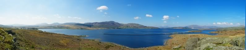
Llyn Trawsfynydd and the Rhinogydd (Photo by Nanuls)
In 1917 Hedd Wyn was called up by the army, and after a brief training period at a camp near Liverpool, he was sent to Flanders as a private in the 15th Battalion, Royal Welsh Fusiliers. During the same year, the National Eisteddfod of Wales was held in Birkenhead, and the subject for the chair was "Yr Arwr" (The Hero). Whilst in Belgium, Hedd Wyn decided to compete for the chair, completing the poem by mid July. On the 31st of July he was killed during the Battle of Passchendaele at Pilkem Ridge, aged 30. |
Rock Climbing
Most routes are located on the largest crag, while a number of shorter pitches have been recorded on the smaller crags to the south. A number of bouldering problems have also been recorded and published on www.ukclimbing.com, however I was unable to identify these satisfactorily, and so have decided not to publish them here. See the relevant www.ukclimbing.com page for further details. Routes are described from left to right, and are graded and with the aid of both the Climbers' Club Guide to Meirionnydd and www.ukclimbing.com. Technical grades are only given to climbs graded adjectivally as Hard Severe (HS) or above. Where the sources differ in their grading I have opted to list the highest quoted grade only, as I don’t want to mislead anyone about the seriousness of any of the routes. Please be aware that these routes have received relatively few ascents and so the grades are only rough approximations at best. I certainly felt that some of the climbs I did were quite high in their quoted grade. A conversion table for international climbing grades by SP member Corax is available HERE!. In addition, quality ratings have also been included, these are based on the three star system commonly used in British guidebooks. Be aware that this is a trad climbing venue and that bolting is strictly prohibited. |
|  Garreg yr Ogof Main Crag (Photo by Nanuls) | ||||||||||||||||||||||||||||||||||||||||||||||||||||||||||||||||


Routes on Garreg yr Ogof's main crag. For a clean version of the photo click HERE.
Below and to the right of the cliff, in the direction of a farmhouse, is a plethora of small rock faces, lots of bouldering, and four described routes. On top of the level area behind the farmhouse is a prominent block with a fine arête, which forms part of a low crag. |
 Garreg yr Ogof southern crags (Photo by Nanuls) |
| ||||||||||||||||||||||||||||||||
Further information and topos on bouldering at Garreg yr Ogof can be found over on UKClimbing. |
Mountain Conditions
This section displays the mountain conditions for Snowdonia, of which Garreg yr Ogof is part. Click on the widget for maps and further information. This Snowdonia weather forecast is generated by the Met Office Weather Widget |
When to Climb and Essential Gear
The most reliable conditions are in the summer, but the low altitude of the crag may make it a viable option in winter when the area’s higher routes are too wet to be enjoyable. The gear needed depends entirely on the routes you plan to do. Easier routes will only require a moderate rack, while harder routes will require a something more comprehensive; a good compliment of friends or other camming devices will certainly help. A singe 50 metre rope should serve well on most routes, however, twin or double ropes would be a wise choice for the harder stuff. |
Getting There
Turn off the A 470 at Trawsfynydd (SH 707 355) and park in the village. Walk down the lane along the left side of the large chapel in the village's centre, and follow it around to a small parking area and a church. Walk down the path that circles the church, cross a stone wall and the field beyond it to another stone wall. Cross this and walk across rough, unimproved grassland towards the lake and the crag (SH 704 356). |
Red Tape
No red tape of access issues here! For climbers, hill walkers and mountaineers, the British Mountaineering Council (BMC) runs a Regional Access Database, which holds mountain/crag specific information on matters of conservation and access, including issues such as nesting restrictions, nature designations and preferred parking: If you are in any doubt about any particular access arrangement, or need to report an incident, you should contact your local BMC Access Representative or the BMC Access Officers for Wales: Elfyn Jones. |


Camping and Accommodation
There’s an almost unlimited supply of accommodation within the Snowdonia National Park so it would be inappropriate to list it all here. For budget accommodation it’s worth checking out some of the following sites: Youth Hostel Association in WalesIndependent Hostel GuideCampsites in Gwynedd A good option for this crag is the Llys Ednowain Hostel in Trawsfynydd itself. You couldn’t get much closer! |
Maps
|
| Navigation Maps Ordnance Survey 1:25k Explorer Series OL 18 Harlech, Porthmadog & Bala/Y Bala Ordnance Survey 1:50k Landranger Series 124 Porthmadog & Dolgellau Harvey Map Services 1:25k Rhinogs/Rhinogydd Harvey Map Services/BMC 1:40k Snowdonia South Road Maps |
Guidebooks
|

External Links
 The main crag (Photo by Nanuls) The main crag (Photo by Nanuls) The smaller crags (Photo by Nanuls) The smaller crags (Photo by Nanuls)Government Bodies and Official Organisations Snowdonia National Park Authority Association of National Park Authorities Royal Commission on Ancient & Historical Monuments in Wales Hiking, Climbing and Mountaineering Organisations and Companies British Mountaineering Council Plas y Brenin National Mountain Centre Weather Tourist Information North Wales Tourism Partnership Local Information from Gwynedd.com Local Information from Snowdonia Wales Net Travel Welsh Public Transport Information Accommodation Youth Hostel Association in Wales Maps and Guidebooks Cordee Travel and Adventure Sports Bookshop Wildlife and Conservation |