|
|
Mountain/Rock |
|---|---|
|
|
52.81532°N / 3.98435°W |
|
|
Wales |
|
|
Hiking, Mountaineering |
|
|
Spring, Summer, Fall, Winter |
|
|
2480 ft / 756 m |
|
|
Overview
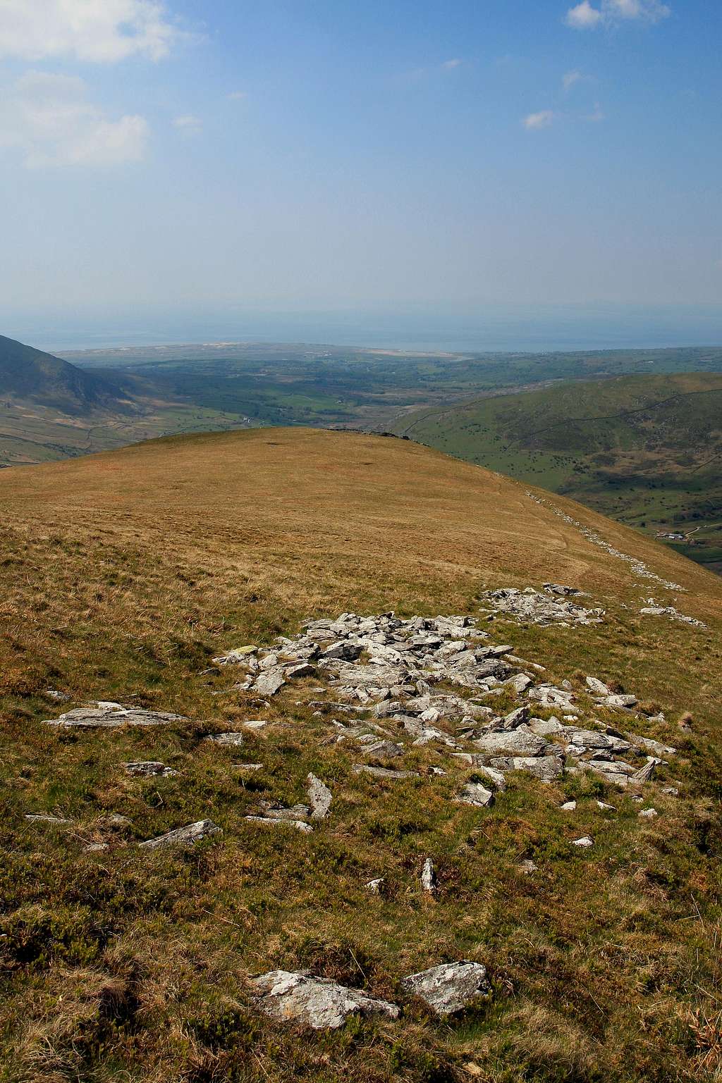
At a modest height of 754 metres above sea level, Y Llethr (which literally means ‘The Slope’) is the highest mountain in the Rhinogydd. Despite its preeminent height, it's one of the range’s least visited summits, the majority of visitors (though they be low in number) preferring to climb the arguably more interesting slopes of Rhinog Fawr and Rhinog Fach. There is little for the rock climber here either, since the majority of its known crags are too broken or too short to offer anything approaching a tangible line. So you may now be wondering, beyond a simple tick on an arbitrary list of summits, what does climbing Y Llethr have to offer? The answer, in all honesty, is not a whole lot. What it does offer is solitude, great views and a chance to visit a little bit of Wales that few others have seen, but considering what’s on offer elsewhere, this perhaps, is not quite enough. So if you’re intent of exploring the Rhinogydd and your time is limited, don’t succumb to the megalomaniacal pursuit of aiming for the highest point like so many seem to do, instead look to the range’s smaller summits, for they offer something far more satisfying. |
Mountain Conditions
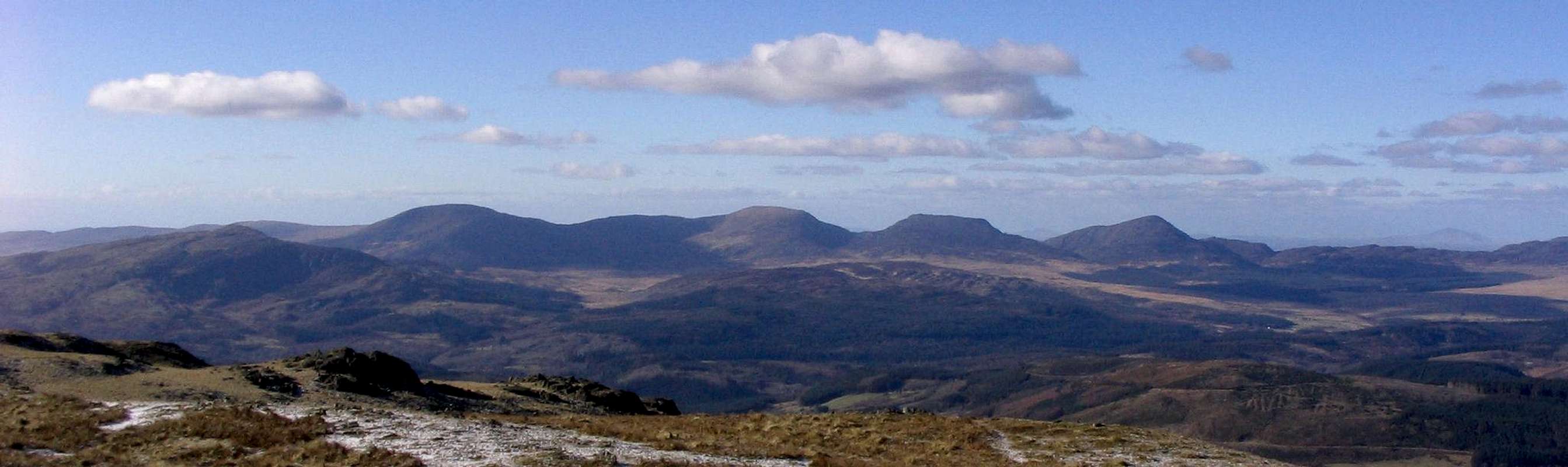
The Rhinogydd. From left to right - Y Garn, Diffwys, Y Llethr, Rhinog Fach and Rhinog Fawr (Photo by Nanuls)
This section displays the mountain conditions for the Snowdonia National Park, of which Y Llethr is a part. Click on the widget for maps and further details. This Snowdonia weather forecast is generated by the Met Office Weather Widget |
Essential Gear
Y Llethr can be climbed at anytime of the year, however in poor conditions the mountain's rock routes are best avoided, particularly if the weather has been wet. March to April offer the most reliable conditions. Of course this all depends on ones ability as a mountaineer/climber, and what might be comfortable for some may seem daunting to others. If you’re lucky enough to climb the mountain in winter conditions then an ice axe and crampons would be very useful. |
Getting There
Y Llethr is located in the southern portion of the Rhinogydd and can be approached from numerous directions. The best stars however, are all located on the range’s western side, either starting in Cwm Nantcol or Dyffryn Ardydwy. The best starting point is probably from near Cil-Cychwyn (SH 633 258) in Cwm Nantcol, which can easily be reached along narrow roads by leaving the A496, which runs along the coast from Llanulltyd near Dolgellau in the south to Blaenau Ffestiniog in the north, at Llanbedr or Dyffryn Ardydwy. Alternatively it’s also possible to approach the mountain from the south by parking at Bontddu (SH 672 188) or Cwm Mynach (SH 684 215). The routes from here are less satisfying that the other options though. The area can also be reached by rail, however getting from the stations to the mountains themselves can be difficult as public transport is pretty infrequent and hitching can be a bit of a nightmare these days. |


Red Tape and Access
No red tape or access issues here! For climbers, hill walkers and mountaineers, the British Mountaineering Council (BMC) runs a Regional Access Database, which holds mountain/crag specific information on matters of conservation and access, including issues such as nesting restrictions, nature designations and preferred parking. If you are in any doubt about any particular access arrangement, or need to report an incident, you should contact your local BMC Access Representative or the BMC Access Officers for Wales: Elfyn Jones. |
Camping and Accommodation
There’s an almost unlimited supply of accommodation within the Snowdonia National Park so it would be inappropriate to list it all here. For budget accommodation it’s worth checking out some of the following sites: Youth Hostel Association in Wales For more local options, there are a number of campsites that surround the range. Nearby campsites can be found at Cae Gwyn Farm (SH 713 297) to the east of the range, and Merthyr Farm (SH 600 319) to the west. For wild camping Llyn Hywl (SH 662 267) and Llyn Bodlyn (SH 648 239) make an excellent locations.  Y Llethr (Photo by Nanuls) |
Maps
|
| Navigation Maps Ordnance Survey 1:25k Explorer Series OL 18 Harlech, Porthmadog & Bala/Y Bala Ordnance Survey 1:50k Landranger Series 124 Porthmadog & Dolgellau Harvey Map Services 1:25k Rhinogs/Rhinogydd Harvey Map Services/BMC 1:40k Snowdonia South Road Maps |
Guidebooks
|
|


External Links
 Y Llethr (Photo by Nanuls) Y Llethr (Photo by Nanuls) Rhinog Fach (Photo by Nanuls) Rhinog Fach (Photo by Nanuls)Government Bodies and Official Organisations Snowdonia National Park Authority Association of National Park Authorities Royal Commission on Ancient & Historical Monuments in Wales Hiking, Climbing and Mountaineering Organisations and Companies British Mountaineering Council Plas y Brenin National Mountain Centre Weather Tourist Information North Wales Tourism Partnership Local Information from Gwynedd.com Local Information from Snowdonia Wales Net Travel Welsh Public Transport Information Accommodation Youth Hostel Association in Wales Maps and Guidebooks Cordee Travel and Adventure Sports Bookshop Wildlife and Conservation |