
-
 9524 Hits
-
 83.69% Score
-
 17 Votes
|
|
Mountain/Rock |
|---|---|
|
|
42.61844°N / 0.67061°E |
|
|
Download GPX » View Route on Map |
|
|
Mountaineering, Scrambling |
|
|
Spring, Summer, Fall |
|
|
10522 ft / 3207 m |
|
|
Overview
 Russell
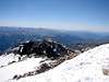
The peaks of Russell are a group of summits at western part of Maladeta massif. The main summit is surrounded of another five secondary summits over 3000m and all are an objective to collectors of three-thousands but for a lot of mountaineers the main summit is the best target, an impressive peak surrounded of rocky ridges.
Normal route is from Vallibierna-Puente de Coronas. It’s the trailhead for another most popular peaks as Aneto ( 3404m), the highest of Pyrenees, Araguëlls ( 3037m), one of the easier peaks of 3000m of Pyrenees, or Vallibierna (3067m), impressive and nice peak. For this reason it’s not a very popular summit in the area, the routes are long, the climb is not a walk-up, the access is not easy to find,… but is probably one of the greatest peaks in the area and one of the best climb for the mountaineers.


Picos de Russell / Peaks of Russell
 Russell
-Russell or Russell NW ( 3207m), F, the main summit. The normal route is across Diagonal SW. Other routes: Channel South (F.sup.), Ridge SE (P.D.sup.)
-Punta de la Brecha Rusell (3192m), F, at NW of main summit, it’s over the Brecha Russell, the gap with the ridge of peak Margalida (3192m). With an easy access from the exit of Diagonal NW, the normal route to main summit.
-Aguja Russell SW (3029m), P.D. (II+)., at SW of main summit, the only one without access from the main summit, with its own route.
-Punta Oriental de Russell (3034m), F, far summit at the SE, descent from the normal route of main summit of access across the channel S.
-Antecima SE de Russell (3205m), F, very little summit, the image of the summit from the west, but really a pre-summit (antecima).
-Aguja Sur de Russell or Aguja Superior de Russell (3146m), P.D.inf. (II), it’s possible to reach the summit descending from the main summit across the Antecima SE and descending the ridge South-East. The climb of ridge SE from the bottom is P.D.sup. (III).


Henry Russell
 H.Russell
 Pico Russell
Henry Russell ( Toulousse 1834, Biarritz 1909), was one of the fathers of Pyreneism. His father was Irish and his mother French and he was Count. He was the first man to climb many of the important summits of the range. All his life he explored the Pyrenees, and other parts of the world, and he discovered many of the normal routes and the way what he followed to conquer the summits are useful today. In 1865 with his English friend Charles Packe (1826, 1896), he climbed this peak for the first time across the route S.E., not the normal today. He written the book “Souvenirs d’un montagnard” in 1904 with all his climbs of Pyrenees and it’s still today a very popular and interesting book. The mountaineers of the epoch give the name to these peaks in his honor.
I copy the words of Russell about the first climb of the peak "I climbed a leading pyramidal peak, to which I called Small Aneto, but to which had done itself me the honor to call later, the peak of Russell. It was alone and him did not I climbed more than by mistake, having taken for another. Without being dangerous it is very far from being easy. It forms the extremity of a very high and quite rough ridge that the Aneto radiates to the Southeast, and that does not descend under 3200m.". His friend Packe waited in the campgroud fishing but the shepherds stole them the trout that he was fish and they slept badly with cold, hungry and thinking if the thieves could return.
More information in the great article of Visentin: Russell
Getting There
 Russell and Aneto
Approach to Benasque from Huesca: in the road on direction to Barbastro (N-240). After Barbastro we'll follow the indication to valley of Benasque to the C-1311 to Graus and the C-139 to Benasque across the beautiful gorge of Congosto de Ventanillo.
-Puente de Coronas: across the track of Vallibierna in the south of Maladeta Massif. The entry is signaled in the road from Benasque to Hospital de Benasque. After the cross of Cerler we'll arrive to the signal "Vallibierna/Senarta", where's the entry to camping of Senarta. At end of plain in right side is the forest track of Vallibierna (11 km).
Red Tape
-Summer (july-august-september): the track of Vallibierna is closed and we'll must to pay the bus.-Spring (may-june)-Autumm (october-november): is possible the approach in car but the track it's not always in good conditions early in the season after the winter. In october-november it's possible the first snowfall and is very dangerous to drive in the track.
-Winter: track closed for risk of avalanches.
The best option is always to search information about the access to Vallibierna in tourism office of village of Benasque.
Camping
Camping is not allowed in the area generally but you had two good options:-Camping of Senarta (at the beginning of the track of Vallibierna): very economic, with w.c. and green zone to put the tent.
-Refugio de Coronas (at the end of the track): free hut with space for a few of persons in beds and the floor.
It exist a lot of hotels in the village of Benasque.
External Links
Picasa-album : album of images of our climb in august of 2007.Henry Russell: information about Russell in French.
Wikipedia: Henry Russell , information about this great explorer of Pyrenees in english.