

-
 34356 Hits
-
 88.19% Score
-
 26 Votes
|
|
Mountain/Rock |
|---|---|
|
|
48.72510°N / 113.71°W |
|
|
Mountaineering, Scrambling |
|
|
9127 ft / 2782 m |
|
|
 Bishops Cap from Logan Pass (south).
Going-to-the-Sun Highway is in the foreground.
The Highland Trail can be seen rising diagonally above it from the lower right.
Bishops Cap from Logan Pass (south).
Going-to-the-Sun Highway is in the foreground.
The Highland Trail can be seen rising diagonally above it from the lower right.
 Setting - above Logan Pass
Bishops Cap second from left.
Setting - above Logan Pass
Bishops Cap second from left.
 From the west.
Bishops Cap far left.
From the west.
Bishops Cap far left.Overview
 From the south
on the Garden Wall.
From the south
on the Garden Wall.Bishops Cap is located north of Logan Pass along the Garden Wall between Mount Gould and Pollock Mountain in Glacier National Park. The peak gets its name from the fact that when viewed from Logan Pass it has the appearance of a Bishop's Cap. The name is spelled without an apostrophe. Even though it is well known in the Park and a named summit over 9,000 feet on the USGS topographic map, Bishops Cap is not included in A CLIMBER'S GUIDE TO GLACIER NATIONAL PARK, or in CLIMBERS GUIDE TO MONTANA. In fact, neither of these guidebooks even mentions the peak.. There is only one established route on Bishops Cap (West Ridge) and the climbing history of the peak seems to be unknown. I have not been able to find any references to a first ascent.
Views from Bishops Cap
 North to Mount Gould.
 |  SW to Logan Pass and beyond.
 |  S on a strange weather day.
 |
Getting There
 From the east.
Glacier National Park is located in northwestern Montana. Going-to-the-Sun Road is the main scenic route through the Park and the way to Logan Pass and Reynolds Mountain. It is not kept open during the winter. Closing in the fall and opening in the spring depends on snow depth and conditions. Opening can be as late as July. Current Road Status A map of the Logan Pass area: Logan Pass Area Map The climbing route on Bishops Cap can be approached either via the Highline Trail from Logan Pass or from the summit of Pollock Mountain via its north ridge and a traverse along the top of the Garden Wall.
Climbing on Bishops Cap
 High above GTS Road.
On the West Ridge.
High above GTS Road.
On the West Ridge.SPECIAL CONSIDERATIONS: Because of the nature of the rock, there are special considerations regarding climbing in Glacier National Park, and grading systems unique to the Park have been developed. Please see this Fact Sheet for further details: GNP Rock & Grading Systems See the attached West Ridge Route Page for details and more photos of this climb.
Red Tape
Current Entrance Fees Registration for day climbs in Glacier National Park is recommended, but not mandatory. Outdoor Activity Page Includes links to boating, bicycling, fishing, etc. and the regulations applying to each.
When To Climb
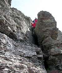 Chimney on West Ridge.
June, July, August, September, and even into October depending on the amount of snow and the road closures.
Camping
There is no camping at Logan Pass. There are numerous campgrounds available within Glacier National Park: Backcountry Camping Page Includes trail status reports, campground availability, daily backcountry bulletins, and a backcountry blog. Car Camping Page There are also many campgrounds just outside the Park on both the west and east sides. Camping on the Blackfeet Reservation is restricted to established campgrounds only.
Mountain Conditions
Weather Page an overview with a link to the local forecast. Webcam Page
External Links
Logan Pass Photo Gallery National Park Service page showing pictures from the Logan Pass area Glacier National Park Homepage Glacier Mountaineering Society Non-government Glacier National Park Information