|
|
Mountain/Rock |
|---|---|
|
|
46.38243°N / 7.87681°E |
|
|
Hiking, Mountaineering, Trad Climbing, Mixed, Scrambling |
|
|
Summer, Fall |
|
|
10537 ft / 3212 m |
|
|
Overview
Stockhorn - best approach via Baltschiedertal, 5 - 6 hrs to base of climbs based on where you want to start.Getting There
Rhone Valley - drive to Visp, then up to Ausserberg (main station). From here either hike in the Baltschiedertal or do the additional car ride to P. 1264 (Stollen) and walk along the Niwärch (a historic irrigation channel) into the valley. If you want to drive up to the parking lot you will need a permit (available at the hotel near the main station).The path is flat and sometimes exposed as you walk along the Niwärch channel. When reaching Üssers Sentum, the path starts to ascend. At Senntum (some scattered huts), cross the bridge over the Baltschiederbach. Now the path is flat again for a while. At Chiemattu it starts to zig zag uphill until a traverse to the left and across the Baltschiederbach brings you to Martischipfa (1940 m). From there it continues to climb until you reach the very tiny chapel at Hohbitzu (2199 m). Leave the path and walk uphill, bearing north-west(some cairns) until you reach the beginning of a big colouir (mark on the rock wall) which allows to surmount the rocky barrier below the Stockhorn-Biwak. After about 100m up the rocky couloir trend right, follow the chains traversing the wall. This part is quite exposed and strenuous. The chains guide you to a grassy flank - here you follow a climbers path until you reach a boulder field. The Stockhorn-Biwak lies across this field, on top of a low rocky wall.
Red Tape
The whole region is protected by UNESCO.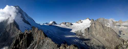
Further information see at External Links section below.
Camping
There's two bivouac sites (Martischipfa & Stockhorn-Biwak). Martischipfa (1940m): 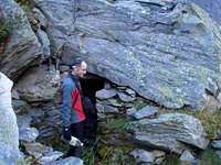 ~ 60m away from the bridge. The bivouac is situated under a big boulder. It sleeps 3 to 4, is very rudimentary but has a reliable water source. From here one has also access to the SW facing routes on Stockhorn. |
Stockhorn-Biwak (2598m): 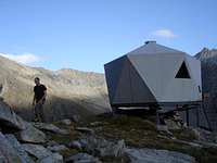 Access to this bivouac involves a small via ferrata which can be slippery and wet (east-north-east facing) - chains! Equipped bivouac, no warden. Carry up a stove and fuel. Blankets are there. Sleeps up to 18 persons. No reliable water source, especially end of season. Sometimes, water can be found at the boulder field below the hut. The water source is close to the path. Easy & quick access to south ridge and standard east ridge route, access to SW-facing routes takes longer and involves abseiling except for one route. |
You can also stay in the Baltschiederklause: hut with warden, open in the summer months, detailed information see below. |
Maps
- Landeskarte der Schweiz 1288, Raron, Scale 1:25,000 (first part of walk-in)
- Landeskarte der Schweiz 1268, Lötschental, Scale 1:25,000 (second part of walk-in, Martischipfa, Stockhorn-Biwak, Stockhorn)
External Links
- Stockhorn bivouac (with map click here)
- Baltschiederklause
- The protected region UNESCO WORLD HERITAGE Jungfrau-Aletsch-Bietschhorn