
-
 8761 Hits
-
 84.82% Score
-
 19 Votes
|
|
Mountain/Rock |
|---|---|
|
|
48.36503°N / 113.34841°W |
|
|
Flathead and Glacier |
|
|
Mountaineering |
|
|
Spring, Summer, Fall |
|
|
7820 ft / 2384 m |
|
|
Layout designed for best viewing on a "1024 x 768" screen.
 |
|---|
The Mummy presents an enjoyable interlude for
those who are willing to unravel its secrets.
 Cliffs below the head of The Mummy with Calf Robe Mountain in the distance
In Glacier National Park lies an innocuous section of jumbled ridge between Summit Mountain and Calf Robe Mountain. Although it is not officially named by the park service or the USGS, some locals refer to this section of the Continental Divide as “The Mummy”.
But first to set the mood here are a few puns regarding Mummies.
Q. Why did the mummy call the doctor?
A. Because he was coffin.
Q. Where do mummies go for a swim?
A. To the Dead Sea.
Q. What kind of music do mummies listen to?
A. Wrap
Q. "What did the mummy say when he got angry with the skeleton?
A. I have a bone to pick with you,'
Q: Why does the Mummy keep his Band-aids in the refrigerator?
A: He wants to use them later for cold cuts!
An Introduction to The Mummy
 A view from The Mummy, an echoguy photo
 View from The Mummy
In the 1999 Oscar nominated film,”The Mummy” with Brendan Fraser and Rachel Weisz, the mummy, High Priest Imhotep, is awakened. Doom, gloom, and death were sure to follow and it took practically everything the stars had to send the mummy back where he belongs.
Glacier National Park has its own unofficial mummy. Depending upon the vantage point the ridge line between Calf Robe Mountain and Summit Mountain looks much like a mummy. The complete torso can be seen lying along the ridge from the northeast to the southwest. The head and neck are closest to Calf Robe Mountain and the toe is formed by a unique pillar that is on the northeastern flank of Summit Mountain. From head to toe the body of The Mummy is made up of approximately 1.5 miles of the Continental Divide.
The Mummy in Glacier National Park has not moved for thousands of years and will not awaken any time soon so you are safe to explore.
This is not a difficult area to explore.
Ridge walks are certainly a highlight of climbing in the Marias Pass area.
Climbing parties can walk for miles and miles without even following a hiking trail after reaching the Continental Divide.
It is possible to walk all the way from the summit of Elk Mountain to Scenic Point or even Never Laughs Mountain without following a hiking trail. The Firebrand Pass Trail would be crossed enroute.
This distance is probably over 20 miles.
It is more than likely feasible to continue to Grizzly Mountain as well but I have not heard of anyone doing that traverse from near Bearhead Mountian to Grizzly Mountain.
Getting There:
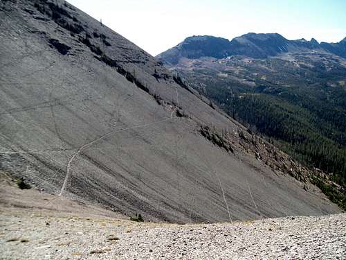
 The Mummy from the Lubec Lake Trailhead
To visit Glacier National Park is to enter a place where Heaven touches Earth affording brief glimpses into the Wonders of Creation.
Glacier National Park’s The Mummy is located in northwest Montana.
U.S. Highway 2 between West and East Glacier weaves between the mountain in the Flathead Range to the west and the incredible peaks of the Clark Range in Glacier National Park to the East. The highway follows the Middle Fork of the Flathead River as it forms the boundary of the southwestern side of Glacier National Park and actually passes through a small portion of the park to the East of Essex, Montana. Just east of the park U.S. Highway 2 follows Bear Creek to Marias Pass. Marias Pass was influential for the Transcontinental Railroad and was “discovered” by John Stephens as he searched for a route through the mountains.
The Firebrand Pass Trail takes off from the Lubec Lake Trailhead. The trailhead is located at mile marker # 203 on U.S. Highway 2 on the west side of East Glacier, Montana.
Montana is a long way from most places. That’s why many of us live here. It is possible to get here, but you have to really want to get here.
You can get here how ever desired as air, bus, train and even highways serve the Flathead Valley!
Red Tape:
For all of the rules and regulations for Glacier National Park please visit the park website.Vehicle single entry fee for Glacier National Park is $25.00 for 7 Days, $12.00 per person for single hiker, motor biker or bicyclist. An "America The Beautiful Federal Lands Recreational Pass" for goes for $80.00 which gives entrance to all National Parks, National Forests, BLM, US Fish & Wildlife, and Bureau of Reclamation sites for one year from date of purchase. See Plan Your Visit for other information regarding all of the National Park entrance fee information.
If you are planning on visiting Waterton Park make sure you have a passport to simplify crossing the border.
You do not have to register for day climbs in Glacier National Park but it is recommended. Backcountry travel regulations can be found at Backcountry Travel. There is also information from the Park Service on Mountain Climbing in Glacier.
Route Information:
 Following elk trails to the saddle
 Above the trees in the open
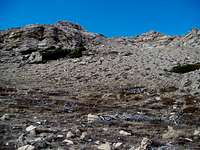 Approaching the saddle
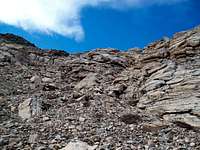 Cliffs below the saddle
The easiest access to The Mummy is located above the Autumn Creek Trail from either the Lubec Lake Trailhead or The Autumn Creek Trailhead (Marias Pass Access). The Mummy could also be accessed from Firebrand Pass as well as the Ole Creek Drainage.
The recommended route begins at the Lubec Lake Trailhead. The Coonsa Trail (also referred to as the Firebrand Pass Trail on some maps) leaves U.S. Highway 2 at the Lubec Lake Trailhead which is located at mile marker #203. There is ample parking near the trailhead. Walk across the railroad tracks after checking for fast moving freight trains and the Amtrak passenger trains.
The Junction with the Autumn Creek Trail is 1.4 miles (2.3 km) from the Lubec Lake Trailhead on U.S. Highway 2.
Follow the trail to the west (left) at the junction and forge through the woods after crossing the second stream drainage. There may not be water in the drainages but the crossings are obvious. Head off through the woods towards the open slopes below Calf Robe Mountain. There are numerous game trails criss-crossing this area so follow them if they seem convenient.
Whenever possible look up the slope and locate the head of The Mummy and continue climbing to the saddle between the head and Calf Robe Mountain. Eventually the scree fields below the Continental Divide will be reached and they require a short scramble through the scree and up some broken cliffs to the ridge. There is about 2,000 feet of elevation to gain between the trailhead and a saddle near Point 7098.
Once at this low point along the ridge the remainder of the climb is a scramble along the ridge line towards Summit Mountain.
 Climbing from the saddle to the head
 Looking from the head to the torso
The Head:
A goat trail extends along the Ole Creek side of the ridge from the saddle. To reach the high point of this feature scramble up the slope from the goat trail. The summit of the head actually hangs off a massive cliff that drops straight down at least 500 feet.
A small crack along the summit ridge was also located indicating that the forces of thawing and freezing continue to have their effects on the geology of Glacier National Park. Eventually part of this ridge will collapse and end up on the great scree fields below the summit ridge.
 Traversing below the torso
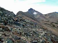 Traversing below the torso
The Torso:
Follow the goat trail below the ridge from The Head towards the neck of The Mummy. There is a Class 3 or 4 portion of rock before reaching the pass (the neck) between The Head and The Torso. This can be avoided by following a lower goat trail underneath the cliffs.
After crossing over the pass the goat trail follows the ridge for about 100 feet of elevation gain and then once again traverses on the Ole Creek side of the ridge. To reach the high points along the ridge do not follow the goat trail. Continue up the ridge line and hit all of the high points.
If your goal is to reach the Big Toe it is quicker to follow the mid-slope goat trails to the west towards Summit Mountain.
 Vantana looking at the Big Toe and Summit Mountain
The Big Toe:
The following information was provided by EarMountain. He writes "GMS founder Dennis Twohig climbed this spire many years ago and dubbed it the "Big Toe." GMS publications refer to it that way."
EarMountain also wrote that there are "High class 4 above the Lewis Overthrust fault and near the summit." Click Photo on The Big Toe to see EarMountain's photo of summitting of The Big Toe.
We did not climb the Big Toe.
The day we summitted The Mummy (October 20, 2010) it was quite windy and we had time commitments which limited our opportunity to explore further down the ridge. The Big Toe requires climbing gear on Class 4 to 5 rock.
From the Big Toe it is also possible to make an extended trip to climb Summit Mountain via the Continental Divide on the Northeast Ridge or drop down into the Ole Creek drainage and climb Skeleton Mountain, a small rounded peak with an interesting name.
It is also possible to exit off of the Continental Divide back down to the Autumn Creek Trail to return to The Lubec Lake Trailhead.

|

|
|---|
 Firebrand Pass goat trails leading to The Mummy
It is possible to follow goat trails from Firebrand Pass to the below the Ole Creek side of the ridge. From there it looks like there are ample areas to climb to the ridge top and traverse The Mummy. This writer has not completed this route but J. Gordon Edwards writes that there is a goat trail that travels from Firebrand Pass to Summit Mountain.
The goat trail traverses along the Ole creek side of Calf Robe Mountain from the saddle near Point 7098 to Firebrand Pass. This writer has not completed that traverse but the goat trail is obvious.
Optional Side Trips:
At 8,770 feet in elevation, Summit Mountain can be reached from The Mummy via a goat trail below the crest of the Continental Divide. Edwards describes this option in his Routes Among The Peaks Section on page 315. This looks difficult but would be doable in a long day and would require some significant gains and losses in elevation.
 The Mummy Topo Map and Route
A long day trip, with a two-day trip being much more enjoyable, down the Ole Creek Drainage to Walton Ranger Station could prove entertaining. Make sure you have a campsite reserved at Ole Lake before leaving for this overnight trip. From that trail Eagle Ribs Mountain, Mount Despair, the Barrier Buttes, Brave Dog Mountain, Sheep Mountain and Salvage Mountain may be able to be reached with some creativity and perhaps some serious bushwhacking. Be prepared to deal with bears, as this is a remote seldom-visited corner of the park. There may be easier routes to reach these peaks.
Special Considerations: The rock in Glacier Park is widely varied and it is not unusual to find several different types of rock on any given route. Know your rocks and be certain of your safety. J. Gordon Edwards has an excellent section in his guidebook on rock and climbing safety. Be safe and know your limitations as well as those who are climbing with you. Also refer to the following links for further details: GNP Rock and Grading System and the GMS Climbing Guidelines.
When to Climb
 The Mummy from Calf Robe Mountain
Timing of this climb may not be as crucial as deciding whether there is a desire to deal with the grizzly and black bears that frequent this area. Stay alert and use caution and good bear etiquette while climbing The Mummy. My father-in-law rode horses into the Ole Creek Drainage in the 1970s and at that time the gentleman he was with told him that maybe 10 people made it to the Ole Creek drainage every year. I am confident that the number of visitors is higher now but this area is remote compared to the peaks along Going-to-the-Sun Highway.
When to climb The Mummy presents an interesting conundrum. Climb early spring or even late fall and deal with snow or climb late and deal with a hot, dry route.
Perhaps the most logical time to climb is late August or early September when the temperatures cool and Montana usually is enjoying what is referred to as “Indian Summer” (my apologizes to any Native Americans). If you wait too long the risk of skiffs of snow increases as does poor weather. It is all an issue of timing.
Camping Information and Equipment:
The nearest campground is a USFS Campground at Marias Pass. Spots are available on a first come basis.This is bear country! Bring bear spray and know how to use it.
Crucial gear includes: bear deterrent spray, extra water, sturdy footwear and a camera
Weather:
External Links:
Glacier National Park in PicturesGlacier Mountaineering Society
Visit Montana
Fred Spicker - Jun 27, 2014 1:30 pm - Voted 10/10
Big Toe approachThe area along the Autumn Creek Trail where you exit to approach the base of The Big Toe is about equidistant from both the Lubec Lake Trailhead or the Autumn Creek Trailhead at Marias Pass – about 4.5 miles from either. There is a much shorter and very easy alternative. Between mile posts 199 and 200 on the highway is a culvert under the railroad tracks which carries a large stream. According to the 2006 GMS Journal article this is about .2 miles west of milepost 200 and .8 miles east of milepost 199 (my odometer does not do tenths). It is quite easy to spot and you can park right at the culvert. From here, it is only about 1.25 miles to the Autumn Creek Trail and the area where you continue upward to The Big Toe. Total distance from the road to the base of the climb is about 2.5 miles. On both the topo map and satellite image you will note a very continuous open area extending from the tracks nearly to the trail. This is a long open meadow above the creek that goes through the culvert. If you start up less than 100 feet east of the culvert and follow openings upward and roughly parallel to the creek, you should find yourself in this open country and enjoy a relatively easy cross country trip. The culvert / starting point is at about 48.3388934 / -113.326131