
-
 7101 Hits
-
 74.92% Score
-
 5 Votes
|
|
Custom Object |
|---|---|
|
|
46.31847°N / 13.77941°E |
|
|
valley |
Overview
In the Valley of Triglav Lakes
Intro
Until now, a chapter about the Valley of Triglav Lakes was embedded in the Bohinj Group page. As this valley is one of the landmarks of not only Julian Alps, and as such a very worthwile goal of a mountain trip itself, I decided to dedicate it a special page. So, it can be more easily found and referred to.
In addition to the above name (in Slovenian it is: Dolina Triglavskih jezer), the valley has also the following names: Dolina Sedmerih jezer (The Valley of Seven Lakes), more rarely Jezerska dolina (The Lakes valley) and Dolina Zajezerom or Za jezerom (The Valley Behind the Lake).
General
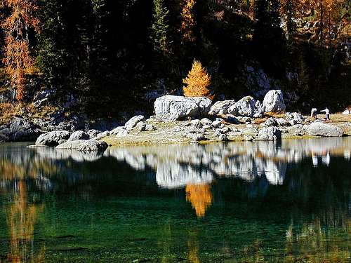
The Valley of Triglav Lakes is a karstic, high mountain valley in the heart of Julian Alps. It is characterised by many small lakes and a beautiful mountain landscape. No wonder that it lies in the core part of Triglav National Parc. Actually, the parc history started there. Already in 1924 the valley was protected as an alpine protected parc. The name of Triglav National Parc was used first in 1926 and later the area of protection was much broadened.
The valley is primarilly a goal of hikers. It is reachable by marked paths from many sides, but none of the approaches is shorter than 3 hours. As said, even visiting only the valley is worth of a trip, but as a one day tour we can do also an ascent on the summit of Velika Tičarica or even Veliko Špičje. Climbers will not find much in the valley. In the past some climbs were done in the walls of neighbouring mountains, but today they are not very popular any more. In winter and spring the valley is visited on skis. Until the wall of Komarča is not free of snow, the most recommended tour is from Komna, but that requires sleeping in one of the huts in the area. The best ski tour goal above the valley is Kanjavec, nice are also long ski hikes on the mountains shared by the Komna plateau.
Protected Nature
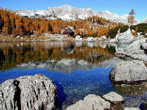
Dvojno jezero
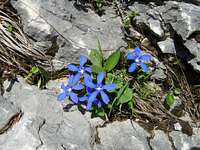 peterbud - Spring gentian
 peterbud - Alpine snowbell
On the Triglav National Parc page you can find general rules about behaviour in the area, but if you are aware of not taking anything from there and not leaving anything there, the common sense is sufficient. The ecosystem in the parc is very fragile, so camping is forbidden, swimming in the lakes as well. Be aware that noise is also polution!
Interesting is the story about a "smart" guy who decades ago brought a bucket full of fish and released them into Dvojno jezero (Double lake, the one by the hut). Well, Triglav lakes are small and they don't have any stronger surface inflow or outflow of water. The fragile ecosystem was soon destroyed by those fish. Hungry as they soon were, they ate all of small plankton shrimps who in turns were for centuries eating green algae in the lake. So today additional measures have to be taken to fight against algae and they are never successful.
The lakes are of course not the only attraction of the valley. Along the marked paths, but even more if you hike off the beaten paths, you will be able to admire several beautiful karst phaenomena: slanted limestone slabs, all eroded by water, chiasms, holes, unusual rock formations etc. Going off the beaten paths is often hard, it can be also dangerous. The terrain is rugged, overgrown with dense dwarf pines, don't dare to go across a pathless terrain in fog or poor visibility! Also flora and fauna in the valley are very nice.
 |
It is no wonder that people had placed the story of Zlatorog (Goldhorn) into these places. Is the Valley of Triglav Lakes the lost paradise, destroyed by the rage of Goldhorn? Are these the remains of beautiful gardens? Were the grooves in rocks perhaps not made by water but by horns of a raging animal? Click on the picture left to read The Tale of Goldhorn! |
The Origin
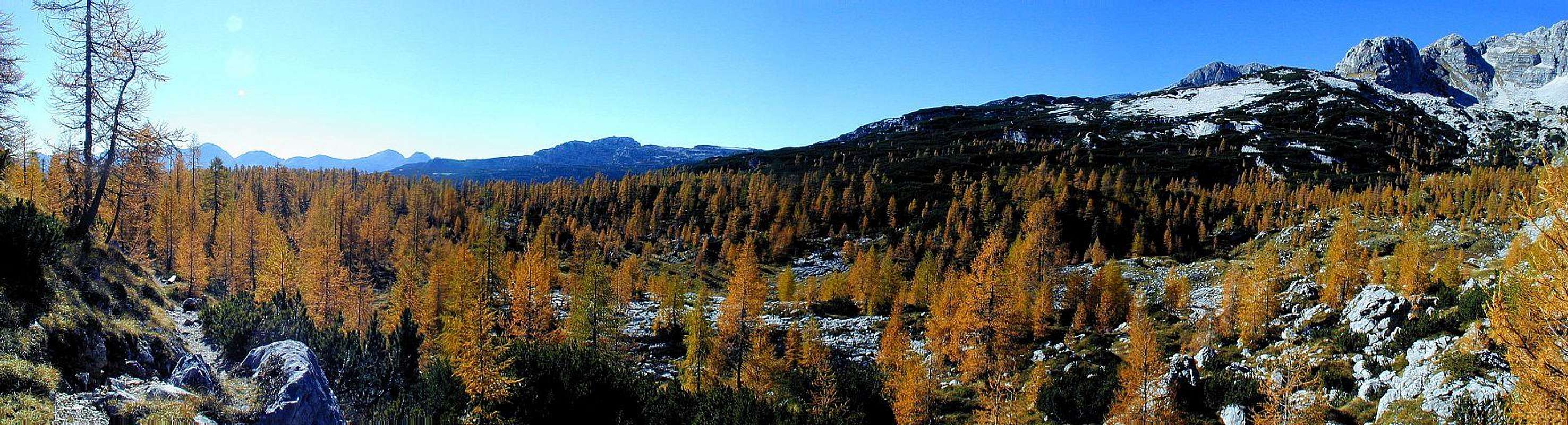 Autumn in the Valley of Triglav Lakes
The majority of Julian Alps is built from triassic limestone, through which almost all water poures underground. But Triglav Lakes lie on a jurassic limestone layer, which holds water better. In addition, glaciation helped with debris and glacial lakes sediments, which blocked eventual cracks in the bedrock. The reddish jurassic limestones can be seen on many places in the valley. In the rocks you will often find also petrified animals from millions of years ago. An interesting example are ammonites. The neighbouring mountains are made of older triassic limestone. The mountain chain from Tičarica to Zelnarica, which borders the valley on the east, is actually the western edge of a huge thrust (of Cordevole/Triglav limestons), which was pushed from the north-east over the younger triassic dachstein limestones (the whole western side of the valley) and over jurassic rocks (middle of the valley). The shape of the valley is also result of two thrust lines, going in a wedge-like shape. One goes in the north-south direction along the very eastern side of the valley, the other one goes in the northeast-southwest direction along the western lying mountain chain of Veliko Špičje. Between these two thrust lines the valley is gradually sinking - in a form of several valley steps, which have so also a tectonic origin.
The second source of factors which shaped the valley are the outside impacts of glaciation and meteoric water. In the last big glacial age (Wurm period) these mountains were completely covered with glaciers, only the highest peaks were free of them. In the upper part a smaller glacier was coming down from the area between Vršac and Kanjavec, the other bigger one was coming down from the Hribarice plateau and Kanjavec. Moraiines of these glaciers are not big, but clearly seen. Other glaciers were coming down from the long range of Veliko Špičje, but they were south oriented. The flow of all these glaciers had a significant impact on the dachstein limestones (forming big plates and slabs), but the jurassic limestones were not erased so easily, so different kinds of remaining rock structures are exhibited there. Finally, after the retreat of glaciers, meteoric water started its persistent work. The effects are seen everywhere, that's why the Valley of Triglav Lakes is one of the most beautiful examples of high mountain karst.
Geography
The valley stretches in a mostly south-north direction from the altitude of around 1300 m above Komarča (near Črno jezero) to the altitude of around 2000 m in the upper end. Actually, it is not in a form of a straight line, but more as a long arc. Morphologically we can speak about three parts of the valley.
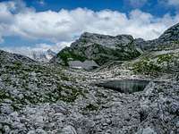
The upper part is the real Valley of Triglav Lakes. On the south it finishes with a 100 m high valley step near Bela skala (White rock), a distinct rock formation which we pass en route.
South-west of the upper valley, from the N-NW direction another, lower valley comes down. It is called Lopučnica and is mostly covered with a dense forrest (a cleaning is only in the upper part - ex pasture). This valley then ends on the SE, above the abysses of Komarča. So, the lowest of the lakes, Črno jezero, actually lies in Lopučnica valley (so its water background and flow is different than the one of all other lakes).
The third big part of a broader Valley of Triglav Lakes is a broad, high, a bit slanted plateau of Zgornja Komna. The real Komna plateau lies much towards the south. It has many areas and Zgornja Komna can also be treated as one of them. It has all the same characteristics, but being embedded between the two main mountain crests which border the valley of Triglav Lakes, we can treat that area as well as a part of our valley.
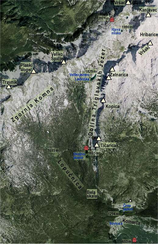
There have been long discussions how many lakes are there in the valley. Well, occasionally some more, because only the biggest ones are permanent. Seven is only a generally popular number with folks. Let's name the most important ones.
The Lakes Described

|
|
|

|
|
|

|
Getting There
The Valley of Triglav Lakes can be reached from many sides. All the approach routes have been already described on SummitPost:
- From Koča pri Savici over Komarča. 3 h, partially exposed and protected, well beaten path. Difficulty: T3.
- From Koča pri Savici over Komna. 5 h, easy, appropriate also as a ski tour. In summer conditions difficulty T2.
- From Blato alpine meadow. 3 h 30 min, only one passage (Štapce) exposed and protected, detouring it south is some 10 min longer. T2/T3.
- From Trenta through Zadnjica valley. 3 h 30 min, medium hard hike, T3.
- From Trenta over Trebiščina meadow. 4 h 30 min, medium hard hike, T3.
This year (2019) the route over Komarča was formally closed after a deadly accident of an experienced Dutch hiker. It was said that protection devices were ruined, even worse, some remains of pegs and hooks were hidden below leaves, so you could be hooked by those "traps" and fall. It is announcer that the trail will be repaired until August 25th.
Hikes
If you stay longer in any of the two mountain huts, you can do some nice ascents on the neighbouring mountains. They are described on their respective pages.
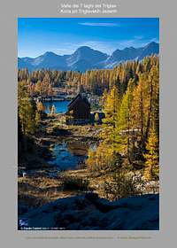
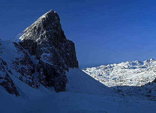
The summit of Tičarica rises just above the hut
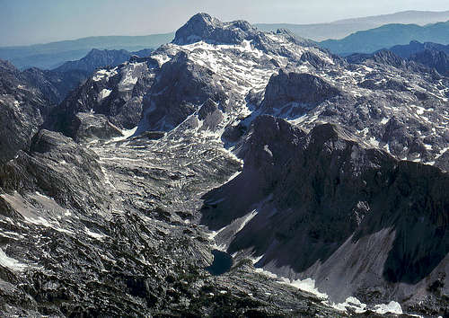
The upper part of the valley from a plane
Mala Tičarica, 2071 m. 1 h 15 min from the hut, one short passage (Štapce) exposed and protected. T3. Nice ski tour (Bohinj descent).
Velika Tičarica, 2091 m. 1 h 30 min from the hut, short, easy climb of UIAA I. T5.
Kopica, 2190 m. 2 h from the hut, one short passage (Štapce) exposed and protected. T3.
Mala Zelnarica, 2320 m. 2 h 30 min from Koča pri Triglavskih jezerih, 2 h from Prehodavci hut. T3.
Velika Zelnarica, 2310 m. 2 h from Prehodavci hut. Mostly easy, T2/T3. Nice ski tour (Bohinj descent).
Vršaki, 2448 m. 1 h 45 min from Prehodavci hut. Mostly easy, T2/T3.
Kanjavec, 2569 m. 2 h from Prehodavci hut. Easy, T2. A very nice ski tour.
Vršac nad Zadnjico, 2194 m. 30 min from Prehodavci hut. From the notch a few meters of easy (UIAA I) climb on top. T5.
Veliko špičje, 2398 m. 2 h 30 min from any of the two huts. Medium hard hike, some exposed protected passages. A sustained T4.
Plaski Vogel, 2348 m. 3 h from the hut. Demanding, pathless terrain, easy climb. A sustained T5.
Travnik, 2252 m. 2 h 30 min from the hut. Pathless terrain. T3. Nice as a ski tour.
Čelo, 2228 m. 2 h 30 min from the hut. Pathless terrain. T4. Nice as a ski tour.
Kal, 2001 m. 3 h from the hut. Pathless terrain. T3. Nice as a ski tour.
Now it only remains to say a few words about the paths through the valley itself. Also they were already all described elsewhere, here are only a few additional comments.
Over Komarča by the valley up. This is the main route of the valley, very frequented. Some pleces on Komarča wall are exposed and protected. Don't go there up when the wall is still covered by snow! The rest is easy, all the way up till the end of the valley. In winter, on skis, take care when passing Veliko jezero. You must go above the lake, not over it. But there it's a bit steeper.
The valley lies high above Bohinj cauldron. Where the latter finishes on approximately 700 m of altitude, the steep KomarKomarčaa walls are rising some 500 m high. A special attraction in the lower 1/3 of this wall is Savica waterfall. Overcoming Komarča (in spring we can enjoy there some endemic plants), we reach a panoramic edge, where the real valley starts. In 5 minutes the trail reaches Črno jezero (Black Lake). Hidden among vertical cliffs and trees it is a calm and shady place. Unlike the higher lying lakes, its water is allways a few degrees warmer, which is a proof that the main water streams are passing by it.
Although on the right we already see screes and high rocky walls, the path sinks again in dense woods. It's nice here, but these places are lacking any smile (quoting J. Kugy). Old trees, weird rocks, like hundreds of years nothing has changed here. After an hour the path starts ascending more. We find ourselves by Bela skala (White rock), which is actually the step, which will bring us into the upper valley. Continuing straightforward at Bela skala (there's no path!) would mean reaching in an hour the meadow of Lopučnica. When going towards Lepa Komna and summits above it, I allways go here. But it never happend that I would succeed to go by the same route. There's a complete wilderness, but passable.
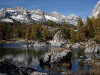
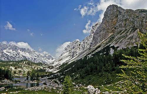
Ascending by Bela skala, the marked path brings us into the real Valley of Triglav Lakes. Soon after crossing the first hills we see the famous scene: Dvojno jezero (Double Lake), surrounded by larches, the hut by it, on the right the vertical west face of Tičarica and in the distance the high ridge of Veliko Špičje. I can't imagine that someone would proceed there without taking a short rest to enjoy.
After Dvojno jezero the valley becomes more open. Now on the right all the time vertical walls and long screes below them accompany us. Mala (Small) and Velika (Big) Tičarica, Kopica, Mala and Velika Zelnarica. On the other side there's a broad plateau of Zgornja (Upper) Komna and far behind the ridge of Plaski Vogel and Veliko Špičje. On the altitude of 1830 m the biggest of Triglav lakes lies, called Ledvička (Kidney). The trail passes it by its east shore. We leave the last larches and the valley becomes grassy with karst rock formations among grass. The both mountain chains are coming closer, the trail ascends over a few steps and reach the upper basins of the valley, where the highest of Triglav lakes are lying. Zeleno jezero (Green Lake), Rjava Mlaka (Brown Pond), Mlaka v Laštah (Pond in Ledges) and Jezero pod Vršacem (the lake under Vršac) are the permanent ones. After heavy rains or early in spring, one can find a pond or two more. Here the valley ends on the altitude a bit over 2000 m.
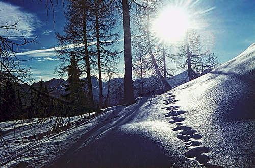 Winter in the Valley of Triglav Lakes |
 The upper part of the valley with Zelnarica |
From Komna. This is the longer, detour option, when the wall of Komarča is too dangerous. Also in summer some people prefer to descend there. If that's the decision, it is very nice to descend down to Črno jezero and from there cross towards the SW to Dom na Komni. This path goes quite close to the edge above Bohinj, offering very nice views down and across the big lake. The other path is over Lopučnica meadow. It is more suitable for coming into the Valley of Triglav Lakes, especially on skis. From Komna hut it is only 100 meters of elevation gain, but quite some ups and downs (not big ones). Nature is very nice, but the path itself can be a bit boring.
From Planina za Skalo. This is the west entry into the valley - quite a long and lonesome one. From Trenta we enter Vrsnik valley (still by car), but from there only the path goes up on Planina za Skalo, 1500 m, and then over Velika vrata pass, 1924 m, down to Lopučnica and over the last 100 m high ridge into the upper Valley of Triglav Lakes. The route only makes sense on a longer trek, or in combination with some summits in the neighbourhood.
Mountain Huts
 Koča pri Triglavskih jezerih |
|
