
-
 10222 Hits
-
 87.76% Score
-
 25 Votes
|
|
Mountain/Rock |
|---|---|
|
|
46.34133°N / 13.79080°E |
|
|
Hiking, Scrambling, Skiing |
|
|
Spring, Summer, Fall, Winter |
|
|
7611 ft / 2320 m |
|
|
Overview
The Valley of Triglav Lakes

What's New Here?
> Sep 16th, 2019: New pictures.
> Nov 17th. 2014: SP V3 layout implemented.
> 2005: Initial set up of the page.
Zelnarica Presented
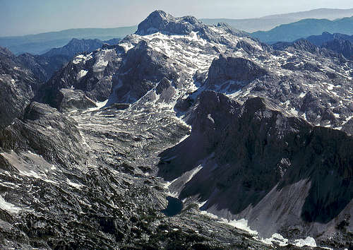
Zelnarica is one of landmarks of the Valley of Triglav Lakes. As we approach the upper part of the valley, its western wall starts rising above Veliko jezero, the biggest of lakes, until, from the path to Hribarice plateau it shows its famous tilted cone profile. So, the mountain is in every respect similar to others, rising above the valley. Giant natural forces have been pushing these young sediment (limestone) mountains over a little older plateau, which, despite showing several karst phaenomena, on some places also holds water, forming a set of beautiful lakes. All walls of Mala Tičarica, Velika Tičarica, Kopica, Mala Zelnarica and Velika Zelnarica are almost vertical, while the opposite side is in most cases much less steep.
So, there are two summits of Zelnarica. The northern one is called Velika Zelnarica (2320 m) and the southern one is called Mala Zelnarica (2310 m). In some older maps the altitudes are also reverted.

Mountains above the Valley of Triglav Lakes
Despite a nice looking wall, Zelnarica is not a climbing polygon. Its rocks are not solid enough. The majority of mountaineers ascend the summit if chosing not to go through the Valley of Triglav Lakes, but through the parallel valley Za Kopico (=Behind Kopica) instead. From the marked path there, to be precise, from Vrata, the saddle between Zadnji Vogel, 2327 m and Zelnarica, 2320 m, there's only a short jump to the summit. Also mountaineers, coming up from Bohinj alpine meadows, might choose this peak as one of the last, which can still be reached in a one day hike. And the same holds true for tour skiers. The ski tour from Zelnarica to Planina Jezero and further down in Bohinj is in good conditions among the most beautiful ones in Bohinj mountains.
 West wall West wall |
 From the south From the south |
 From the north From the north |
Summit panorama
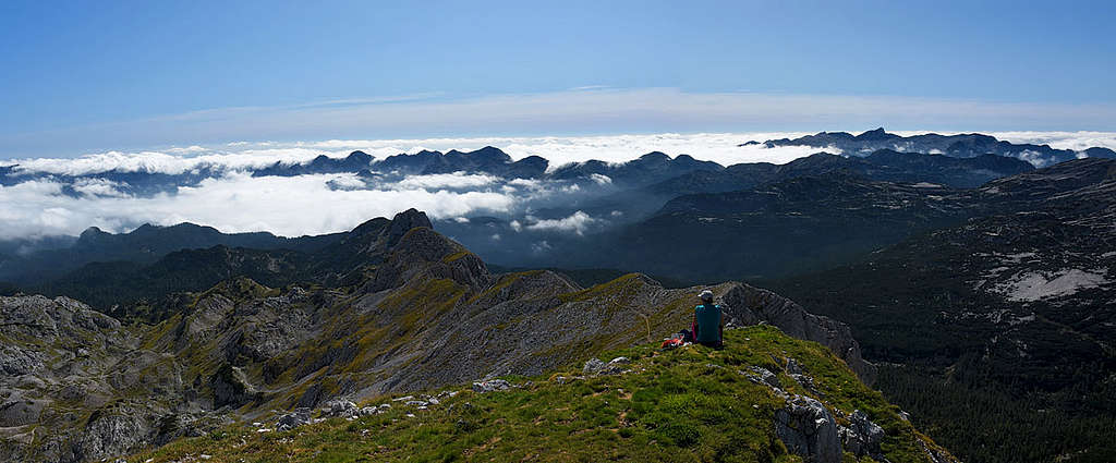
The view from the summit is specific and nice. The most attractive is to look down on blue eyes of Triglav lakes. Beyond the valley a vast Komna plateau stretches and from the summit of Zelnarica you can see all mountain chains above it: The Lower Bohinj Chain, Veliko Špičje chain and in distance the Krn group. Towards the other side the view is a bit obscured with other, a little higher mountains of the Bohinj group: Vogli, Debeli vrh, Vršaki. But Triglav is seen, together with Kanjavec, left of it.
Routes Overview
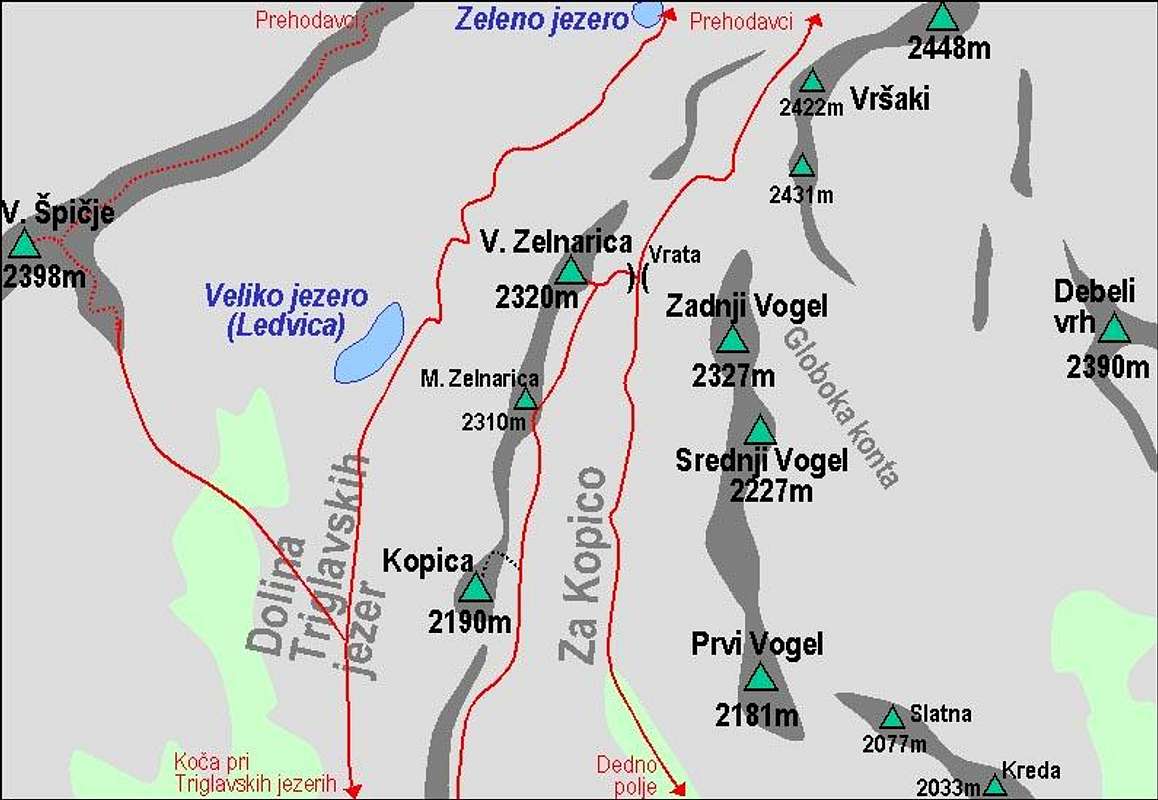
A self-made map of Zelnarica and its routes
For a broader overview see the Bohinj Group page!
How to reach Koča (hut) pri Triglavskih jezerih and Prehodavci (hut) see the 7 Triglav Lakes Valley route on the Triglav page - sections 1 and 2!
How to reach the Planina Jezero (hut) see the Bohinj Group page, section Camping & Huts!

Zelnarica summit

In the Valley of Triglav Lakes
1. Through the Valley of Triglav Lakes. Either ascending by the valley or descending from Hribarice, or coming from Prehodavci pass (hut), we must reach the crossroad on half of the slope towards Hribarice. There we turn southwards, cross the slope below Vršaki, ascend to Vrata, 2192 m (the saddle between Zelnarica and Zadnji Vogel) and in western direction to the highest point. Not marked on Velika Zelnarica (northern summit), marked on Mala Zelnarica (southern summit).
From the Koča pri Triglavskih jezerih (hut) some 2 h 30 min, from Zasavska koča na Prehodavcih 1 h 15 min. The path is marked, only the slopes below Vršaki are quite steep (scree) and the summit ascent is also steep (some 30 degrees). All in all it's an easy hike. This route can be done also in times of tour skiing. When under snow, the slopes below Vršaki are steep and demanding. As they are oriented towards the west, they are usually hard in the morning and require a full winter equipment (ice axe, crampons). Also skiing is usually done on the other side, through Za Kopico valley.

On Dedno polje

On Planina pri jezeru

2. Through Za Kopico valley. This valley, running parallelly with the Valley of Triglav Lakes is very different from the latter. It is dry, no water source can be found there and on both sides the slopes are only moderately steep. Below, it begins on Dedno polje alpine meadow, 1560 m. This nice pasture can be reached from many sides. There four paths are crossingthere: from the west comes the path from Ovčarija pasture (and from the valley of Triglav Lakes), from the south comes the path from Planina Jezero (there's a mountain hut), from the east comes the path from Planina Laz and towards the north goes a path into Za Kopica valley.
So, from Dedno polje we first ascend over a steeper lower part of the valley, until we pass Kovačičeva glava and reach a small basin between Tičarice and Vogli. We continue towards the NW, pass the flat part and start ascending moderately again. The valley gets the northern direction and becomes more and more narrow. So we comfortably reach the Vrata pass, 2192 m and in next 15 minutes the summit of Zelnarica. It's two summits - Velika on the north and Mala on the south. The marked path goes only on the southern summit, being approximately of the same altitude. From Planina Jezero hut 2 h 30 min, from the parking place at the end of the Suha road 3 h 45 min, from Bohinj valley (Stara Fužina) some 6 h+. This is also a nice ski tour. Only the summit slope is quite steep and requires a careful ascent/descent when snow is hard or slopes are icy.
3. Encircling Za Kopico Valley is another proposal for a nice one-day route, combining #1 and #2.
Almost no one reaches Zelnarica from the east. It would be possible to cross from Hribarice plateau the eastern slopes below Vršaki to Zadnji Vogel. Or, to reach Zadnji Vogel from the big karst plateau behind Debeli vrh. But there is one deep basin, called Globoka konta and only e few have experience where to get out of it on Vogli ridge.
Getting There
Bohinj Group
Julian Alps
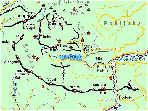
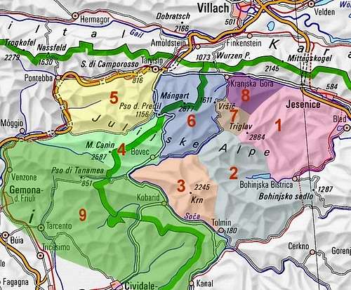
For a broader overview see the Bohinj Group page and the Julian Alps page!
On the map on the right you can see that all roads end in the Bohinj valley. The mountaineering trail for the Valley of Triglav Lakes starts at Savica, 653 m, the trail for Planina Jezero starts in Suha valley, 1150 m or below in Voje, cca 700 m.
Red Tape
Zelnarica stands in the Triglav National Parc. So, please do everything to preserve nature!
Almost all parking places around Bohinj lake need to be paid. Also the road through Suha valley needs to be paid (12€ in 2019).
When To Climb
Zelnarica can be ascended in almost all seasons. Only in hard winter condition the ascent is not recommended. So, in snow-free times the best months are June to October in times of tour skiing March to May.
For weather see here. Even better site is wunderground - here's the direct link to Kredarica station, 2515 m (below Triglav summit).
Huts and Camping
- Koča pri Triglavskih jezerih, 1685 m.
- Zasavska koča on Prehodavci Pass, 2071 m.
- Koča pri Savici, 653 m, (050) 622695.
- Koča na Planini pri Jezeru, 1453 m, (041)901 999, (050) 632738.
- Kosijev dom na Vogarju, 1054 m, (01)2912297, (050) 613367.
- Dom v Vojah, 690 m, (04) 57 23 213, (051) 308 959.
For ascents and more details see the Bohinj Group page.