
-
 17008 Hits
-
 76.27% Score
-
 7 Votes
|
|
Trailhead |
|---|---|
|
|
Los Angeles |
|
|
Spring, Summer, Fall, Winter |
|
|
3470 ft / 1058 m |
Overview: Gateway to Three Popular Peaks
This is a popular trailhead nestled between Clear Creek Junction and Red Box Gap along the Angeles Crest Highway in the front range of the San Gabriel Mountains. There is a single trail going out of this trailhead and it heads northerly up beautiful Colby Canyon on a 2.2-mile route to Josephine Saddle. The trailhead was closed for a time following the devastating 2009 "Station" fire, but is now back in use, minus the signage seen in the picture.

Destinations from trailhead

Ample parking at the trailhead
If you turn left at Josephine Saddle, you will be heading towards Josephine Peak (5,558’). From the saddle, in ½ mile you pass the point where the Josephine Fire Road intersects the trail, and then it’s 1 and ½ miles more heading northwest to Josephine Peak. A round-trip to Josephine Peak from this trailhead will be about 8 miles with 2,100 feet of gain.
If you turn right at Josephine Saddle, you have two choices. About 25 yards from the saddle, you can pick up the use trail on Strawberry Peak’s (6,164’) west ridge to its summit, a very enjoyable route including a section of 3d Class rock.
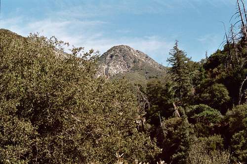
Strawberry Peak from the trailhead
Alternatively, you can continue on the Colby Canyon Trail as it winds around Strawberry’s north face and then descends into Strawberry Potrero. You will intersect the Strawberry Peak Trail 3.2 miles from the trailhead. The Strawberry Peak Trail goes south and in 1.8 miles arrives at the signed saddle between Strawberry Peak and Mt. Lawlor (5,5957’). Here, you can take Strawberry’s southeast ridge 1 mile to the summit and/or Lawlor’s west ridge less than a mile to its summit.
If you continue on the Strawberry Peak Trail past the saddle, you will arrive at Red Box in 2.3 more miles.
In short, this trailhead affords numerous options for getting to three popular front range peaks and for accessing some wonderful trails.
Driving Directions
From the 210 Freeway, exit at Angeles Crest Hwy (SR 2) and go north. At 9.5 miles, you will come to the Clear Creek Information Station and junction with Angeles Forest Highway. Continue straight for 0.8 more miles and you will spot a large dirt parking area on your left where the road is descending and begins to curve to the right. Note that the signage shown above is no longer there.Red Tape
You will need an Adventure Pass to park your vehicle anywhere within the Angeles National Forest, including this trailhead. These passes are currently sold at the Clear Creek Information Station ($5 per day or $30 for a yearly pass), which station you pass on the way to the trailhead. Otherwise, Adventure Passes are also sold at most sporting good stores in Southern California.No permits are required for hiking any of the trails accessible from this trailhead.
When to Visit
The trailhead is, for the most part, accessible year-round. However, during winter months when it snows, you may need chains to get to the trailhead.Other Information
There is usually some water in the creek as you ascend the beginning of the Colby Canyon Trail. However, without question this water should be treated if you have to dip into the creek.USGS Topos: Chilao Flat 7.5