
|
|
Mountain/Rock |
|---|---|
|
|
37.76284°N / 107.70428°W |
|
|
Hiking, Mountaineering, Scrambling |
|
|
Spring, Summer, Fall |
|
|
12734 ft / 3881 m |
|
|
Overview

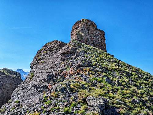
Photo by: Randy Langstraat
Located in the Northern San Juan Mountains in between the mining town of Silverton and Purgatory Ski Area, is a beautiful, almost private alpine valley accessed only .8 mile off Molas Pass. Above this valley on its eastern flank is a ridge guarded by cliffs on pretty much all sides. Turkshead Peak is the highpoint of this scrambly ridge. It resembles a knobby crag of rock only rising 234' from its proximate parent, "West Turkshead Peak." Since it rises less than 300', makes it an unranked point. However, at a rating of class 3+ perhaps even 4th, this is a super fun scramble with a short and spicy finish. Sometimes, especially in older guidebooks and manuals, this nub is referred to as East Turkshead Peak.
It is located in San Juan County, known for having some serious craggy peaks. It is also part of the Silverton quadrangle.
For an area where most of the mountains and peaks were named by miners or early Spanish missionaries, how "Turkshead" got its name is a bit of a mystery. Most features are named after people, geographically localized features (rivers, slides, lakes) or weather jargon. So Turkshead is a head scratcher. I have poured through books, history annuals and geologic assays looking for beta, but have come up with nothing. The only concrete item I've come across, is from a 1956 geologic assay detailing the morphology of the SIlverton area. In it, a photographic plate (1902) labels Grand Turk and The Sultan by name.
My guess as to why its odd name, could come from one of two possible explanations.
- Local miners to the area, probably in the 1860's or 1870's named those two prominant mountains after memories of their home countries. Turkshead Peak, a bit further to the south probably more or less adopted the same moniker. Due to its small 'cap' summit, it's certainly less 'grand' than its higher, ranked neighbor. "West Turkshead Peak" probably is named thus for the same reason...proximity.
- The cliffs surrounding Turkshead is a patchwork weave of vertical cliffs. You can distinguish various layers when you look at them. Someone probably made the jump to the world of rope and thought of a turkshead knot for its beauty of the various patterns in the weave. This is probably a bit of a stretch, but not out of the question.
Getting There
If approaching from the south:
From Durango, drive north on highway 550 (Main Avenue in town) for 41 miles. You'll gain a whopping 4,700' in elevation doing so. Crest the top of Molas Pass (10,910'), pass the rest area/viewing area on the right and proceed down the other side for .2 mile to the turn for Little Molas Lake. From the gate, drive for ~.7 mile to a wide section of the road as it briefly turns south. Park along the left side near the bushes. Other people park here as well for fishing, camping and hiking around the lake. The road past this point makes a circle around official campsites and dead-ends at a trailhead for the Colorado Trail. You COULD just park here, but it'll add a little mileage onto your day.
If approaching from the north:
From SIlverton, drive south on hihway 550 for 7.4 miles. Look for a National Forest sign detailing Little Molas Lake. Turn here (right) and start measuring from the gate. Roughly ~.7 miles up the dirt road (many potholes and washboard), the road will widen as it turns back south. Park on the left side up against the bushes. There's enough room here for perhaps 5-7 cars. Most people park here to fish the lake and picnic. Any further past this, and you run into space problems due to the camping area. The road will dead end at the Colorado Trail Trailhead (segments 25-26).
")
Route
Approach:
From the parking area along the side of the road, immediately cross the road and enter the forest. Activate your GPS track. This will come in handy for the hike out (trust me). The parking area is about 10,920'. Proceed due north (actually, about 340°) through the forest. You will steadily gain altitude. As you walk through the trees, up and over some mild hills and earthen dikes, angle slightly hikers right. There will be a rudimentary trail around 11,200' that courses up a shallow ravine. It's not necessary to follow this but it will make treking into the upper basin easier. Plus for Turkshead Peak, it puts you on the proper side of the valley; so there is that!
Once above treeline, the valley floor turns into a carpet of skunk cabbage and wildflowers. In the summer, it's actually quite beautiful. In the upper valley, you can barely see the narrow couloir you need hikers right. Switchback up the slope towards the bottom of the couloir. The terrain is a mix of tundra, dirt/scree, rock and some low bushes.
The bottom of the couloir/gully is the widest part. From here, the terrain switches to 3rd class. It doesn't really matter what side of the gully you start climbing but the right side will be easier as it continues up while the left side will steepen and turn into the left wall.
Scramble:
Keep climbing the center of the gully on alternating terrain of solid rock and scree covered dirt. The gully is varied in terms of terrain. Parts of it will be good, solid rock. Other sections will be piles of loose dirt and scree that'll slide down if you look at them wrong. The left side of th gully is verticle wall. The right side is flaring rock but the small holds are covered in kitty-litter scree. Fortunately, the gully is so narrow, it's easy to grip both sides and walk up.
The center of the gully is fairly stable and clean rock. It's easy to move here by staying low and ascending. The closer to the ridge, the gully starts to open up a bit and the surface becomes very loose dirt. Stay in the center until you reach the ridge. The right side rock wall is too untrustworthy.
Summit Ridge:
The rating drops to second class for a short while. Leave the col and scramble right towards the summit. There's a brief rock slope then the pitch drops back down to some intermittent tundra. Walk towards the summit crag for 30 feet. The final pitch is about 25' of class 3+ maybe 4th class depending on your height and comfort with exposure. It's short, perhaps only five-six moves but you really don't want to fall here. The summit is small but flat.
Red Tape
There is no red tape other than National Forest Regulations.
- Do not leave campfires unattended. ...
- Pack out and properly dispose of all trash. ...
- Cutting or damaging live trees is prohibited.
- Caching of equipment for more than 14 days is not permitted
Camping
Fortunately, there are many camping options to be had at Molas Pass. Other than the following two links, there are multiple pull-outs along highway 550 both sides of Molas Pass to utilize. About .3 mile north of Little Molas Lake (towards Silverton) on the east side is the Molas Pass/Colorado Trail Section #24 trailhead. This dirt lot is large and spread out.
There is also another large pull-out on the south side of the pass, about .3 mile that would also work quite well. It's big enough that semi's use it once in a while.

External Links
Uncover Colorado- Molas Pass
Durango Trail- Molas Pass Trails
All Trails- Colorado Trail Segment 24