

-
 13584 Hits
-
 87.31% Score
-
 24 Votes
|
|
Area/Range |
|---|---|
|
|
46.48610°N / 9.54025°E |
|
|
Hiking, Mountaineering, Sport Climbing, Scrambling, Skiing |
|
|
Spring, Summer, Fall, Winter |
|
|
11129 ft / 3392 m |
|
|
1 - Overview
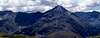
 Piz Platta, Piz Arblatsch and Piz Forbesch seen from Piz Mitgel (Sebastian Hamm) Piz Platta, Piz Arblatsch and Piz Forbesch seen from Piz Mitgel (Sebastian Hamm) |
The Platta Group is located in the Swiss canton Graubünden / Grison / Grischun. The range belongs to the Rhaetian Alps, which again are part of the Eastern Alps. The Platta Group is the westernmost subgroup of both greater ranges. Also, its southern main ridge is part of the Alpine main ridge, the watershed between rivers fowing north and south. Other names for the Platta Group are Oberhalbstein Alps (Germany) or Platta Alps and Avers Mountains (Switzerland). Naming patrons are the highest mountain, Piz Platta (3392m), the general name of the region, Oberhalbstein, and the village Avers in its western centre.
Unlike other areas in Graubünden / Grison / Grischun the rhaetoromanic language is only spoken by a minority in the Oberhalbstein Area. In the west, along the Hinterrhein River, German is the official language and you have to visit the sections near the Albula and Julia Rivers to enter rhaetic territory. In the southern part, south of Splügenpass, Italian is the majority language. Thus, in the summit listings below you will find a mix of names and occasionally a mountain with several names.
 |  |  |
The Platta Group is one of the source areas of the Rhine River, one of Europe's largest and most important rivers. The official source is elsewhere (beneath Rheinwaldhorn in the west, but the eastern branch of the river with many of its tributaries springs here. Hinterrhein, as it is called, is the western boundary of the Platta Group. The northern and eastern boundaries are formed by the Albula and Julia Rivers, while the southern and south-western boundaries are Val Bregaglia (Bergell) and Valle Spluga (Val San Giacomo).
Depending on which alpine club you want to believe (see next section) the subgrouping of the Platta Group runs up to a dozen subgroups, some of which consist of only a handful of mountains. The general elevation of the principal summits differs between some 2700m and 3300m with Piz Platta taking the crown at almost 3400m. Thus the Platta group is slightly lower than the neighbouring Albula Alps, a fact most obvious in the subgroups to the west and north. Also, the summits are more loosely separated. Long ridges only exist in a few sections.
 |  |  |
Besides Piz Platta the principal summits are Piz Forbesch (3262m) and Piz Arblatsch (3204m), Piz Timun / Pizzo d'Emet (3211m), Pizzo Stella (3163m), Piz Duan (3131m) and Gletscherhorn (3107m). The mountains are distributed all across the southern, central and eastern sectors of the group.
Like its neighbours, the Platta Group has a lot of historical significance. Many of the passes throughout the group have been in use since (at least) Roman times. Today, Splügenpass is the only road pass to the west of the group. All other passes, like Septimerpass in the east can only be travelled on foot. Most significance have the passes which lead to Val Bregaglia from the north.
 |  |  |
The Platta Group also contains the highest village of Switzerland, the Alps and all of Europe. At 2126m Juf is inhabited all year round. It's record is contested by Trepalle, however, a village south of Livigno, which boasts some houses above the general elevation of Juf.
2 - The Platta Group on SP
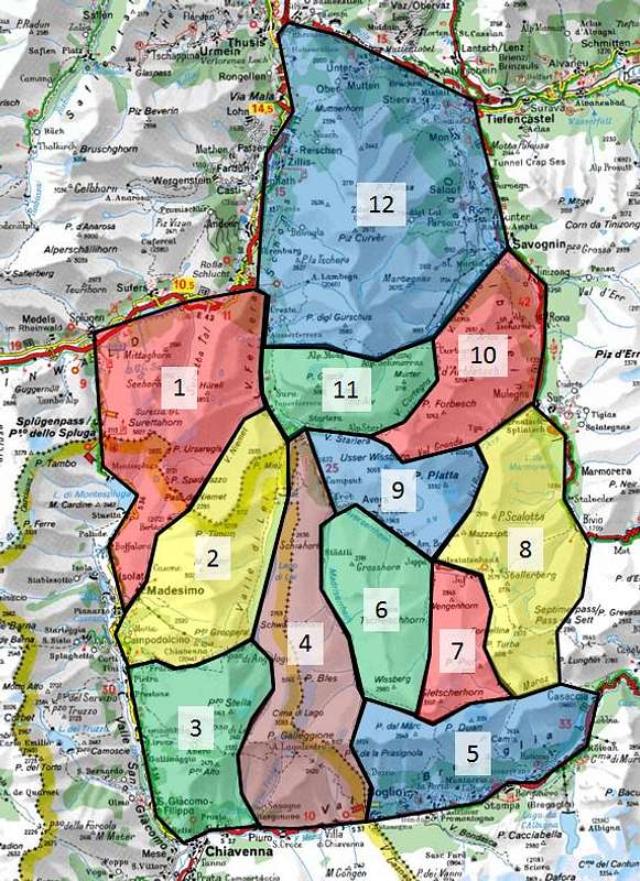
The subdivision of the Platta Group into subgroups follows the classification of the German and Swiss Alpine Clubs (DAV, SAC). The Italian Alpine Club (CAI) a slightly different subdivision with fewer but latger subgroups. In general all subdivisions follow the same boundaries.
In addition there is the Valle Spluga Page which deals in part with the Italian part of the Platta Group.
3 - The Summits
  |
3.1 - Suretta Group
- Piz Spadolazzo (2720m)
![]()
- Punta Levis (2692m)
- Pizzo della Casa (2523m)
![]()
- Pizzo Orsareigls (2833m)
- Piz Por (3028m)
- Piz Muttala (2960m)
- Hüreli (2854m)
- Punta Adami (2978m)
![]()
- Surettahorn / Pizzo Suretta (3027m)
![]()
- Cime Cadenti (2989-3021m)
![]()
- Inner Schwarzhorn (2984m)
![]()
- Mitter Schwarzhorn (2838m)
![]()
- Äußere Schwarzhörner (2890m)
- Rothörnli (2754m)
- Seehorn (2762m)
![]()
- Mittaghorn (2561m)
- Nesslabüel (1852m)
- Rosschopf (1710m)
- Schwarzwaldchopf (1650m)


3.2 - Piz Timun / Pizzo d'Emet Chain
- Cimalmotta (2834m)
- Pizzo del Crot (2846m)
- Pizzo della Palù (3179m)
![]()
- Guglie d'Altare (3178 m)
- Piz Timun / Pizzo d'Emet (3211m)
![]()
- Pizzo di Sterla (2946m)
![]()
- Monte Mater (3022m)
![]()
- Monte Caruga (2865m)
- Cresta di Crap Neger (2847m)
- Montesel dell’Alpesella (2576m)
- Pizzo Groppera (2948m)
![]()
- La Colmenetta (2345m)


3.3 - Pizzo Stella Group
- Pizzo Peloso (2780m)
![]()
- Il Dente (2805m)
- Lo Stellino (2896m)
- Pizzo Stella (3163m)
![]()
- Pizzo Somma Valle (2813m)
- Pizzo Alto (2479m)
- Motto del Piano (2314m)
- Pizzo Giardiella (2091m)


3.4 - Schiahorn - Piz Gallagiun Chain
- Cima di Colle Scengio (2421m)
- Schiahorn (2636m)
- Russa (2726m)
- Cima di Pian Secco (2769m)
- Cima di Pian Vacca (2863m)
- Schwarzseehorn (2862m)
- Piz Bless (3046m)
- Pizzo d’Inferno (3063m)
- Cima della Souvrana (3016m)
- Pizzo Rosso (3052m)
- Cima da Lagh (3083m)
- Madrisberg / Pizzo Madris (2690m)
- Pizz Gallagiun / Pizzo Galleghione (3107m)
3.5 - Piz Duan Group
- Pizzun (2966m)
- Piz da Cävi (2846m)
- Piz dal Märc (2948m)
- Piz Duan (3131m)
![]()
- Piz Cam (2634m)
- Pizzi di Maroz (2599m)
- Piz Lizun (2518m)

3.6 - Tscheischhorn Chain
- Wissberg (2980m)
- Tscheischhorn (3019m)
- Cima di Camutsch (2904m)
- Chlin Horn (2869m)
- Chlin Hüreli (2789m)
- Grosshorn (2781m)
- Hougrätli (2485m)
3.7 - Gletscherhorn - Piz Piot Chain
- Gletscherhorn (3107m)
![]()
- Pizzo Predarossa (3083m)
![]()
- Piz Mungiroi (3045m)
- Piz Piot (3053m)
![]()
- Grauhörner (3012m)
- Wengahorn (2883m)


3.8 - Piz Turba - Piz Scalotta Chain
- Piz Mäder (3001m)
![]()
- Piz Turba (3018m)
![]()
- Sur al Cant (2848m)
- Mot Scalotta (2560m)
- Uf da Flüe (2774m)
- Piz Surparé (3078m)
![]()
- Crap da Radöns (2366m)
- Piz Scalotta (2992m)


3.9 - Piz Platta Group
- Foppaspitz (2697m)
- Mazzaspitz (3164m)
![]()
- Jupperhorn (3155m)
- Tälihorn (3164m)
- Piz Platta (3392m)
![]()
- Inner Wissberg (2948m)
- Mitter Wissberg (3002m)
- Unter Wissberg (3053m)
- Hüreli (2762m)
- Grimsla (2652m)
- Cucalner (2535m)


3.10 - Forbesch – Ablatsch Group
- Piz Cagniel (2970m)
- Piz Forbesch (3262m)
![]()
- Piz Arblatsch (3204m)
![]()
- Piz Spegnas (2620m)
- Piz Arlos (2697m)


3.11 - Piz Grisch Group
- Murter / Piz Mez (2718m)
- Piz Alv (2855m)
- Piz Settember (2728m)
- Piz Grisch (3060m)
- Piz la Mazza (2815m)
- Piz Starlera (2735m)
3.12 - Piz Curvér Group
- Nölla (2641m)
- Piz digl Gurschus (2844m)
- Sur Carungas (2829m)
- Piz Cartas (2712m)
- Piz Bovs (2631m)
- Piz Martegnas (2681m)
- Piz Curvér (2972m)
- Curvér Pintg da Neaza (2721m)
- Piz Neaza (2626m)
- Curver Pintg da Taspegn (2731m)
- Piz Toissa (2657m)
- Muttner Horn (2401m)
4 - Getting There
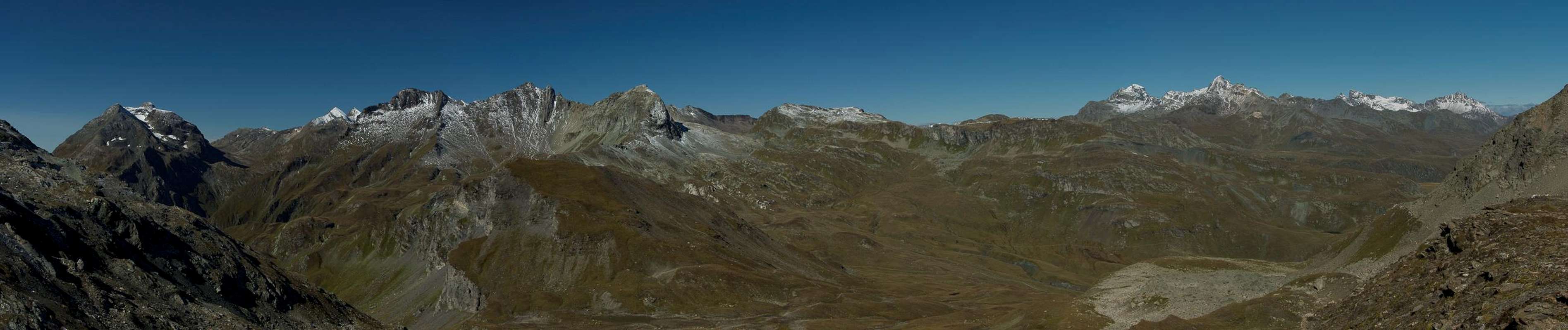
 Platta Group seen during the ascent of Piz Mitgel (Nikman)
The Platta Group can be reached most easily from the west, as the San Bernadino Route follows the western boundary of the group for most of its length. Northern access also starts from the San Bernadino Route while southern and especially eastern access are more complicated.
- Western Access (Switzerland, Germany):
- Either take motorway A3 from Zürich or A13 from the Swiss - German - Austrian border near Bregenz.
- Both combine south of Liechtenstein and lead (A13) to Chur, Splügen and San Bernadino Pass
- Take the exit Sils for the northern and eastern part of the range, any exit between Sils and Splügen for the west, Splügen for the south.
- Either take motorway A3 from Zürich or A13 from the Swiss - German - Austrian border near Bregenz.
- North-Eastern Access (Austria):
- Take A12 (Inntalautobahn) to the exit Landeck.
- Switch to B180 and after Pfunds cross the Swiss border.
- Stay on B27 through Engadin until you reach Bever, Silvaplauna, Maloja for Albulapass, Julierpass or Malojapass.
- Take A12 (Inntalautobahn) to the exit Landeck.
- South-Eastern Access (Italy through South Tyrol):
- Take Brenner Motorway A22 to the exit Bozen / Bolzano Sud.
- Switch to SS38 and pass Meran / Merano to drive through Vinschgau / Val Venosta.
- At Sponding / Spondinga turn onto SS40 to Schluderns / Sluderno
- Switch to SS41 through Glurns / Glorenza to the Swiss border.
- Stay on B28 across Ofenpass / Pass dal Fuorn until you reach Zernez.
- Drive south for the pass roads which lead westward (see above)
- Take Brenner Motorway A22 to the exit Bozen / Bolzano Sud.
- Southern Access (Italy)
- Take SS37 through Chiavenna and Val Bregaglia to Malojapass
- Alternatively take SP41 from Chiavenna through Valle Spluga Splügenpass or .
- Take SS37 through Chiavenna and Val Bregaglia to Malojapass
5 - Accommodation
 Chapel of Avers Cresta (Mathias Zehring)
- Val Albula / Val Gelgia accommodation
- Rheintal accommodation
- Valle Spluga accommodation
- Val Breaglia accommodation
6 - Red Tape
Within the boundaries of the neighbouring Platta Group and Albula Alps Switzerlands largest natural park, Parc Ela has been established. It protects the cultural, economic and natural heritage o an area where people have lived since the bronze age. Named after Piz Ela in its midst the park covers an area of 550 square kilometres, 200 of which are untouched nature. The 19 communities on its groundsupport the goals of the park and use them to attract visitors.Official Website
7 - Weather Conditions
8 - Maps & Books
8.1 - Maps
8.1.1 - Digital Maps
8.1.2 - Swisstopo Maps
- 1:50000
- LK 268 T: Julierpass
ISBN: 978-3302302683
- LK 258 T: Bergün / Brauvogn
ISBN: 978-3302302584
- LK 267 T: San Bernadino
ISBN: 978-9602125298
- LK 257 T: Safiental
ISBN: 978-9602125014
- LK 268 T: Julierpass
- 1:25000
- LK 1276: Val Bregaglia
ISBN: 978-3302012766
- LK 1256: Bivio
ISBN: 978-3302012568
- LK 1236: Savognin
ISBN: 978-3302012360
- LK 1275: Campodolcino
ISBN: 978-3302012759
- LK 1255: Splügenpass
ISBN: 978-3302012551
- LK 1235: Andeer
ISBN: 978-3302012353
- LK 1215: Thusis
ISBN: 978-3302012155
- LK 1276: Val Bregaglia
8.1.3 - Other Maps
- Oberendagin / Alta Engadina
1:40000
Kompass Verlag
ISBN: 978-3850269094
- Valchiavenna - Val Bregaglia
1:50000
Kompass Verlag
ISBN: 978-3850266949
8.2 - Books
- Bündner Alpen 6
Manfred Hunziker
Sac Schweizer Alpenclub
ISBN: 978-3859021877
- Chur - Hinterrhein
Rudolf Weiss, Siegrun Weiss
Rother Verlag
ISBN: 978-3763341856
- Skitouren Graubünden Süd: Oberhalbstein / Albula / Davos / Engadin
Vital Eggenberger
Sac Schweizer Alpenclub
ISBN: 978-3859023017
In Memory of Cyrill Rüegger
 A note from the SP staff
Cyrill Rüegger, the member we all used to know as Cyrill and Digitalis, died on June 13th 2009 in an avalanche on the summit ridge of Piz Palü together with his wife Tanja and a common friend. They were swept down by the avalanche into a couloir underneath the east summit and died instantly. Their bodies were retrieved from the Palü Glacier by helicopter a day after the accident.
Cyrill joined SP in March 2006 and soon was one of the most prolific contributors on the site with almost 70 mountain and 5 range pages to his profile. He was an accomplished climber, bagging almost 1000 summits in not quite seven years. Among them are 35 4000ers and 272 3000ers, almost all of them in his home country Switzerland.
While contributing a lot on SP, Cyrill's real internet home was www.hikr.org where he contributed 585 mountain profiles and reports in his native language German. Cyrill also posted on www.bergsteigen.at and other climbing sites, often under his real name but also under the pseudonym Digitalis. He was a botanist by profession and also contributed his knowledge about medical plants to different websites. Cyrill will be greatly missed by all.
This page will be kept in honour of Cyrill, one of SP's most prolific members and most active mountaineers.
Rest in peace, brother!
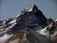
The picture above was taken on the summit of Matterhorn on July 28th 2007.