-
 13072 Hits
-
 76.66% Score
-
 7 Votes
|
|
Mountain/Rock |
|---|---|
|
|
27.12741°S / 68.48486°W |
|
|
Hiking, Mountaineering, Scrambling |
|
|
Spring, Summer, Fall, Winter |
|
|
20079 ft / 6120 m |
|
|
Overview
(Cerro) Medusa, like many of the other peaks in the Puna de Atacama, is basically just a lump emerging out of the altiplano desert and very much a non-technical ascent. That said, the weather, remoteness, and altitude of the area are all quite formidable. Medusa is a volcano, although I would assume it to be dormant or extinct -- I certainly did not smell anything while on it (in contrast to Ojos del Salado). It is just adjacent to Ojos del Salado and only a kilometer or two away from the base camp used to attack OdS from the Argentinian side, making it a perfect acclimatization peak that might take half a day to get up, down, and back to camp.Name Confusion
There is much confusion regarding the name and location of Volcán del Viento and Cerro Medusa. Which is which?
The short answer: Volcán del Viento is south of El Arenal, Cerro Medusa is to the north.
The long explanation: The confusion can be sourced to the otherwise top-rate Alpenvereins map of the area. It incorrectly IDs Cerro Medusa as "Volcán del Viento" and does not label Cerro Medusa. We know this is incorrect for two reasons:
1. Witold Paryski, who, along with three other climbing companions, put up the first ascent on Volcán del Viento, clearly places the mountain south of the El Arenal basin and south of the Argentina-Chile border on his 1956 Polish Mountaineering Club map of the region (scanned image imbedded). Since he was the first guy to climb the volcano, he should well know where it is!
2. While the titulary provenance of Cerro Medusa's is unclear, Jill Neate's authoritative Mountaineering in the Andes describes Cerro Medusa as being "S.of Nev.del Muerto, above Laguna Medusa" (Neate's note is on pg. 10 of the .pdf [see previous hyperlink] and on pg. 155 of the book). This pretty much settles things, positively IDing Cerro Medusa as being above/north of the little lake adjacent to El Arenal and leaving Volcán del Viento below/to the South of the lake and El Arenal.
This second map Google Earth map is a nice 3D representation that correctly labels both Volcán del Viento and Cerro Medusa as well as the other nearby peaks (map created by Janne Corax).

This matter could not have been settled without the help of John Biggar, Eberhard Jurgalski, and Janne Corax -- please see the credits section.
(This section is cross-posted to the Volcán del Viento SummitPost page.)
Getting There
Medusa is a border peak and like the other border peaks in this particular area of the Puna, it is much more easily approached from the Chilean side. I climbed it, however, from the Argentinian side and its approach is identical to the approach for Ojos del Salado (or Walter Penck, Nacimento, El Muerto, etc.). Below is the "Getting There" section from the Corax's superb SummitPost write-up on OdS (with some additions thrown in by me):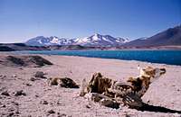
Argentina:
La Rioja and Catamarca are the two major cities in the region and both are the capitals of provinces with the same name. When in either city look for local transport to Tinogasta or Fiambalá. Most buses only go to the former and you may have to transfer buses to get to the latter, which is the perfect base for Medusa. If you arrive late in Tinogasta and there are no more buses, shared taxis runs until very late and even if you have to rent one for yourself, it's inexpensive at USD$10 for the 50-55 km ride.
All the most basic food items (pasta, Parmesan, etc.) are to be found in Fiambalá, although the minimercados obviously do not cater to the limited climbing clientele that comes through town, so for higher quality food options (granola, oatmeal, dried fruit) buying food in Mendoza, Catamarca, La Rioja, or another larger town/city is an excellent idea. For every other logistical concern, though, go through Mr. Jonson Reynoso, who operates out of Fiambalá and knows the Puna better than just about anyone else. A 4x4 vehicle and driver can be hired with a day's notice and will take you for a two-hour ride on good asphalt to Refugio Cazadero Grande, a hut along the main road (alternatively, you can hitchhike - the pickup rate is astronomical, although there may only be 10-20 cars going through the road/pass on any given day). This refugio is a good place to spend a day or two, if you're not acclimatized. The 4x4 can take you another 10-12 km on a bumpy path until you hit the Cazadero Grande River Canyon, or you can walk it.
Most expeditions make arrangements with muleteers (arrieros) to take over from here and extremely few have done the trek towards the peak unsupported. For the first day there is plenty of water to Agua Calientes, the source of the river, which is a spring with lots of warmish water oozing out of the ground. There are good camp spots all along the way and plenty of curious llamas and vicuñas. The next day's trek to Agua de las Vicuñas is a dry and windy walk over wide plains, where Nacimiento and Incahuasi dominate the horizon. You want to carry plenty of water with you on this stretch as there is *no* running water after Agua Caliente and the first penitente fields (read: snow, thus water) usually appear around Agua de las Vicuñas -- a distance of about 23 km. If you hurt yourself badly, you want to have enough water to do whatever you might need to do, otherwise you're in quite a bind. Also, it can be easy to become disoriented in this stretch as there are many small winding valleys throughout the plain that are just deep enough to obscure your view of the surrounding terrain.
After Agua de las Vicuñas the going gets steeper and tougher on loose scree and the rough path finally takes you to a pass called Portezuelo Negro at 5500 m. In this area there is much more water. Penitente fields, small glaciers, and sometimes even running water in a small creek are easy to find. From here it's hard to make a mistake where to go as Ojos del Salado, Medusa, and the other high peaks in the range are visible almost all the time. Many expeditions use a small camp called El Arenal (approximately: "The Sands") as a base camp.
From El Arenal, Medusa will be the peak nearest camp (in a somewhat conical volcano form), only a kilometer or two away. You literally just walk towards it and then up it. There's a nice little summit crater lake at the top that may or may not be frozen over and the view is positively spectacular!
Chile:
The normal starting point is the city Copiapó. Many tour operators are located here and the journey from Copiapó to Laguna Verde takes five to six hours on mostly good roads. If not acclimatized it´s a good idea to make an acclimatization stop at Laguna Santa Rosa at 3,600 m before continuing to Laguna Verde, which is at 4,400 m. There is a police post here and they want to see your climbing permit before you´re allowed to go further. A rough road will take you to the first refugio, Atacama. From there you need to walk around the Ojos massif to the El Arenal basin and Medusa is readily accessible.
Photos showing the route, step-by-step.
Red Tape
Again, see Corax's entry on Ojos del Salado.Camping
El Arenal is the camp you generally climb out of. There's a small wind wall for one tent and a minimalist cooking area. There's a small pond (sometimes frozen over, sometimes not) only a few feet from camp, plus snow and penitentes all around. Of course, on the Argentinian side, you can camp anywhere -- El Arenal is just usually the easiest.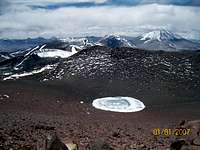
I didn't climb from the Chilean side, but as Medusa is adjacent to El Muerto I imagine it's very similar. If you've climbed Medusa from the Chilean side, please e-mail with any information about the approach!
External Links

I was originally intending to climb Ojos, but after climbing Medusa for acclimatizing purposes I ended up turning around and hiking out.
The person who probably knows the area best.
Route information, access and photos (Chilean side).
A good selection of digital and paper maps from the Military Geographical Institute.
Lists of prominent and high volcanoes and more
John Biggar's list is probably the most authoritative out there.
A scientific site about the area.
Very in depth, though, and lots of good photos.