

-
 17947 Hits
-
 86.99% Score
-
 24 Votes
|
|
Mountain/Rock |
|---|---|
|
|
47.05001°N / 11.83753°E |
|
|
Mountaineering, Trad Climbing |
|
|
Spring, Summer, Fall |
|
|
10128 ft / 3087 m |
|
|
Overview
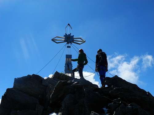
Zsigmondyspitze/Feldkopf 3089 m
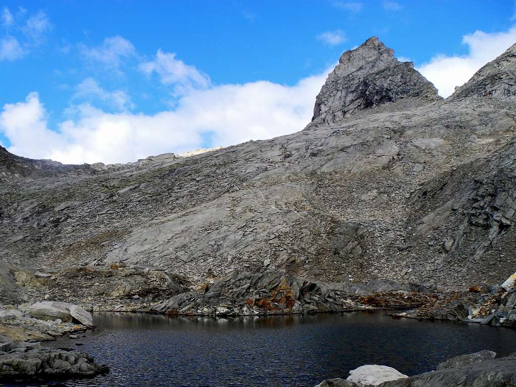
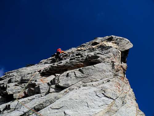
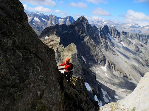
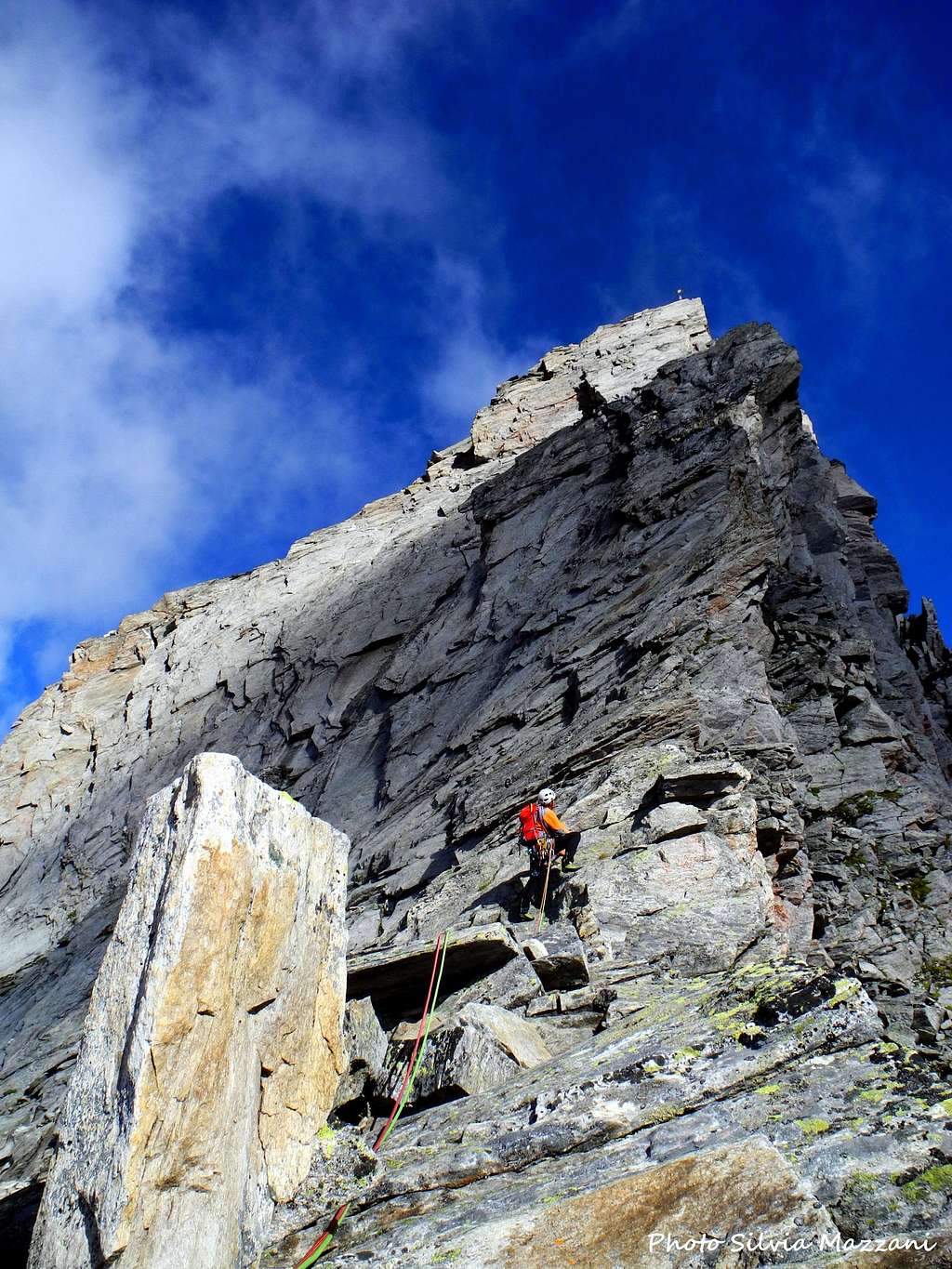
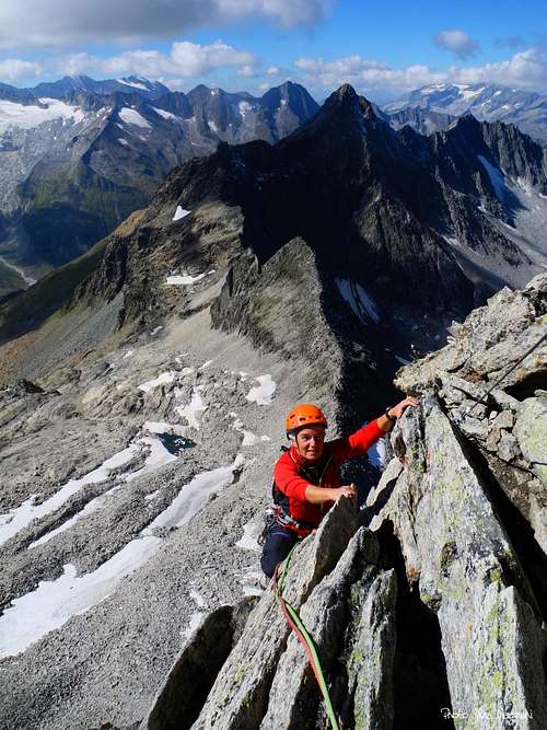
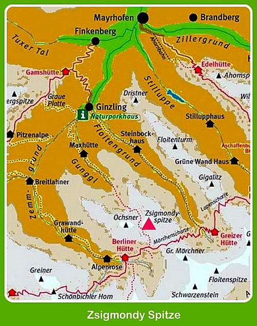
Zsigmondyspitze, also called Feldkopf, is a beautiful shaped steep summit over 3000 meters located in the middle of the Zillertal Alps, in the Austrian county of Tyrol. It is situated in Zillertaler Hauptkamm, there you'll find in Mörchenkamm. On the overview-page Zillertal Alps this mountain has the number 71, you find it on this handdrawn map. Due to its shape, Zsigmondyspitze is also called the Matterhorn of Zillertal, even if much smaller than the true Matterhorn.
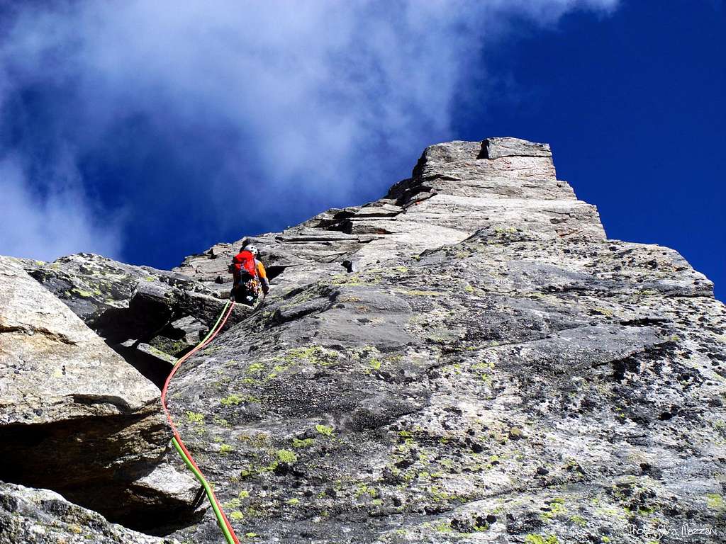
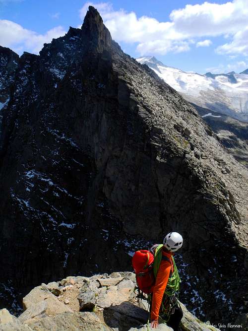
Zsigmondyspitze is a mountain for climbers only, the easiest ascent is UIAA III-. This climbing tour on the Zsigmondyspitze is an alpine granite rock classic in the Zillertal. The high-alpine landscape makes it a wonderful experience. There are some nice climbs more difficult, therefore Zsigmondyspitze is one of the most favored climbing-summits in the Zillertal Alps. The routes have good rock and are all worthwhile, although the summit is rather lonely, perhaps due to the long way to the mountain from each starting point.
History
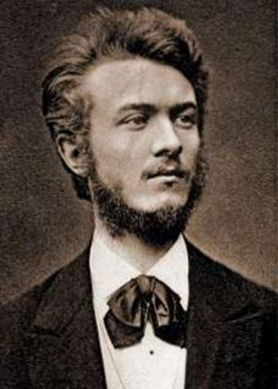
This mountain has two names and the older one is Feldkopf. Primarily it was considered unclimbable. The second name Zsigmondyspitze is dedicated to the intrepid Austrian mountaineer Emil Zsigmondy, Hungarian-born. The two Zsigmondy brothers, Emil and Otto, did the first ascent of this wonderful granite peak in 1879 via the West face. Zsigmondy was an excellent alpinist, starting his career as a teenager, climbing the Reisseck in Austria with his brother. By the late 1870s the two brothers were climbing without guides in the Zillertal Alps. In 1881, they climbed the Ortler from the Hochjoch. Emil Zsigmondy was also the friend and companion of Ludwig Purtscheller, the great pioneer of guideless Alpine climbing. The two brothers climbed with Purtscheller in 1882 and 1884, including an ascent without guides of the Marinelli Couloir on Monte Rosa and the first guideless traverse of the Matterhorn. Zsigmondy's outstanding achievements include the first ascent by the East arête of the Meije in the Massif des Écrins, made with his brother and Purtscheller in the year 1885. A few days later he died on the same mountain. He was killed in an attempt to climb the south face of the Meije on 6 August 1885. This difficult face was successively won in 1912 by Angelo Dibona and Luigi Rizzi with the brothers Guido and Max Mayer. Emil Zsigmondy's grave is located a few miles away from the accident site, in the small cemetery of Saint-Christophe-en-Oisans in the Dauphiné Alps. More info: Angelo Elli.
Getting There
The nearest town is Mayrhofen 630 m, a small town surrounded by countless peaks near the border with the Ahrntal in South Tyrol, Italy.
Road access
Coming from Italy - From Bolzano take A22 Brennero highway towards Brennero. After the pass you are in North Tyrol, go on towards Innsbruck and from there take the A13, exit Jenbach and take the Zillertal road n. 169 to Fügen, Zell am Ziller and Mayrhofen. In Mayrhofen continue on the road 169 to Ginzling (Guest House Breitlahner, paying parking). The starting point for the hike is the Gasthof Breitlahner in Ginzling, where there is also the Naturparkhaus center. The resort can be reached by the bus line 4102 or by car. Parking in Breitlahner is charged.
Alternatively you may hike through the long Floitengrund from Ginzling to Greizer Hütte (2227 m), ascend on Berliner Höhenweg to Mörchenscharte (2957 m) descend 500 m to Schwarzsee (2472 m) and finally ascend as described above.
However, the ascent is very, very long ...
If you want to conquer this mountain in only one day, you may start 1 km behind Ginzling (Rauth in about 1000 m), hike on path Nr. 522 to Melkerscharte (2814 m). 100 m below this gap you can ascend on your left to Sammerscharte and reach there the rewarding Lammergrat.
After passing the Melkerscharte you reach Feldscharte (2878 m) on the left, the normal route starting point. But also there, the route of advance is very long.
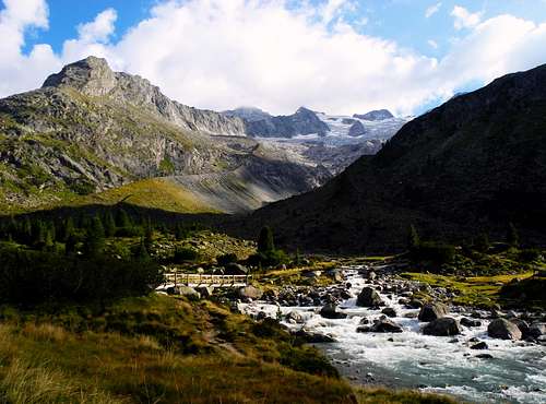
Walking approach to Berliner Hütte
From the Gasthof Breitlahner take the trail 523, which runs along the long Zemmgrund Valley. After a short steep stretch, the path enters the valley and after a mainly flat part, it slowly starts to go up, passing near the Klausenalm and Schwemmalm alps, then near the Grawandhütte refuge and the Alpenrose Hütte. Soon after this latter hut, the path head to left and after the "Memorial to the fallen soldiers" gets the refuge Berliner Hütte at 2042 m. 3-4 hours from Breitlahner.
Climbing Routes
1 - Normal route Rated III- (some sources say II+) - First ascent: A. Böhm (descent 1880), A. Katzer S. Kirchler (lower half, 1882), K. Diener, H. Stabeler (upper half, 1881)
This is the most frequented route. It's a really nice climb, sometimes a little bit aerial, good rock, a pleasure climb, when conditions are good. See more details in the route description.
Approach from Berliner Hütte - The starting point to climb is the col named Feldscharte 2909 m, between Zsigmondyspitze and Roßköpfe. From the Berliner Hütte take the trail n. 502 towards Greizer Hütte (it's a part of the Berliner Höhenweg), getting the nice Schwarzsee in about 1 hour. Leave the path n. 502 and take now the marked path 522, starting to rise to saddle Melkerscharte 2814 m. After passing another little lake and about 100 m before getting the Melkerscharte leave the main trail and exit rightward rising up along scree and snow-fields in the direction of the Feldscharte. The starting point is just from the col.
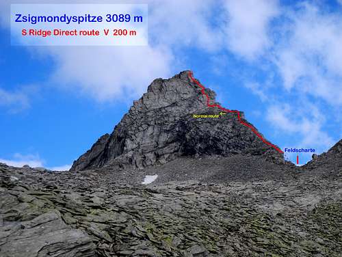
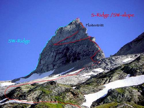
2 - South Ridge Rated V-, 200 m - First ascent: H. Fiechtl, H. Hotter (1911)
The uncommon alternative for good climbers. See more details in the route description.
Approach from Berliner Hütte - The starting point to climb is the col named Feldscharte 2909 m, between Zsigmondyspitze and Roßköpfe. From the Berliner Hütte take the trail n. 502 towards Greizer Hütte (it's a part of the Berliner Höhenweg), getting the nice Schwarzsee in about 1 hour. Leave the path n. 502 and take now the marked path 522, starting to rise to saddle Melkerscharte 2814 m. After passing another little lake and about 100 m before getting the Melkerscharte leave the main trail and exit rightward rising up along scree and snow-fields in the direction of the Feldscharte. The starting point is just from the col.
3 - South-West Face Rated III+ - First ascent: L. Sager, W. Schmidkunz, H.v.Zallinger (1926) - Another interesting alternative to the Normal route, it uses the direct line in the SW-face and crosses 2 times the normal route
4 - New South-West Face Rated V+ - First ascent: W. Frankhauser, G. Hörhager, R. Kröll, A. Hörhager (1982)
5 - South-West Ridge Rated V-/A0, 200 m - First ascent: H. Fiechtl, M. Kröll (1911) - A beautiful climb for good climbers.
6 - West Face Rated II - First ascent: E. Zsigmondy, O. Zsigmondy (1879) - The route of the first ascent, today no longer used because of danger of rockfall
7 - Lammergrat (NNW) Rated IV+ - First ascent: H. Pauksch, H. Fiechtl, G. Hauser (1909) A fantastic climb, very aerial, best rock quality, 2.30 hrs from beginning of climb.
(Ginzling - Gunggltal - 100 m under Melkerscharte left in a couloir to the ridge. Until here 5-6 hrs!)
8 - East-North-East Face Rated VI+/VII- - First ascent: J. Kröll, H. Condin (1985) - One of the most difficult routes in the Zillertal Alpes (Details see in the review "Berge" 3/2001 (text in German)
9 - North-East Face Rated V - First ascent: H. Fiechtl, H. Hotter (1910)
10 - Feldkopfkante Rated V- - First ascent: H. Fiechtl, H. Hotter (1911) - A fantastic but long and difficult climb from Floitengrund directly to the summit (ca. 1000 m!)
11 - Direct Route Feldkopfkante Rated V+ - First ascent: J. Kröll, H. Condin (1986)
Red Tape
No fees no permits required in the region of the Zillertal Alps. However, please keep in mind that this zone of Alps is a natural reserve ("Ruhegebiet Zillertaler Hauptkamm") with some limitations.
Useful information on this preserve can be found under Naturpark Zillertal.
Camping/Accomodation
Camping is possible in camping areas in the valley, but forbidden in the mountains, because the region is a biological reserve.
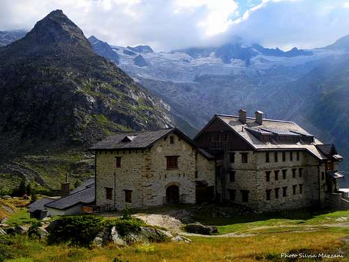
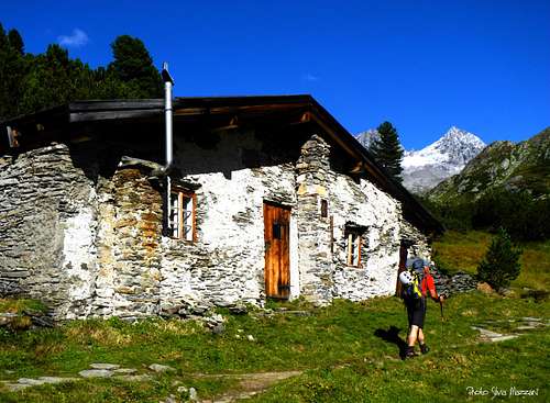
In Ginzling and Mayerhofen there are many accomodations. A good advice is to stay in Berliner Hütte (2049 m), a really jewel amongst the Alpine huts. From there it takes only 2.5 hrs. to the beginning of the climb. Advantageously combine this climb with other routes to the magnificent summits in this region.
To ascend to Greizer Hütte (2227 m) from Ginzling is another possibility to reach Zsigmondyspitze.
Huts
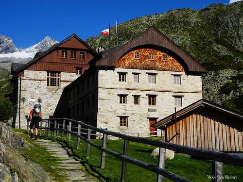
Berliner Hütte 2042 m DAV Sektion Berlin is an imposing mountain refuge
Situation: Schwarzensteinalm in the upper Zemmgrund
Owner: DAV Sektion Berlin
Guardian: Rupert Bürgler
Open: 15 of June - 30 of September
Size: 177 persons + 14 in the winter-shelter
Email: berlinerhuette@aon.at
Hut's phone: 0043 676 7051473
Getting There: from Gasthof Breitlahner in Ginzling in 3-4 hours
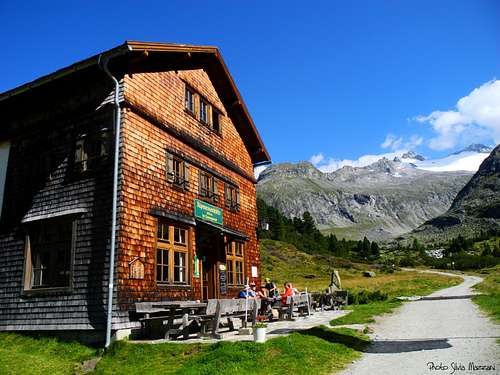
Alpenrosen Hütte 1878 m
Situation: upper Zemmgrund
Guardian: Franz Joseph Fleckl
Email: alpenrose@ginzling.com
Mobile 0043/(0)664/ 9177850
When to climb
Best season is from July to September
Meteo
Guidebooks and maps
For more information see the following excellent book (in German):
Zillertaler Alpen
Alpenvereinsführer
H. Klier, W. Klier
Rother Verlag
ISBN: 3-7633-1269-2.
This book is availablein the online-shop from Amazon.
External Links
Let me show some links to this rather lonley mountain.
The one I can recommend is the website of Günter Mitterer, a mountain guide in Finkenberg/Zillertal who led us the first time to the magnificent summits and glaciers of Zillertal Alps. On his site you will find lots of beautiful pictures and - if you want - possibilities of a professional guide in these mountains: www.bergsport-zillertal.at . The illustration of our adventures can be found there.
Information on Zillertal and its nature park are available also in English at this website.: www.zillertal.at