
-
 37444 Hits
-
 85.37% Score
-
 21 Votes
|
|
List |
|---|---|
|
|
Mountains in Banff National Park
Mount Aylmer
Routes:
South-West Slopes/Ridge
Tower of Babel
Routes:
Scramble
Fuhrmann Route
Mount Bell
Routes:
South-East Ridge
Mount Bosworth
Routes:
Scramble
Mount Bourgeau
Routes:
Scramble
Mount Brett
Routes:
Pilot traverse
Castle Mountain
Routes:
Eisenhower Tower
Cascade Mountain
Routes:
Cascade falls
Rogan's Gully
Normal Cascade Ampitheatre
Copper Mountain
Routes:
South-West Ridge
Mount Cory
Routes:
South Ridge
Dolomite Peaks
Routes:
Peaks 4 & 5
Mount Edith
Routes:
Three Peak traverse
Mount Fairview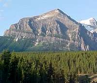
Routes:
South-East Slopes
Mount Fay
Routes:
North Face
The Finger
Routes:
Board Route
Fossil Mountain
Routes:
Fossil Mountain Ski
Helena Ridge
Routes:
Helena Ridge
Isabelle Peak
Routes:
South-East Ridge
Mount Ishbel
Routes:
South Ridge Circuit
Mount Louis
Routes:
Gmoser Route
The Mitre
Routes:
East Ridge
Mount Niblock
Routes:
Niblock Whyte Traverse
Normal Route
Mount Norquay
Routes:
Scramble Traverse
Panorama Ridge
Routes:
Ridge Traverse
Pilot Mountain
Routes:
Brett Traverse
Mount Rundle West End
Routes:
Professor Falls
Mount St. Piran
Routes:
East Face/Trail
Sheol Mountain
Routes:
South to Ridge
Storm Mountain
Routes:
South-West Slopes
Television Peak
Routes:
Stuart Knob Traverse
Mount Temple
Routes:
East Ridge
Mount Whyte
Routes:
Niblock Whyte Traverse
jimboa - Aug 29, 2013 7:06 am - Hasn't voted
Caldron PeakCaldron Peak sits just southwest of the Icefields Parkway approximately 30 minutes northwest of the Lake Louise turnoff. While I can not comment on the final ridge scramble to the summit, I thought I would at least add the peak and provide my experience on the approach. This is also documented in the book, "Don't Waste your Time in the Canadian Rockies." The main challenge of the route is creek crossings which are at least knee high. I would recommend good water shoes which will save a lot of hassle throughout the trip. Trekking poles were very helpful too. The trailhead is at the Peyto Lake overlook. Follow the paved trail to the look out where you be able to see most of the route. If you then turn your back to the lake, turn right up a different paved path, and you will quickly come to the trail which drops to Peyto Lake. Upon reaching the lake, you will likely quickly encounter areas where it becomes challenging to stay on dry ground as you enter the inflow gravel plain of Peyto Lake. It's worth changing shoes here, even though you have another 1-2 km before you reach the main creek crossings. There are several cairns that help guide you across the open gravel bed, but essentially, aim for the tree covered slope that comes down from the left as you proceed upstream. A trail begins again once you reach the trees, and will take you to the point where you re-enter the stream bed and prepare for crossing the several braids of Peyto Creek. Of course, these channels change, so just search out the place where there are several braids that appear safe to cross. The current is swift and the depth can be deceiving, so be careful. Upon reaching the other side of Peyto Creek, one can stay at the creek's edge until reaching a cliffy area at Caldron Creek, or begin a gradual traversing climb. I found the former to be better and if you keep your eyes out for it, will take you to a crude log bridge over Caldron Creek. It is relatively low to Peyto Creek, and it's easy to get too high and miss the bridge (and the subsequent trail) all together. Once across Caldron Creek, it's a fairly straight forward ascent up a moraine heading generally south, before the route gradually curves right above cliffs. Once you top the moraine, make sure to take a short side trip to the left to get the awesome view of the Peyto Glacier. The way is fairly easy to discern above the cliffs and takes you to the one other sketchy portion of the approach. This is a very narrow boot path on a steep traverse across a scree slope directly above a cliff: definitely a no fall area. Obviously, an ice axe is a must if snow is present. The boot path continues through talus and high meadow to Caldron Lake which is a fantastic destination in itself. I'll leave the continuing route description to someone else.