
-
 12759 Hits
-
 81.18% Score
-
 13 Votes
|
|
Mountain/Rock |
|---|---|
|
|
38.44030°N / 78.4156°W |
|
|
Madison |
|
|
Hiking |
|
|
3540 ft / 1079 m |
|
|
Overview
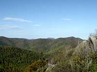
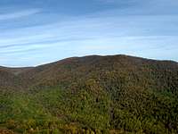
Bluff Mountain rises more than 2,500 feet from the nearby Rapidan River valley to the east. It is located on a spur off the Jones Mountain ridge, which runs off the main ridge of the Blue Ridge Mountains in the Shenandoah National Park Central District. The hike to Bluff Mountain from the valley floor follows the Rapidan and Staunton Rivers and offers spectacular views of Doubletop, Fork, and Jones Mountains from Bear Church Rock. More views are available of the Blue Ridge Mountains to the west, east, and south are available from near the summit of Bluff Mountain, but require a difficult bushwhack to reach them. Bluff Mountain is one of the more challenging hikes in this part of the Blue Ridge Mountains.
It is possible to stay at a cabin near the trail to Bluff Mountain that is rich in historical significance. In the early 20th Century, the Jones Mountain Cabin was the home of Harvey Nichols, who was a locally famous moonshiner. After the federal Government bought out all of the property in what is now Shenandoah National Park, it burned down most of the houses of the former landownders. Somehow, the Jones Mountain Cabin was forgotten until it was rediscovered in the 1960s. It was renovated by the Potomac Appalachian Trail Club and is now a popular place for hikers to spend a night or two.
Getting There
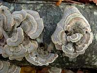
Lichens
Doubletop Mountain
Fork Mountain

Jones Mountain

Bearfence Mountain

Lewis Mountain
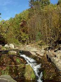
Staunton River

Moth
Graves Mill Trailhead: From Culpeper, go south on U.S. 29 for about 20 miles. South of Madison, turn right at Route 230 West. Follow Route 230 for about four miles to Wolfton. Turn right at SR 662 and follow it to its end at the Shenandoah National Park boundary.
Dismount your vehicle in the parking lot and hike for 0.5 miles on the Graves Mill Trail. Turn left at the Staunton River Trail and follow it for 2.2 miles. Turn left at the Jones Mountain Trail and follow it for 1.2 miles to Bear Church Rock. Take in the spectacular views of Fork Mountain, Doubletop Mountain, and the Jones Mountain ridge. Then continue for about 1.1 miles along the Jones Mountain Trail. When you get to a blue blaze on the trail at coordinates , this is where you turn left into the forest and start bushwhacking towards Bluff Mountain. If you don’t have a GPS with you, note that the ridge slopes down from the trail on the left side after Bear Church Rock. When you reach the point where you see uphill slopes on the left, you are looking at the ridge to Bluff Mountain.
The bushwhack starts off through open woods. Blowdowns and other obstacles can be easily avoided. However, things get considerably more interesting after about 0.3 miles. As useful as topo maps are, they can only show so much detail. The map shows that the ridge becomes considerably steeper at this point, but it does not show the elevation gain is discrete rather than continuous. In other words, it does not show the large boulders blocking the ridgeline. Circumventing the boulders on the western or eastern sides of the ridge is not quite as tricky as ascending them, but it is still difficult and dangerous. The steepness of the slopes beneath the boulders and the thick layer of leaves make it difficult to get any traction. There may be an easier route that goes closer to the boulders that I just missed.
After the boulders, regain the ridge and continue bushwhacking towards the summit. About 0.4 miles from the Jones Mountain Trail, there is an overlook below the right side of the ridge that offers spectacular views of the Jones Mountain ridge, the summit of Fork Mountain, and Bearfence and Bush Mountains. After about 0.6 to 0.7 miles from the Jones Mountain Trail, you will reach the true summit, which is fittingly a small boulder! From near the summit, views are available to the east and south. It is advisable to have a GPS on the way back to keep you from wandering off the main ridge.
Round trip: About 11.4 miles with an elevation gain of about 2,800 feet.
Skyline Drive: From Culpeper, go north on U.S. 522 until reaching Sperryville. Take U.S. 211 west from Sperryville up to the crest of the Blue Ridge. From there, exit to Skyline Drive and go south until reaching Bootens Gap, which is shortly after milepost 55. Turn left on the Conway River Road and park off the road here.
Hike north on the white-blazed Appalachian Trail for 0.5 miles and then turn right at the Laurel Gap Trail. Follow the Laurel Prong Trail for 1 mile to Laurel Gap, then continue for 0.5 miles to the summit of Cat Knob. From here, follow the Jones Mountain Trail for about 2.4 miles to the intersection of Bluff Mountain with the Jones Mountain ridge. Turn right and bushwhack to the summit.
Round trip: About 10.2 miles with an elevation gain of about 1,700 feet.
Red Tape
Entry to Shenandoah National Park is free from the boundary. The $15 entry fee is only applicable if you come in via Skyline Drive.
Critters
Caterpillars
 |
 |
 |
Other Critters
 Bug |
 Salamander Salamander |
 Turtle |
When to Climb
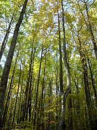
Bluff Mountain can be climbed nearly all year round. The hike can be particularly delightful in mid to late October when fall colors are at their peak; many trees below 3,000 feet elevation still have their leaves on Veterans Day. It is recommended to avoid hiking in the Rapidan Wildlife Management Area, which includes the summit of Bluff Mountain, from mid-November to New Year's Day because deer hunting with modern firearms is permitted. Summer is the worst time for mosquitoes, ticks, and other hostile little critters. The heat and humidity are also at their worst in summer.
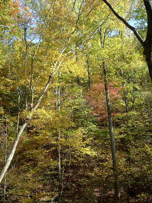
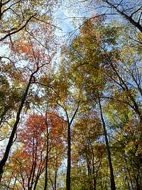
Fall Colors
Camping
The Jones Mountain Cabin can accommodate as many as 10 guests. The cabin can be reached by a side trail from the Jones Mountain Trail; the trail junction is about 0.7 miles from the Staunton River Trail and 0.5 miles from Bear Church Rock. Contact the Potomac Appalachian Trail Club for more information.
Free camping is permitted throughout the Rapidan Wildlife Management Area for up to 14 consecutive days.
Free backcountry camping is allowed throughout Shenandoah National Park. The required permit can be obtained through mail or at entrance stations, park headquarters, or visitor centers. Campfires are only permitted at pre-constructed fireplaces at backcountry huts and day-use shelters. Campsites must be at least:
•10 yards away from a stream or other natural water source.
•50 yards away from standing buildings and ruins.
•100 yards away from a hut, cabin, or day-use shelter.
•1/4 of a mile away from a paved road or park boundary.
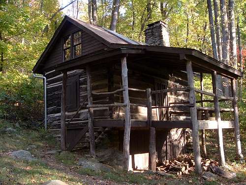
Jones Mountain Cabin
External links
Shenandoah National Park
Rapidan Wildlife Management Area
The Potomac Appalachian Trail Club rents the Jones Mountain Cabin, maintains the trails in the Shenandoah National Park, and provides maps, guidebooks, and other information.