
-
 17640 Hits
-
 81.18% Score
-
 13 Votes
|
|
Mountain/Rock |
|---|---|
|
|
38.56120°N / 78.384°W |
|
|
Toprope, Bouldering, Scrambling |
|
|
Spring, Summer, Fall, Winter |
|
|
3400 ft / 1036 m |
|
|
Overview

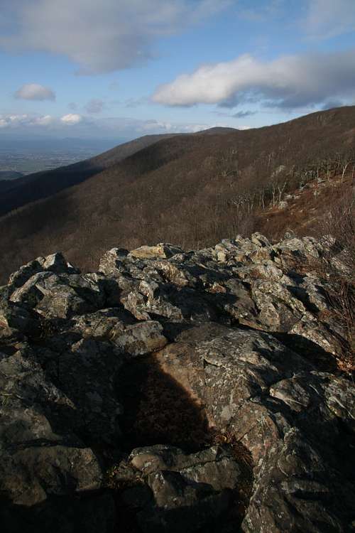
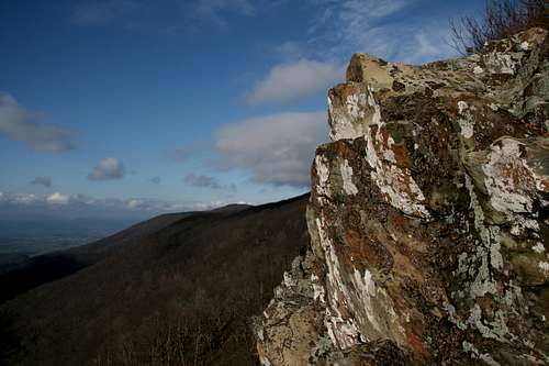
Crescent Rock is a cliff that rises about 100’ from its base, although the climbing is really in the 60-70’ range since the lower portions of the cliffs are covered with thick vegetation. Much of the crag consists of hard, ancient greenstone and a grayish-whitish rock that is pretty to look at (this might be greenstone, too, but just stained by some natural process), but the lichens covering great portions of the exposed faces can make for treacherous footing. The fragmentation of the rock provides wonderful handholds almost everywhere, and although the rock looks sketchy and actually is somewhat loose in places, it is mostly quite solid.
Crescent Rock is great for scramblers and people who are comfortable going unroped for 5.0-5.4 moves. In fact, Crescent Rock is much better for scrambling and free soloing than it is for roped climbing. The main reason is that the cliffs, though quite challenging in spots, are often broken by ledges and outcrops easily scrambled, and a roped climber will frequently be climbing sections that few people would rope up for. To put it more simply: the parts that are highly technical may not be long enough for serious climbers to bother with. The exception is the section near the northern end of Crescent Rock. There, the cliffs tend to be sheerer, and the technical stretches are sustained enough to warrant carrying and setting up the gear. Because there aren’t any established routes here that I know of and the cliff largely lacks the clean lines trad climbers like, I strongly recommend toproping if one wants to rope up here. And if one does toprope, he or she will need to bring gear for setting up the anchors, as there really are not suitable natural anchors atop the cliffs.
But for those who do like to scramble and who like to free solo on easier Class 5 rock, Crescent Rock is a delight. There are many different ways to scramble or climb from the bottom back up, and some of them stay at Class 3. Those after Class 4 and up to 5.2 will also find enough to keep them interested. There are short cracks and corners, small overhangs, tricky blocks, and exposed traverses all waiting to provide a bit of a challenge and a thrill. And there is harder stuff for those looking for it. Best of all, although there could be a few people atop the crag on a nice day, you’re highly unlikely to find yourself sharing the cliffs with other people; at the base of the cliffs, there are none of the usual tell-tale signs of popular climbing and scrambling areas.
Approaches--
Getting to Crescent Rock is very easy (see next section), but getting down the cliffs is another story entirely. Here are four suggestions:
1. Walk along the clifftops until you approach the south end. There, the cliffs become less sheer, and you can see a series of ledges offering a way down. Followed carefully, this system is Class 3. This is the descent method I recommend. I used #2 for my first approach and found it quite tedious. I used this one each time after that.
2. Scramble down the north end of the cliffs. This can end up taking you several minutes, though. You will often run into drops that only crazy people and climbing superstars would downclimb without rope, and the “easy” way down eventually gets blocked by thick stands of mountain laurel that grow out to the edge of the cliffs, forcing you to simultaneously push the shrubs back while holding onto them as you inch along the very brink of the cliffs. Finally, you will get down, but then you will have to traverse across some tricky rock and through some thick undergrowth to reach the base of the brush-free cliffs.
3. Access the Appalachian Trail from the north end of the parking lot and then hike south for maybe two or three minutes until you are beneath the cliffs. The serious downside to this approach is that you will then have to bushwhack to get to the cliffs themselves and then climb 30-40’ of vegetation-clad rock just to reach the exposed rock. Not my kind of fun.
4. If you’re roping up, rappelling down might be the easiest way to get down to the spot from which you want to start.
You can climb here in any season, but mid-spring and mid-fall are probably best because there will be less undergrowth, temperatures should be pleasant, and it won’t be buggy. Summer can be very hot and humid, and the gnats may drive you nuts. Winter can be bitterly cold up here, especially since the cliffs face west and receive almost-constant winds. A warm, sunny afternoon in any season is really the ideal time to play around on Crescent Rock.
Oh, and watch for poison ivy if you use Approach 2 or 3.
Getting There
Enter Shenandoah National Park on Skyline Drive at one of its four access points. Then drive to Crescent Rock Overlook, between Mileposts 44 and 45 (mileage is recorded in ascending order from north to south). Park at the left (south) end of the parking area. Get out and hike about one minute to the top of Crescent Rock. To access the climbing opportunities, see the section above.Note: Do not confuse Crescent Rock with Bettys Rock, the short trail to which departs from the north end of the parking area.
 The Clifftop
Red Tape
It costs $15 to enter the park, and that provides access for a week. Annual passes cost $30. The interagency pass, good for yearlong entry to areas managed by NPS, USDA Forest Service, USFWS, BLM, and the Bureau of Reclamation, costs $80.It’s common sense to wear a helmet when climbing, anyway, but it’s especially important here since people at the top might toss rocks over the edge.
The park is open all year, but Skyline Drive does sometimes close after snow or ice storms. The park site does not give current road conditions, so call ahead (540-999-3500).
To reduce poaching, Skyline Drive is subject to closures during hunting season. The information below, copied and pasted from the park site, illustrates the 2006 restrictions—
From November 13, 2006, through January 6, 2007
Skyline Drive
• between Front Royal (Mile 0 at U.S. Highway 340) and Thornton Gap (Mile 31 at U.S. Highway 211), and
• between Swift Run Gap (Mile 65 at U.S. Highway 33) and Rockfish Gap (Mile 105 at U.S. Highway 250),
will be closed daily between 5:00 p.m. and 8:00 a.m.
The central portion of the Drive, between Thornton Gap and Swift Run Gap, will remain open for overnight access to Skyland Resort and Big Meadows Campground until those facilities close on November 26.
Then, beginning November 27, 2006, through January 6, 2007, the entire length of the Skyline Drive will be closed daily from 5:00 p.m. until 8:00 a.m.
Camping and Lodging
The nearest campground is Big Meadows, about 7 miles south. The campground is usually open from early March through Thanksgiving weekend. Reservations are strongly advised. For more comfort, consider staying at Skyland Lodge, about three miles north, or at Big Meadows lodge. The lodges are seasonally open, with Skyland opening earlier than Big Meadows. See the External Links section for links to pertinent information.External Links
Official park siteCamping info
Lodging info