
-
 19407 Hits
-
 83.69% Score
-
 17 Votes
|
|
Mountain/Rock |
|---|---|
|
|
38.49550°N / 78.3976°W |
|
|
Madison |
|
|
3455 ft / 1053 m |
|
|
Overview
Doubletop Mountain in the Rapidan Wildlife Management Area and Shenandoah National Park actually has four summits. It is probably called Doubletop because of the two highest summits on the western part of the ridge. Although the routes to the true summit of Doubletop are not all that long, neither of them is easy because of the steepness of the trails. The true summit is wooded, but there are views along the way of the Blue Ridge Mountains to the north, west, and south, including Fork and Big Tom Mountains. The trails on Doubletop also allow for exploration of the summits on the eastern part of the ridge.Getting There


Wilhite Wagon Trail: From Culpeper, go south on U.S. 29 until reaching Route 231. Go north on 231 and then turn left on SR 670 towards Syria. Make another left on SR 649 and follow it to its end. SR 649 becomes Rapidan Road as it enters Shenandoah National Park. Continue on the road as it crosses a bridge across the Rapidan River, which forms the boundary of Shenandoah National Park and the Rapidan Wildlife Management Area. Shortly after the second bridge across the Rapidan River, you will see orange blazes on the right side of the road that indicate the beginning of the Wilhite Wagon Trail. Park on the left side of the road about 0.1 miles after the trailhead. If you miss the trailhead, the coordinates are 38.4815 N, 78.3954 W.
Hike 0.1 miles on the road to the trailhead. Turn left and follow the orange-blazed Wilhite Wagon Trail for 0.8 to 0.9 miles. At a fork in the trail, turn left and continue for 0.4 miles to the crest of the ridge. At the intersection with the blue-blazed Doubletop Mountain Trail, turn left. Turning right on the trail and making a side trip of about 75 feet will lead to an overlook with views of Big Tom Mountain, Spitler Hill, and other Blue Ridge peaks. The old topo map shows that the Wilhite Wagon Trail gains the ridge to the west of the false summit, but it actually does to the east of the false summit, so your climb will be longer and steeper. Hike on the trail for about 1.2 miles, making a steep ascent over the false summit of Doubletop and then the true summit. The descent after the false summit is particularly steep with a grade of about 41%.
Round trip: About 5 miles with an elevation gain of about 2,000 feet.
Doubletop Mountain Trail: From Culpeper, go south on U.S. 29 until reaching Route 231. Go north on 231 and then turn left on SR 670 towards Syria. Follow SR 670 to SR 648 and make a left. Continue on SR 648 until reaching the end of the road. Park here.
Start hiking on an old road, and then make a left on the blue-blazed Doubletop Mountain Trail. Hike up the steep trail to the summit; there is an overlook called Monkey Head along the way on the right side of the trail. From Monkey Head, views are available of Fork Mountain and other nearby Blue Ridge peaks.
Round trip: About 3.2 miles with an elevation gain of about 1,800 feet.
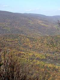
Fork Mountain from Doubletop
Red Tape
Entry to Shenandoah National Park is free from the boundary. The $15 entry fee is only applicable if you come in via Skyline Drive.When to Climb
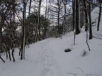
Doubletop Mountain can be climbed nearly all year round. The hike can be particularly delightful in mid to late October when fall colors are at their peak; many trees below 3,000 feet elevation still have their leaves on Veterans Day. It is recommended to avoid hiking in the Rapidan Wildlife Management Area, which includes the summit of Doubletop Mountain, from mid-November to New Year's Day because deer hunting with modern firearms is permitted. Summer is the worst time for mosquitoes, ticks, and other hostile little critters. The heat and humidity are also at their worst in summer.The Rapidan Road is a well-maintained gravel road until it reaches the first bridge over the Rapidan River. Once you cross the bridge into the Rapidan Wildlife Management Area, driving can become dicey, particularly in the winter or if you have a low clearance car. Be aware of road conditions in advance. You NEVER want to hear the sound of rock on metal even if your vehicle escapes undamaged!

Big Tom in Autumn

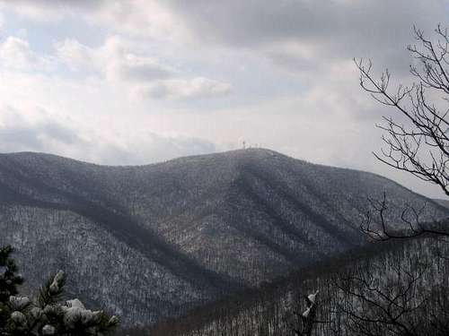
Big Tom in Winter
Camping
Free camping is permitted throughout the Rapidan Wildlife Management Area for up to 14 consecutive days. There are numerous campsites near the Rapidan Road.Free backcountry camping is allowed throughout Shenandoah National Park. The required permit can be obtained through mail or at entrance stations, park headquarters, or visitor centers. Campfires are only permitted at pre-constructed fireplaces at backcountry huts and day-use shelters. Campsites must be at least:
•10 yards away from a stream or other natural water source.
•50 yards away from standing buildings and ruins.
•100 yards away from a hut, cabin, or day-use shelter.
•1/4 of a mile away from a paved road or park boundary.
•1/2 of a mile away from Hoover's Rapidan Camp.
Rapidan Camps (not to be confused with Hoover's Rapidan Camp in Shenandoah National Park) rents out cabins near Rapidan Road in the Wildlife Management Area after the second bridge. It is identified on the USGS topographic maps as "Rapidan Family Camp".
The Potomac Appalachian Trail Club rents the Meadows Cabin near the Doubletop Mountain trailhead, but the cabin is only available to club members.
External Links
Shenandoah National ParkRapidan Wildlife Management Area
The Potomac Appalachian Trail Club rents the Meadows Cabin, maintains the trails in the Shenandoah National Park, and provides maps, guidebooks, and other information.
Rapidan Camps rents cabins and gives reports on the condition of the Rapidan Road.