
|
|
Mountain/Rock |
|---|---|
|
|
39.17136°N / 110.61901°W |
|
|
Emery |
|
|
Hiking |
|
|
Spring, Summer, Fall, Winter |
|
|
7665 ft / 2336 m |
|
|


Overview
Prominence is an interesting way to measure a mountain and is relatively new to the majority of us, myself included. What makes prominence interesting to those of us who have decided to have fun pursuing peaks with prominence is that generally these peaks all are outstanding viewpoints as they are often the highest peak in a range. Cedar Mountain has 1875 feet of prominence and as noted below, it is a place that prominence seekers will have to visit if they are chasing the top prominence places in Utah. With the recent addition of a prominence SP page for the top 100 peaks in Utah, I decided to go ahead and put this mountain up as a SP page. If you aren't interested in the prominence concept, read no further as you might find this no more deserving of a mountain page than a page for the beach. I know that a good share of western USA mountains have roads on them and this certainly lessens the "outdoors experience" for some. For others, it is helpful to their needs. Cedar Mountain is a not a mountain with a summit or a peak to look forward to. It is the highest point on a plateau which has a bunch of communication towers on it and has a road right next to the highest spot. So there is no mountaineering or even a hiking challenge and the only word that could describe such a situation might be the word "lame". So why post a SP page for a mountain that has been so compromised by a road and communication towers and structures? First, it might be noted that it is never the fault of a mountain if it has a road built to the top of it or has communication structures (the main reason for a road in most cases) adorning the top. Second, this mountain is one of the top 100 Utah prominence peaks, coming in at #94 on this list. Third, I am trying to make certain that every mountain on this SP list gets a representative page to aid the few that might be interested in either chasing the prominence peaks or might want to visit a very scenic spot. Fourth, this is a "mountain" you can take the whole family to and enjoy a nice picnic area that is nearby with some fun trails the kids will enjoy. Now let me extoll the virtues of what this mountain does have to offer. First, it has some outstanding views of the San Rafael Swell to the south. A great view of Window Blind Peak is there for the taking and 2nd, it will whet your appetite for one of the most outstanding but unknown areas of Utah, the San Rafael Swell. In my opinion, the San Rafael Swell is deserving of National Monument status. You are not far from the Wedge Overlook and some unique country.
 |  |  |
Getting There
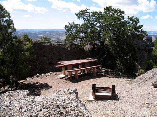
From Salt Lake City, head south on I-15 and take the exit for US 6 and Price near Spanish Fork Utah. It is about 60 miles to Price from the interstate. From Price, head south on highway 10 and drive to the exit for highway 155 as it heads to Cleveland. Go south through Cleveland and watch for the Cedar Mountain road, (signed) which is a graded good quality dirt/gravel road that you will follow all the way to the top of Cedar Mountain. It is a bit more than 40 miles to the top of Cedar Mountain from Price and 39 miles to an overlook that has a picnic area. (more about that in a moment). From Cleveland it is about 25 miles to that picnic overlook. Plan on about 2000 feet of elevation gain from Cleveland to the highpoint and do not take this road if there is snow present higher up (save the visit for another day). There are actually two overlooks on the way to the mountain's highpoint and both are worthy of a stop. The first overlook has informative signs which will help you to understand the area and the history a bit better. Along the Cedar Mountain road as it heads towards the mountain from Cleveland is a turn off for the Cleveland-Lloyd Dinosaur Quarry and a road that will take you to Buckhorn Wash and the Wedge Overlook. (Have a map) From I-70, go north to Huntington, passing through Ferron along the way. Take the highway 155 exit and go to Cleveland. Turn south in Cleveland and join up with the Cedar Mountain road. The highpoint is just off the road and is marked with a benchmark.(see pics) No register was found nor was one expected to be found under the proximity to man made structures that receive a fair amount of traffic.
 | 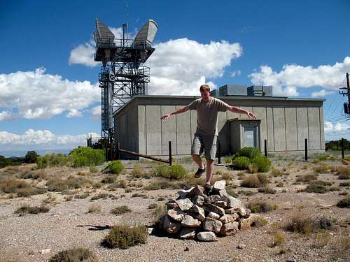 Highpointing fun
 | 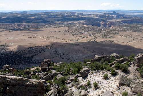 Looking to the south
 |
Red Tape
The land is administered by the BLM For more information: Address: Bureau of Land Management Price Field Office 125 South 600 West Price, UT 84501 Phone: (435) 636-3600 Consider stopping at the BLM office in Price for up to date road information, maps and advice on camping possibilities. ------------------------------------------------------- BLM WEB SITE FOR THE SWELL
Camping & the weather
Most of the public lands near the Cedar Mountain area are open to dispersed camping. The closest State campground is in Huntington, near State Highway 10, about 21 miles south of Price. Motel accommodations are available in Price, Huntington, and Castle Dale, on State Highway 10, 32 miles south of Price.

Camping opportunities in the nearby area are found under the Price field office section on this BLM link.

----------------------------------------------------------------------------


Views toward the south
 |  |  As seen from the first overlook
 |

Links
Mike Kelsey's book about the San Rafael Swell can be found here. Cleveland-Lloyd Dinosaur Quarry-A turnoff to this fascinating site is passed on the Cedar Mountain road and if you have the time, would make an interesting side trip.
 As seen from the first overlook