
-
 15107 Hits
-
 84.27% Score
-
 18 Votes
|
|
Mountain/Rock |
|---|---|
|
|
39.11610°N / 105.2736°W |
|
|
Teller |
|
|
Hiking, Scrambling |
|
|
Spring, Summer, Fall |
|
|
8939 ft / 2725 m |
|
|
Overview
 Huge summit cairn and cross on Cedar Mountain
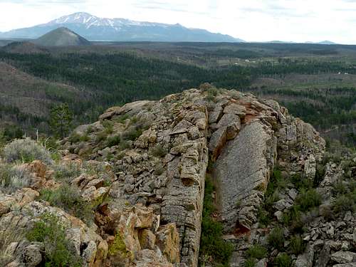
This is, in my mind, one of the coolest of the local, lower peaks in the Rampart Range area. From the summit, you can enjoy wide-open views of the surroundings, a rarity for a peak this low. Surrounding views include the Lost Creek Wilderness and the Park County 77 corridor, mighty but lonely Pikes Peak, several Hayman-scorched sentinels like Signal Butte and Pilot Peak, and much of the gently rolling Rampart Range.
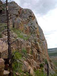
The summit area is exhilarating, rocky and wind-swept, featuring a huge rock cairn and large aspen wood cross. The apex is guarded by sheer cliffs jutting bravely out of their surroundings. Regardless of your route you are guaranteed at least a Class 3 scramble (though several moves in my route approached Class 4 and the wall with the ladder would be low 5th-class without the installed aids). The entire experience is much more “red rock canyon country” than “Rocky Mountain alpine.” Stunted, pygmy Ponderosa Pine cling to life in red gravel among granite outcrops.
Though scorched by the maligned Hayman Burn of 2002, the plant life on this peak is returning with vigor and includes purple penstemon and yucca. The wildflowers in spring take full advantage of the sunny slopes (open thanks to the burn) and bloom in a riot of colors. So close to Denver and Colorado Springs, grand views and surprisingly spicy scrambling, all requiring a relatively short hike – if not for the several miles of 4x4 roads between the 2-lane blacktops and this peak, I would imagine this fine gem would be overrun with visitors. For better or worse, though, few of the ATV riders visiting the area bother to dismount to visit Cedar Mountain, and the result is a scrappy little scrambly peak you can have to yourself.
Colorado Rank: 2964th highest peak
Prominence: 399 feet
YDS Rating: Class 3+
USGS Quad: Hackett Mountain
Trails Illustrated Map: #137 Pikes Peak Cañon City
Rank and prominence source: Lists of John
Getting There

Cedar Mountain is in the far northwestern corner of Teller County near the border with Park, Douglas and Jefferson Counties. Major access roads are US Hwy 24 to the south and CO 67 to the east. Teller County Road 51 turns into Forest Service Road 360, which is Cedar Mountain Road.
Note: Regardless of approach, you will need a 4x4 to reach this peak. A high-clearance V8 truck, van or SUV may do in dry conditions, but if the skies open up and the dirt roads turn to soup, your stay will be involuntarily extended. The roads approaching this peak go from relatively tame to steep, rutted and washed out and a 4x4 with descent clearance is the only sane option.
Red Tape
 NW from below the summit
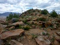 NNW toward the summit
There is very little red tape in this part of the Pike National Forest. Don’t burn anything down, don’t shoot anyone and keep your 4x4, ATV or dirt-bike on established motorized trails. This is a heavily used recreation area near major urban centers of the I-25 corridor. Do your part to tread lightly.
Camping & Lodging
 Cedar Mountain, western cliffs
 Pikes Peak and Signal Butte
 Summit cross, Cedar Mountain
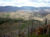 West from the summit
CAMPING
Rustic camping in “unofficial” campsites is available throughout the Cedar Mountain Road (FS 360) area, right off the main road and spur dirt roads off of it. These campsites are available on a first-come, first served basis and provide no services (they are entirely rustic). Most are dry campsites and will require water to be hauled in for cooking, cleaning and bathing.
Be forewarned that the proximity of this area to the urban I-25 corridor means that crowding can be an issue, especially in the summer. Be prepared for heavy ATV use, large crowds, drunkenness and plenty of target shooting.
The National Forest Service operates three general-use campgrounds in its Manitou Park Recreation Area. The Manitou Park Recreation Area is located about 5 miles north of Woodland Park along Hwy 67. Below is information about these campgrounds as provided by the Forest Service.
South Meadows Campground: Site has 64 camp sites with parking areas up to 30' long within the 8,000' elevation. Camping season is year round with a user fee of $15.00/per night/per site. The camp-ground has paved roads. Limited sites are reserved by calling 1-877-444-6777. Reservations may be made 240 days prior to arrival and there is a reservation fee. There is also a 2-night minimum stay if your reservation is for Friday or Saturday nights.
Colorado Campground: Site has 81 campsites with parking areas up to 30' long within the 7800' elevation. Camping season usually begins late May and runs until early September. The user fee is $15.00 per night/per site. This campground has paved roads. Limited site reservations can be made 240 days prior to arrival by calling 1-877-444-6777. There is a reservation fee. There is also a 2-night minimum stay if your reservations are for Friday or Saturday night.
Painted Rocks Campground: Area has 18 campsites with parking areas up to 30' long within the 7800' elevation. Camping season usually begins in May and runs through early September. A user fee of $13.00 per night/per site is charged. Limited sites are reserved by calling 1-877-444-6777 and can be made 240 days prior to arrival. There is a reservation fee.
HOTELS
A few simple hotels (many family-run) are available in Woodland Park (elevation 8,465 feet) along with several RV sites and cabins.
For more information visit The Greater Woodland Park Chamber of Commerce Visitor Information page.
Weather & Seasons
 West-facing wall
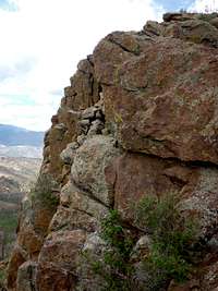 Dramatic west-facing outcrops
Cedar Mountain could be enjoyed year round, though accessibility would be an issue in the winter without a snow machine assist. Springtime will be muddy and sloppy and road closures or blockage by snow drifts may affect the total hiking distance. Summer can be hot and dusty and this area is extremely crowded with ATV traffic. Fall would be a cooler, more pleasant and less crowded time to pay Cedar Mountain a visit.
 Southeast toward Pikes Peak