
-
 12874 Hits
-
 81.18% Score
-
 13 Votes
|
|
Mountain/Rock |
|---|---|
|
|
38.77240°N / 104.9933°W |
|
|
Teller |
|
|
Hiking |
|
|
Spring, Summer, Fall, Winter |
|
|
12349 ft / 3764 m |
|
|
Overview
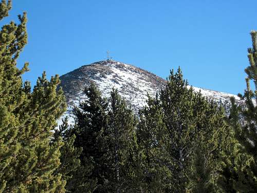 Approaching from the west-southwest
UN 12,349, unofficially known as “Almagre Mountain South,” is one of just a small handful of peaks emerging above timber line along the horizon immediately west of Colorado Springs. This alone makes this peak special, despite the summit structure and repeater tower marring the top.
On most maps, the name Almagre Mountain is applied to a rather large, multi-humped mountainous area rising in excess of 12,000 feet that includes Almagre Mountain (the northern summit which rises to 12,367 ft.) and Baldy (12,226). In fact, stand in Colorado Springs and point up toward the Almagre vicinity, then ask 100 people “What’s the name of that mountain?” and expect to receive a few dozen different answers, with many of them being a variation of “I don’t have any idea.”
Regardless of this identity crisis, this ranked peak provides outstanding views of the Sangre de Cristos and even the Sawatch. The in-your-face views of Pikes Peak are delightful, too.
Colorado Rank*: 1105th highest peak in Colorado
Prominence*: 369 feet
USGS Quad: Manitou Springs
Trails Illustrated Map: #137 (Pikes Peak, Cañon City)
*Rank and Prominence Reference: Lists of John
Getting There
“Almagre Mountain South” sits in far southwestern Teller County, not far from the border with El Paso County. To the south,Almagre Mountain South” is flanked by Beaver Creek (west) and East Beaver Creek (east); these drainages provide access to the peak. Following Old Stage to Gold Camp out of Colorado Springs behind the Broodmor, one can access routes up this peak either via FS 379 toward Frosty Park or FS 376 toward the Utilities 4-way.

Note that the western approach (FS 376) is graded for 2-wheel drive vehicles and plowed throughout the winter (for the most part). FS 379 (eastern approach) is a much more rugged route. Many will not take their stock 4x4s upstream of the first major stream crossing. It is not uncommon to see stranded (stuck) and / or disabled vehicles further up the road near / in Frosty Park.
Red Tape
 From across the basin
 Lovely Mount Rosa
There is private property (utilities) on the western slope of “Almagre Mountain South.” Be mindful of where you are in relation to property lines.
There are no fees or permits required to access this part of the Pike National Forest. There really are few regulations governing usage of this area. In fact, some sectors of this area can feel downright lawless Wild West at times.
- Do not litter and dispose properly of human waste.
- Shoot only in designated target ranges and point your firearm away from other recreationalists.
Camping & Lodging
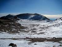
 Stratton Reservoir basin
 Pikes Peak and Almagre Mountain
Rustic car camping and backcountry camping can be throughout the surrounding Pike National Forest. Be forewarned that the proximity of this area to the urban I-25 corridor means that crowding can be an issue, especially in the summer, and that unsavory characters are known to frequent this area. Be prepared for heavy ATV use, large crowds, drunkenness and casual firearms usage without a mind toward NRA-recommended safety precautions.
FS 376: Due to private property holdings in the area as well as relatively high travel (recreation and utilities use), camping in the western approach (Beaver Creek) drainage is limited.
FS 379: There are places to camp up in/near Frosty Park. Let it be written that this is a popular area for folks to unwisely combine drinking with target shooting. Personally, I would not bother camping in this vicinity.
While the Old Stage area provides for all of the rustic camping you could hope for, I honestly suggest not spending the night in the area for the sake of peace and quiet, and even for your safety. Old Stage Road serves as a conduit for the urban masses to explore Pike National Forest. While this sounds like a good idea, the reality is messy (garbage, spent shells, beer bottles, auto parts and busted clay pigeons) and sometimes grim. In October 2008 the body of 19 year old, mentally disabled Judi Lawrence was discovered near Old Stage Road; she had been raped and murdered.
Do yourself a favor and stay in town, visiting “Almagre Mountain South” as a day excursion.
Hotels, Cabins & B&Bs
 Sunset on west ridge
 Southwest from west ridge
Old Colorado City
Nearby Old Colorado City has an assortment of lodging options, old and new, for all budgets. Restaurants, bakeries and shops are within strolling distance from many lodging facilities.
Manitou Springs
Manitou Springs lies at the foot of Ute Pass. This colorful, eclectic town offers a wide range of lodging options including old-style motor cottages and cabins, retro family-run motels, charming B&Bs and modern chain hotels. Shopping and dining are within walking distance of most Manitou lodging. Visit the a Manitou Springs Visitors Website for more information on lodging in the area.
Colorado Springs
The hotel options in Colorado Springs are virtually limitless. If you are the 5-star luxury type, be sure to check out The Broadmoor, which is extremely convenient to the eastern terminus of Old Stage Road.
Weather & Seasons
 West toward repeater towers
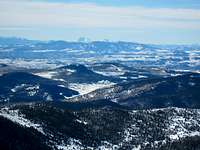 Mount Ouray 13971 ft.
“Almagre Mountain South” is certainly doable in the winter months. Keep a sharp eye on snow conditions and choose your route carefully. The steep, west-facing slopes tend to be cross-loaded with pillows of snow and could be prone to sliding. Summer months bring heavy Jeep & ATV traffic to the dirt roads surrounding “Almagre Mountain South” on three sides, and Old Stage Road is crawling with teens blaring obnoxious music, drunks shooting into thin air (no, I’m not making this up) and tourists nervous about damaging their rental car on the potholes and ruts. Spring access to the summit would depend on the year’s snowpack; a heavy snowpack would mean deep drifts of soft, late-season snow lodged in the trees and, as with winter, spooky cross-loading on the western slope. Fall is a nice, though likely cold and windy, time to be on this mountain.
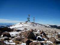
 Repeater tower on summit