
|
|
Mountain/Rock |
|---|---|
|
|
38.76610°N / 104.9205°W |
|
|
9782 ft / 2982 m |
|
|
Overview
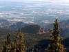
Stove Mountain, also know as Cookstove Mountain, is a prominent peak in El Paso County, Colorado. It looks down upon the likes of Muscoco Mountain, Mount Kineo and Mt. Cutler, but is easy to miss because it lies in the shadow of the taller and very beautiful Mt. Rosa. It is a difficult peak to reach, but is very much worth the effort, as it’s summit packs some spectacular views of the surrounding mountains and Colorado Springs. The final 250 vertical feet involve some easy Class 3 scrambling; otherwise it is Class 1 hiking. The last mile is all route finding and I strongly recommend only attempting this mountain with a good topo map, compass and/or GPS. This can be a short 2-mile climb or a 10-mile hike depending on which route you take and if you enjoy 4-wheeling on a rough road. See the route section to make your choice. Whichever route you take, the summit makes it all worth your while. Like many Colorado mountains, it seems that it’s history involves a lot of mining. I was not able to find that much information on the Web about this peak, other than it is the site of multiple abandoned mines. Geology hobbyist sites listed the types of rock found in the area, including zircon, fluorite, riebeckite and the very cool sounding astrophyllite. So, if you are looking for a great climb in the Colorado Springs area or you have a peckish to find some astrophyllite, climb Stove Mountain!
 |  |  |
Getting There
I strongly recommend using the Pikes Peak Atlas for this route. This can be found at the Colorado Springs REI and many local bookstores. I think it is much better than the National Geo. Topo map.
Forrest Road 381 Route: Take I-25 from either the north or south to Exit 140. Go south on Rt. 115, which is Nevada Ave. Get off at the westbound Lake Ave exit. Take your second left onto Cheyenne Mt. Rd. and follow this until you come to the sign for the Cheyenne Mt. Zoo, which will be to the left. Go straight through this intersection and take Old Stage Road into the mountains. I strongly recommend using the Pikes Peak Atlas Map from this point. Follow Old Stage Rd. until it merges with Gold Camp Rd. Continue on Gold Camp to Forrest Rd 381, which will be on the right. Only brave this road with a good 4W drive vehicle with good clearance. Overall, it is not that bad, except for a small handful of very rocky sections that make it a potentially treacherous drive. Follow FR 381 2.1 miles until it ends at a gathering of smaller trails that mark the site of an abandoned mine. At this point you are at ~ 10,100 ft. and actually above the 9782 ft. summit, which is about a mile away.
St. Mary’s Falls Route: Take I-25 from the north or south to Exit 141 and take Take US Highway 24, also known as Cimarron Street or the Midland Expressway, to 21st St. Go south on 21st St., which changes into Cresta Rd. Follow Cresta to Cheyenne Blvd. and take a right. When you come to a fork in the road, take the right fork, which is North Cheyenne Canyon Road. The left fork goes to Seven Falls and the Starsmore Discovery Center is between the two. Take Cheyenne Canyon Rd. past the Mt. Cutler trailhead and Helen Hunt Falls until it ends at the Gold Camp Rd. parking lot where you will need to park. Gold Camp Rd. is on the left side of the parking lot. This part of the road is closed to vehicles, but open to hikers and bikers. This is where the St. Mary’s Falls route begins.
Red Tape
No permits or fees are required. The beginning of Gold Camp Rd. for the St. Mary’s Falls route is closed to vehicles due to the collapse of two tunnels on it’s route, but only adds a mile to the hike each way.
When To Climb
Any time of the year. Beware of afternoon Colorado thunderstorms in the summer. Be prepared for deep snow in the winter and spring. Snowshoes are advised, especially for the St. Mary’s Falls route at these times.
Camping
There are many places to camp along either route, many with excellent views.
Mountain Conditions
See the links page for Colorado Springs weather. Most importantly, “watch your back.” Much of the weather moving in from the west and the north is obscured by Mt. Rosa and surrounding peaks and can be on top of you quickly. The final mile along the undulating summit ridge is exposed and would not be good place to be caught in hostile weather.
External Links
- my favorite link
Local weather for the Colorado Springs area.