
|
|
Mountain/Rock |
|---|---|
|
|
46.46476°N / 11.64362°E |
|
|
Hiking |
|
|
Summer, Fall |
|
|
9478 ft / 2889 m |
|
|
Overview
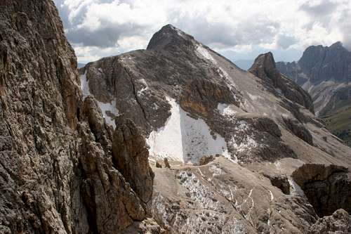 Cima Scalierét and its north ridge (by Piku)
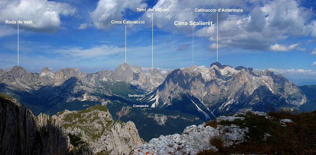
Cima Scalierèt is an important summit placed in the center of Catinaccio/Rosengarten group.
It belongs to Larsèc subgroup and, with its height of 2889m, it's the highest summit of Larsèc and one of the highest of the whole Catinaccio group.
Despite of its considerable height, due to its massive shape, it isn't much noticeable, mainly if observed from distance... But it remains one of the most important and panoramic summits of Catinaccio range and surely it deserves a visit.
This mountain has roughly a pyramidal shape: it hasn't big faces of rock but its steep slopes are mostly covered by scree and loose rocks: in fact, "Scalierét" arises from ladin "Scalieréc" meaning "plates covered in scree" (cf. A. Bernard, La nuova guida del Catinaccio, 2008). A beautiful ridge joins this peak with Antermoja pass toward north, while on the other sides it falls with slopes covered of gravel over Pope pass on south-west, Vajolet valley on west and Larsèc valley on east.
Because of its lack of rocky wall, Cima Scalierèt doesn't offer any opportunities for climbers and alpinists, but its height and its position (isolated and central) make this peak a wonderful aim for hikers who loves panoramic views and not crowded trails.
Getting There
The best starting point to reach Cima Scalierèt is Gardeccia Hut.You can easily reach Gardeccia Hut from Pera di Fassa, with a taxi service starting from the parking of the chair lift "Vajolet". Click to download the timetables (PDF format)
As alternative, from Pera di Fassa you can take the 3 chair lifts leading to Ciampedìe (Vajolet1, Vajolet2, Ciampedìe) and, from there, in about 45' (trail 540) to Gardeccia Hut.
Ciampedìe is also reacheable with a cablecar from Vigo di Fassa.
You can reach Vigo and Pera di Fassa by car:
- From North: taking A22 motorway until "Bolzano Nord" exit. From there, follow the route SS241 "Grande Strada delle Dolomiti" via Passo Costalunga - Val di Fassa (distance 37km to Vigo, 40Km to Pera)
- From South: taking A22 motorway until "Ora/Egna" exit. From there, follow the route SS48 delle Dolomiti via Passo San Lugano - Val di Fiemme - Val di Fassa (distance 52km to Vigo, 55Km to Pera).
You can reach Vigo and Pera di Fassa by bus:
- From Bolzano/Bozen: click here to see timetable of bus service SAD
- From Ora/Auer: click here to see timetable of bus service SAD
- From Trento: click here to see timetable of bus service Trentino Trasporti
Closest railway stations: Bolzano/Bozen, Ora/Auer, Trento. See the Ferrovie dello Stato website for informations and timetables.
Red Tape
In all the area free camping is not allowed.No fees and permits required.
  |
Routes Overview
 Click to enlarge the map
- From Passo Scalierét and the north ridge, Diff: EE
from Gardeccia hut (1949m) take trail nr. 546 to Vajolet and Preuss Huts (2243m, 45min); from Vajolet Hut, take trail nr. 584 to Passo Principe Hut (2600m, 1h, 1h45min from Gardeccia); from Passo Principe, take trail nr. 584 to Antermoia Pass (2769m, 20min, 2h from Gardeccia); from Antermoia pass, take the trail (no number) crossing the scree descending from Cima Larséc, reaching Scalierét pass (2790m, 15min, 2h15min from Gardeccia); from there, follow the trail running on the Cima Scalierét north ridge, to the summit (2889m, 30min, 2h45min from Gardeccia)
- From Passo delle Pope (Pope pass) and the south-west flank, Diff: EE
from Gardeccia hut (1949m) take the trail nr. 546 to Vajolet and Preuss Huts (2243m, 45min);
from Vajolet hut take the trail (no number) crossing the Soàl creek and rising up to the Pope pass (2617m, 1h30min, 2h15min from Gardeccia); from Pope pass follow (east) the marked trail (no number, paint signs and cairns) leading to Cima Scalierét (2889m, 45min, 3h from Gardeccia)
passo delle Pope is also reachable via Scalette pass and the Larséc bowl: from Gardeccia take trail nr. 583 (Sentiero Larséc/Larsécweg) to Scalette pass (2400m, secured path, 1h30min); from Scalette pass take toward west a weak trail crossing the wild Larséc bowl and leading below Forcella delle Pope, then to Passo delle Pope (2617m, 1h, 2h30min from Gardeccia)
When to Climb
Best seasons are summer and autumn, from late June to October.In early season (June and July) and in autumn (late September and October) crampons and ice-axe are often necessary
To identify Cima Scalierét
Some views of Cima Scalierét from various sides  From Scalierét pass (N) From Scalierét pass (N) |
 From Cigolade pass (S) From Cigolade pass (S) |
|---|---|
 From Pope pass (W) From Pope pass (W) |
 From Valle di Lausa (E) From Valle di Lausa (E) |
 From Scalette pass (SE)
|
Guides, Maps, Meteo links
 Scalette pass, the Larséc's Gate! (by Vid)
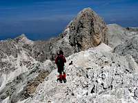 On the north ridge
Guides
- Andrea Gabrieli, Gruppo del Catinaccio, Luca Visentini Editore, 2010
- Antonio Bernard, La nuova guida del Catinaccio, Edizioni Mediterranee, 2008
- Luca Visentini, Gruppo del Catinaccio, Athesia, 1982, also in german language with the title "Rosengarten" (out of catalogue)
- Arturo Tanesini, Guida ai Monti d'Italia: Sassolungo, Catinaccio, Latemar, CAI-TCI 1953 (out of catalogue)
Maps
- Tabacco, foglio 06, Val di Fassa e Dolomiti fassane, 1:25.000 (the best)
- Kompass, Rosengarten/Catinaccio Latemar, 1:25.000
- LagirAlpina, Carta Escursionistica-Mountainbike Val di Fassa, 1:25.000
Weather forecast