
|
|
Mountain/Rock |
|---|---|
|
|
39.47740°N / 119.8635°W |
|
|
Washoe |
|
|
Hiking |
|
|
Spring, Fall, Winter |
|
|
5483 ft / 1671 m |
|
|
Overview
Sitting on the eastern edge of the Mount Rose Wilderness, Cross Peak rises just over the hillside neighborhoods of western Reno. If looking towards the Mount Rose Wilderness from Reno, Cross Peak fails to stand out. However, once you get close to it, it makes an instant impression. That is because of its steep rise and its rocky summit. Cross Peak rises like a thumb, sticking 400 feet up from its surrounding terrain. This sets it apart from the larger and more gradually sloping hills surrounding it.
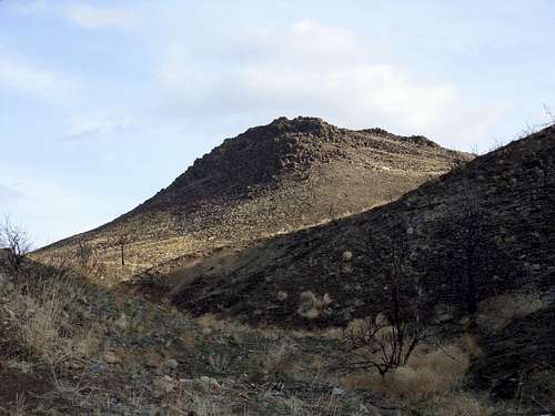 On the way to Cross Peak.
Cross Peak didn't use to be so close to the community. Urban development encroached further up the hills until it finally ceased before it crossed over the peak.
Because of its accessibility, Cross Peak is an excellent after work hike. It takes about 20 minutes to reach the summit; even less if you run to the base. The last quarter mile is very steep, and works the calf muscles and lungs. Views from the summit are quite expansive, with the whole city of Reno in view.
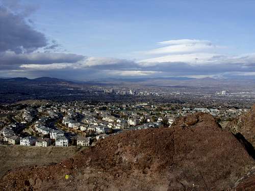 View of Reno from the summit
Getting There
There are a couple primary options. Either Pine Bluff Trail or the Steamboat Ditch Trail.
Pine Bluff Trail is off Village Green in Caughlin Ranch. Just put Pine Bluff Trail Reno NV in maps and you'll get there. Once at the parking area, there are two options. The first option is to head down a road and then very quickly take a left on a trail heading down into the forest.
Pass under Cross Peak and then turn right on a trail leading up to the peak. It is 3/4 miles of hiking one way, gaining a little over 300' net. On the way back, you'll have to gain 150' back to the car. To make it longer, head down the whole road, and take a left. It is about 1 mile of one-way hiking this way, gaining about 400'. There are additional hiking options as well using this starting point, but these are the shortest.
The second starting point is at Bitteroot Road. From the McCarran Blvd west loop to the south entrance of Caughlin Parkway at the crest of the hill. Take a left on Caughlin Parkway and follow north as it winds around the hills. After about 1½ miles find Sawbuck on the right. Take a right on Sawbuck downhill and turn left on Bitteroot. About 100 yards down Bitteroot on the right is the entrance to the Steamboat Ditch Trail. This is where you start the hike.
If heading from I-80 go south on McCarran Blvd west loop to the north entrance of Caughlin Parkway. Follow the road as it winds southward. After about 1 1/4 miles you will find Bitteroot on the left. Follow it for less than 1/2 mile where you will see the trail.
Start on the Steamboat Ditch and take a right and go under a tunnel. Eventually it becomes a paved trail and then a dirt trail. After 3/4 miles there is a road on the right. Take this road and then it will turn left towards the mountain. It is about 1.2 miles to the summit gaining 600'. You can also continue on the trail and go to the backside as described for the other route. This is about 1.5 miles with a similar gain and can be done as a loop to be 2.7 miles.
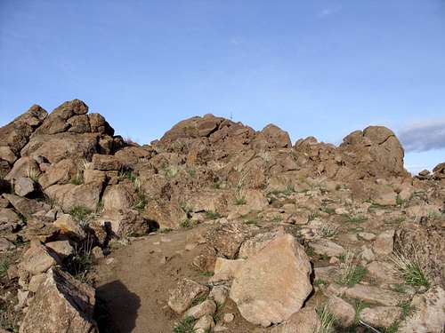 Looking back to the rocky summit of Cross Peak. Notice the cross - which marks the true summit.
Red Tape
There is a "No Trespassing" sign on the fence in front of the dirt road leading to the peak. Take the paved trail instead to avoid this. That is the public trail.