-
 21528 Hits
-
 83.69% Score
-
 17 Votes
|
|
Mountain/Rock |
|---|---|
|
|
33.38736°N / 116.95549°W |
|
|
San Diego |
|
|
Hiking, Mountaineering, Mixed, Scrambling |
|
|
Spring, Fall, Winter |
|
|
5077 ft / 1547 m |
|
|
Overview
Located in the Agua Tibia Wilderness within the Cleveland National Forest, Eagle Crag is a 5,077 ft peak located in the northwest part of the Palomar Mountain Range. East of Temecula and south of SR 79, Eagle Crag is perched 1/4 mile south of the Palomar Magee/Cutca Trail, 2 miles east of the Crosley Saddle and can be reached from either the north and west by the Agua Tibia Wilderness trails or the south and east from Aguanga or Palomar Mountain State Park.
With over 25 miles of hiking trails, the Agua Tibia was established as a wilderness on January 3, 1975. This 15,933-acre area is mountainous and cut by many deep canyons containing only intermittent streams. Vegetation is mostly chaparral with oak woodlands and some coniferous forests at the higher elevations. Small pools of water in the canyon bottoms become warm in summer months and thus the name Agua Tibia. Summer temperatures may exceed 100 degrees in the canyons and on the slopes, but are a moderate 80-90 degrees at upper elevations. Rain averages 25 inches annually and falls usually from January through April. Snow occasionally falls on upper slopes.
Getting There
There are several routes to summit Eagle Crag, and while none are considered easy the mileage differences in them can make some routes less strenuous and thus a better hike. The first route is via the Cutca Valley Trail.Distance: 18 miles round trip on trail, road, and cross-country
Gain: 4200' total, 2700' out plus 1500' on return
Time: 9-10 hours round trip
Rating: Class 1, strenuous
Getting to Cutca Valley Trail
Take I-15 south to Temecula.
Take the South SR 79 exit.
Continue south on SR 79 to Aguanga (junction with SR 371), 18.2 miles east of Temecula.
Continue southeast on SR 79 for 0.4 mile to Palomar Divide Truck Trail on the right. There is now a sign that says Rancho California RV Resort. The road is labeled 8S05. Turn right on to this road.
At 0.4 mile, fork with a dirt road (Palomar Divide Truck Trail). Go left.
At 3.1 miles, seasonal gate.
At 5.4 miles, saddle with parking space for several cars and the (signed) Cutca Valley trailhead. Park here.
Cutca Valley Trail to Eagle Crag
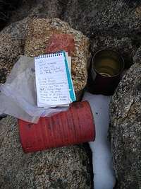
From the parking area (3794'), hike about 0.6 mile down the Cutca Valley Trail (1E01) into Cottonwood Canyon. Cross a stream. About a mile from the trailhead, the trail reaches a small saddle and becomes a road. The road continues across Section 16 and into the southern part of Section 17, staying between 3400' and 3600'. It joins the Cutca Truck Trail at the boundary of Section 17 at a sign "Cutca Truck Trail" and "2.3 Section 16". (This is about 2 hours at a moderate pace from the parking area). Turn right (north) on the road, cross a stream after about 50 meters, then continue about a mile, where there is a sign "Trail" on the left. The trail is shown on the topo. Turn left and follow this trail up a canyon and into the Aqua Tibia Wilderness, past a saddle at 4200', and to a junction with the Palomar Divide Truck Trail (2W01) at 4720'. Turn right (west) and follow the road about 100 meters to an obvious gully on the left. The gully is marked by a duck; if not, please place one. Leave the road here and go up the gully staying in trees to the left as much as possible to avoid brush. Continue up to where the gully divides, and take the right (west) fork or the center ridge staying above and close to the right fork, finding the most open path possible, to the top of the ridge where a long clearing (old firebreak) through manzanita leads to a saddle, then work your way through thick manzanita to the summit. The register can is located on the rocks just south of the highest point.
Note: Eagle Crag is not the highest point on the ridge.
SPECIAL CONDITIONS
The gate at 3.1 miles from SR 79 is a "red gate", meaning that it is open except for major problems such as a washout. For information about this gate, contact the Forest Service Station at Oak Grove at: (951) 767-9144.
Driving this road is not advisable when wet, due to the adobe surface, which turns to a slippery quagmire, together with the slope of the roadbed toward the canyon.
The second route is from the Dripping Springs Trailhead via the Wild Horse Trail.
Distance: 24 miles round trip on trail, road, and cross-country
Gain: 4500'
Time: 11-12 hours round trip
Rating: Class 1, very strenuous
Getting to the Dripping Springs Trailhead
Take I-15 south to Temecula
Go east on SR 79 for about 10 miles, cross a narrow bridge and turn right to Dripping Springs Campground. Park in the lot on the right near the entrance.
Dripping Springs to Eagle Crag via Wild Horse Trail
Walk the road to the southeast end of the campground where a sign and trail register are located. Sign the register, then proceed across a seasonal stream (flooded after heavy rains). Just past the "Agua Tibia Wilderness" sign, the trail reaches a trail junction with the Wild Horse Trail on the left and the Dripping Springs Trail on the right. Turn left and go 7 long miles as the trail contours 200' above Arroyo Seco then ascends the east shoulder of Wild Horse Peak passing through the saddle west of Agua BM, and then descends to a former dirt road. Turn left and descend about 1/4 mile to a switchback on the right, which leads to a seasonal stream. Cross the stream and a very distinct cow trail and ascend the south side to a road at 2800'. Cross the road (private property in both directions) and pass through a gate. Continue 3 miles on the former Crosley Truck Trail (now a trail) to Crosley Saddle (3931') and a signed junction with the former Palomar-Magee Truck Trail (now a trail). The right fork leads to Agua Tibia Mountain and the Dripping Springs Trail.
Turn left and go 1.5 miles (1/4 mile past the saddle at 4468') to a small gully marked by a duck. Continue up the gully and follow the same directions as in Route 1.
Another route originating from the Dripping Springs trailhead, in which one could also climb Agua Tibia Mountain and then on to Eagle Crag, would be to follow the Dripping Springs trailhead to Eagle Crag via the Dripping Springs/Palomar-Magee trail.
Distance: 23 miles round trip on trail, road, and cross-country
Gain: 5100' total, 4300' out plus 800' on return
Time: 11-12 hours round trip
Rating: Class 2, very strenuous
Getting to the Dripping Springs trailhead
Same as the route above.
Dripping Springs/Palomar-Magee Trail to Eagle Crag
Same directions as above until one comes to the trail junction with the Wild Horse Trail on the left and the Dripping Springs Trail on the right. Turn right onto Dripping Springs Trail (1W03) and follow it for 7 miles to where it joins the Palomar-Magee Truck Trail at a signed saddle just west of Agua Tibia Mountain (near the "T" in "Tibia" on the Vail Lake topo). Turn left and follow it 2 1/2 miles as it contours on the northwest shoulder of Agua Tibia Mountain, where one can choose to bag the peak, and descends to Crosley Saddle at the junction with Wild Horse, Palomar-Magee and the Cutca Trail. From here continue on following the same directions as above.
Another route from Palomar State Park over Morgan Hill passes through private property (Weber Ranch) and the Mission Indian Reservation. Neither the rancher nor the Indians give permission to hike through their land. Unauthorized use of this route jeopardizes the efforts of trail crews to gain access along it.
Red Tape
The best time to hike is early fall through mid-spring.Drink and bring plenty of water.
A Wilderness permit is needed for overnight use and the Adventure Pass is needed when parking at any TH located in the Cleveland NF.
For more info on Cleveland National Forest Passes and Permits click Here
Camping
Camping is permitted at both the campgrounds(tempororarily unavailable) and in the Cleveland National Forest. Permits and fees are required. For more information on the Dripping Springs Campground clickHERE
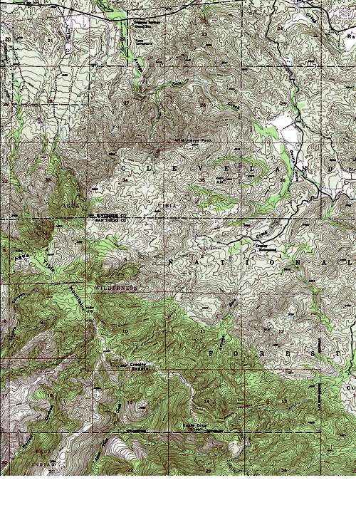
External Links and Topo
Much of the info found above and much more can be found at the following sites:TCHESTER'S AGUA TIBIA WILDERNESS PAGE
Bob Burd's EAGLE CRAG Trip Report
CNF's Dripping Springs Trail Page
Sierra Club's Eagle Crag Page
My Photos of Eagle Crag


