
-
 8379 Hits
-
 79.24% Score
-
 11 Votes
|
|
Mountain/Rock |
|---|---|
|
|
46.89668°N / 13.42049°E |
|
|
Hiking, Skiing |
|
|
Spring, Summer, Fall, Winter |
|
|
8504 ft / 2592 m |
|
|
Overview
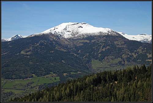
Gmeineck from the east

Stoder from Gmeineck
Those, whose hearts are beating for tour skiing, will feel a high temptation, looking on Gmeineck in spring. When you are driving by the highway from Villach towards Spittal, its regular slopes are inviting you to visit it with skis - they are promising 1500 altitude meters of pure joy. Of course it can be also a pleasure to hike on it in summer or in autumn. The ascent is easy and panoramic. The lower parts of Gmeineck are also very attractive for mountain bikers, which find there some nice tours.
Gmeineck is standing on the very South-East in Reisseck group, so being one of the 'last' (or 'first') summits of Hohe Tauern. It stands in the corner among rivers: Moell, Drau and Lieser. From the Lieser side it is in the first row, while from the Moell and Drau side one lower mountain ridge is stretching in front of it, and between both streaks the long Hintereggengraben lies. All these mountains are gaining altitude towards the North-West. Both mountain ranges join at the end of Hintereggengraben on Rossalmscharte (notch), above which the highest summit of this small group stands: Hohe Leier.
The southern and western slopes of Gmeineck are grassy and not very steep, towards the north and east the mountain lowers with more rocks and even short walls. The nearby eastern fore-summit is called Stoder, 2433 m, and is also a valuable goal for tour skiing.
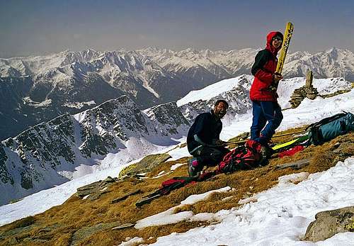
We rarely say for a mountain that the panorama from its summit is a usual one. The panorama from Gmeineck is certainly nothing so special. Still, quite a part of the Reisseck and Hafner group can be seen from its summit, towards the South, Carnic Alps can be seen, further towards the South-East Julian Alps and Karavanke / Karawanke and, interestingly, picturesque are even the modest Nockberge, lying towards the East. They are usually photographed in a contrast with the impressive north face of Stoder. Gmeineck itself is most picturesque, when observed from Milstaetter See.
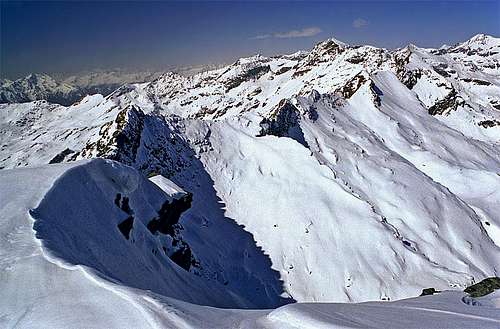
Towards the W |
Towards the SW |
Getting There
For a broader view see group pages: Hohe Tauern and Ankogel Group.
From the North, South and East, Gmeineck foothills can be accessed by highways. The bypassing highway is Villach - Salzburg, we exit it near Spittal, continuing by local roads. From the West, Gmeineck can be reached by the roads through Moell and Drau valley.
For the ascent you can use as a trailhead any of villages, lying East and Southeast of Gmeineck. The three most obvious are Trebesing, Altersberg and Hintereggen. The alternative, perhaps even more often approach goes from the south. From Lendorf we can drive up to Huehnersberg, from where we continue on foot or skis by a cart-road into Hintereggengraben. Eventual northern approaches (from Radlbach) are unknown to me, but in summer they shouldn't be impossible.
Routes Overview
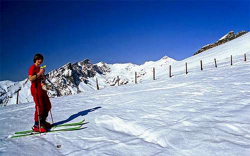
From the villages on the East many cart-roads and paths, marked and unmarked ascend over the slopes of Gmeineck. They join more or less all by the Bergfriedhuette (mountain hut), 1785 m, from where they continue on the summit of Stoder and Gmeineck. In summer you need for the ascent some 5 hours, in winter the same, if conditions are good. From Hintereggengraben cart roads ascend on the upper alpine meadows, from which mountain paths go further up to the top. These ascents require good 3 hours, but another 1 hour is needed to reach Hintereggengraben. Ski tours can be done along the approach paths. They are of medium difficulty and in addition to the one shown on the map left, there are also others towards the SE. You can see a detailed map (1:50.000) on-line on: http://www.austrianmap.at/, but the online map on the left is equally useful. Explore it in details! |
Red Tape
No limitations.
Huts And Camping
For the ascent only, huts and camping are not needed. The tour can be done in one day. Besides other private huts there are the following two mountain huts on Gmeineck slopes:
Below the Eastern shoulder of Stoder there is Bergfriedhuette, 1775 m. It is opened from mid June till mid September, has 6+20 beds, contact: Maria Färber, tel.: +43/664/5246781.
In Hintereggengraben there is Kohlmaierhuette, 1512 m. Tel.: +43 676 729 70 03.
When To Climb?
Gmeineck can be climbed any time of the season. The best time is the time for tour skiing and when the mountain is snow-free, the blossom time in early summer and the golden autumn.
Books
- Leo Baumgartner: Schitouren. Verlag Carinthia, 1994. (In German)
- Manfred Korbaj: Kaerntner Schitourenfuehrer, Band 1. H. Weishaupt Verlag, Graz. 1990. (In German)