
-
 3716 Hits
-
 81.18% Score
-
 13 Votes
|
|
Mountain/Rock |
|---|---|
|
|
47.34574°N / 12.02316°E |
|
|
Hiking, Mountaineering, Scrambling, Skiing |
|
|
Spring, Summer, Fall, Winter |
|
|
7270 ft / 2216 m |
|
|
Overview
 Gressenstein
The Alpbach - Wildschönau range, a long, south - north running ridge between Alpbachtal valley to the west and Wildschönau valley to the east, within Kitzbüheler Alpen, has many nice, easy summits worth a hike or a ski tour or a traverse (the latter can be easily expanded to an epic ...).
Gressenstein, located between Großer Beil in the north and Sonnenjoch to the south, is a minor summit of this range but nevertheless an interesting one. More than Großer Beil or Sonnenjoch, Gressenstein is a sort of “home summit” for beautiful Gressensteinalm, an old, picturesque wooden Alm hut east of the summit. Maybe this is because Gressenstein summit is visible from Gressensteinalm - which is therefore named after that mountain - and seems to be higher than the surrounding peaks.
When viewed from the ridge crest or from the adjacent summits it is quite clear that Gressenstein is “only” a minor summit, about 100 meters lower than Großer Beil. So what!
Do the traverse from Sonnenjoch to Großer Beil (or vice versa): Gressenstein is included.
Ascend Großer Beil with skies, ski down into Gressenstein cirque and ascend Gressenstein as an encore.
Double summit and double downhill fun.
 Gressenstein Gressenstein |  Gressenstein Gressenstein |  Gressenstein Gressenstein |
Getting There
 Gressenstein
Main trailheads for Gressenstein are:
The general accesses are described on the Kitzbüheler Alpen main page.
Routes Overview
Trails
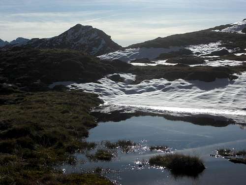
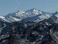 Summit view to Großvenediger Summit view to Großvenediger |  Upper Wildschönau valley Upper Wildschönau valley | 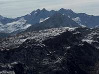 Summit view to Reichenspitz range Summit view to Reichenspitz range |
Traverse
 Gressenstein cascade Gressenstein cascade |  Gressenstein / Wildschönau trail Gressenstein / Wildschönau trail |  Gressensteinalm and Northern Limestone Alps Gressensteinalm and Northern Limestone Alps |
Ski route
Gressenstein has no direct ski route from and to Alpbachtal. If you want to ski up to Gressenstein from Inneralpbach do it via Großer Beil or Sonnenjoch – including a short downhill on the east side of the ridge. These ski ascents are steeper and more difficult as the Wildschönau route.
Red Tape & Accommodation
 Gressenstein and Sonnenjoch
Red Tape
There are no restrictions or regulations, as far as I know.
Accommodation
Wildschönau
Alpbachtal
Kelchsau
Hopfgarten
Kaltenbach / Stumm
Schönangeralm at the end of Wildschönau valley is a mountain inn with a genuine cheese dairy in summer - don´t miss that!
Gressensteinalm provides some drinks and food during the Alm season.
Otto - Leixl - Hütte is a private hut, accessible only for members of the possessing alpine club section.
Gear & Mountain Condition
 "Minor" Gressenstein below Großer Beil
As nearly all the surrounding peaks, Gressenstein can be summited the whole year.
In the hiking season you need full hiking gear and good shoes. The main summit route is an easy hike on a marked and / or cairned mountain trail and - near the valley - on forest roads.
The traverse Sonnenjoch - Großer Beil does need some easy rock scramble and, with low visibility - a knack for orientation.
The Wildschönau ski route is an easy one. The Alpbachtal ski ascent is steep and more difficult. Both routes are a treat for the advanced ski mountaineer.
Full ski and avalanche gear is required.
Check the Tirol avalanche bulletin here.
Current Weather:
Maps & Guide Books
 Gressenstein west face
For a wide list of Kitzbüheler maps and guide books see the Kitzbüheler Alpen main page.
Maps
Alpenvereinskarte 1 : 50.000; Kitzbüheler Alpen West, Nr. 34/1, Deutscher Alpenverein, 2010; - topo map with trails; the same with ski routes.
Österreichische Karte 1 : 50.000 - UTM (ÖK50), map number 3213, Wörgl
Guide Books
Available only antiquarian but an indispensable mountain guide book:
Georg Bleier, Kurt Kettner: Alpenvereinsführer Kitzbüheler Alpen, Bergverlag Rudolf Rother, München, 1984
Horst Höfler, Kurt Kettner: Kitzbüheler Alpen. Mit Skirouten. Führer für Täler, Hütten und Berge, Bergverlag Rudolf Rother, München, 1976
R. Weiss: Skitouren Kitzbüheler Alpen mit angrenzendem Salzburger Anteil am Nationalpark Hohe Tauern, Gebietsführer, Steiger Verlag Innsbruck, 2000 (there is an antiquarian edition from 1985 with only Kitzbüheler Alpen, too)