
-
 13364 Hits
-
 87.31% Score
-
 24 Votes
|
|
Area/Range |
|---|---|
|
|
47.44507°N / 12.39249°E |
|
|
Hiking, Mountaineering, Mixed, Scrambling, Skiing |
|
|
Spring, Summer, Fall, Winter |
|
|
8392 ft / 2558 m |
|
|
Overview
Kitzbüheler Alpen - sometimes also called Kitzbühler Alpen - is an area of the Eastern Alps, located south of the Northern Limestone Alps and north of Hohe Tauern. Consisting of several main ranges and many minor ranges, Kitzbühler Alpen are geographically divided between Sankt Johann in Tirol and Paß Thurn by Leuken and Jochberg valley into two sub - areas: Glemmtaler Alpen to the east and Kelchsauer Alpen to the west. Located in Austria, Kitzbüheler Alpen belong to 2/3 to Tirol county and to 1/3 to Salzburg county. The many peaks and summits are neither glaciated nor very prominent (with a few exceptions); Kitzbüheler Alpen culminate at 2558 m above sea level (Adriatic sea) and are mainly grassland and woodland. The upper parts are build up of meadows, talus filled cirques and some steeper cliffs and rock faces. The main valleys are well developed regions with many tourist facilities and many, many Alm and forest roads, crisscrossing the lower parts of the mountains. The higher mountain valleys and the summit regions, however, are in most cases quiet regions which are mainly used for cattle: cows, sheep, goats, horses, prowling around and sometimes blocking your way. I once had during a hike within two hours: a flock of horses denying entrance into their fence, a young bull obviously falling in love with me and trying to jump upon me and a huge and evil looking he-goat defending its females by attacking us.

But normally you are completely safe while hiking through these beautiful ranges. Old Alm huts, beautiful little mountain lakes, in june and july blossoming alpine roses everywhere and blueberries and mountain cranberries later in the year. It is a pity that the fox tapeworms have infested this area, too, so that it is no longer advisable to eat the berries raw and fresh. Kitzbüheler Alpen host many possibilities for mountain activities: many trails lure you into long and neverending hikes, easy ridges and many unmarked and uncairned off-trail routes invite the peak bagger to traverse epics. The forest roads are the mountain bikers delight. You find paragliders and hang gliders, too. In winter innumerable ski tour routes lead you to almost every summit of this range. Beautiful downhill slopes and moderate altitude differences allow several ski hike summits on one day. Some huge and famous ski regions, Kitzbühel VIP - ski area among them, are fuelling winter tourism but - up to now - leave enough space for the calm and undisturbed winter nature in adjacent valleys. So Kitzbüheler Alpen are a region with all-year activities. The geographical limitations of Kitzbüheler Alpen are well defined.

They are as follows:
Adjacent mountain areas are:
The eponymous town is Kitzbühel, located in the very center of the area. Kitzbühel is wellknown in the world as ski area, ski world cup town (with the famous Hahnenkamm downhill competition) and playground for the VERY important and rich.

Getting There & Getting Around
By car
- If you come from Munich and Rosenheim region or from Innsbruck, the main gates to Kitzbüheler Alpen are Kufstein, Wörgl, Brixlegg and Jenbach. All villages are situated in the Inntal valley along the highway A 12 from Innsbruck or Rosenheim / München / Salzburg. A 12 is a toll road.
- From the direction Salzburg follow road number 305 or 21 and then 178 to Lofer, continuing on road number 311 to Saalfelden, the northeastern gate to Kitzbüheler Alpen.
- Highway A 10 from Klagenfurth and Villach to Salzburg offers access from the south via Flachau, road number 163 and 311 to Zell am See or via Bischofshofen, road 164 to Saalfelden or road 311 to Zell am See.

The main roads within Kitzbüheler Alpen follow the main valleys:
- From Kufstein use road number 173 to Scheffau.
- From Wörgl use road number 178 to Scheffau.
- Road number 178 goes on to Ellmau and Sankt Johann in Tirol. This is the northern limitation of Kitzbüheler Alpen / Hohe Salve region.
- Road number 170 uses the southern parallel running valley from Wörgl to Westen-dorf, Kirchberg and Kitzbühel, thus building the southern limitation of Hohe Salve region.
- From Sankt Johann use road number 164 to Fieberbrunn, Leogang and Saalfelden.
- Road number 311 connects Saalfelden to Zell am See. Road number L 111 branches of to the west to Saalbach and Hinterglemm.
- Road number 165 in Pinzgau valley is the southern limitation of the region and connects Zell am See with Neukirchen, Krimml, Gerlos and Zell am Ziller.
- Road number 169 within Zillertal connects Zell am Ziller with Jenbach / Inntal valley.
- Road number 161 between Sankt Johann, Kitzbühel, Pass Thurn and the Pinzgau valley divides Kitzbüheler Alpen into a western and an eastern half.


The western part of Kitzbüheler Alpen is subdivided by south-north running tributary valleys (from west to east):
- Alpbachtal: road number L 5, starting at Brixlegg / Inntal valley
- Wildschönau: road number L 3 starting at Wörgl / Inntal valley or L 42 and then L 3, starting at Hopfgarten
- Kelchsau: road number L 205, starting at Hopfgarten and splitting up in “Langer Grund” and “Kurzer Grund” (toll roads)
- Windau: road number L 204, starting at Brixen im Thale
- Spertental: road number L 203, starting at Kirchberg in Tirol and splitting up in “Oberer Grund” and “Unterer Grund” (toll roads)


By railroad
Kufstein, Wörgl and all the Inntal valley villages do have railroad stations. At Wörgl a railroad line branches off to Westendorf, Kirchberg, Kitzbühel, Sankt Johann. It goes on to Fieberbrunn, Saalfelden and Zell am See. At Zell am See another railroad line branches off to the west. It uses the whole Pinzgau valley up to Krimml where it ends below Gerlos. A private railroad line starts at Jenbach / Inntal valley and uses Zillertal up to Mairhofen, including Zell am Ziller. The ÖBB schedule can be checked here . The Zillertal railroad schedule can be checked here . The main valleys are served by bus lines .
Accommodation

Main villages
- Kufstein
- Wörgl
- Söll
- Scheffau
- Ellmau
- Sankt Johann in Tirol
- Fieberbrunn
- Leogang
- Saalfelden
- Zell am See
- Saalbach / Hinterglemm
- Mittersill
- Krimml
- Zell am Ziller
- Fügen
- Alpbach
- Wildschönau
- Hopfgarten in Tirol
- Westendorf and Windau valley
- Kelchsau
- Kirchberg
- Aschau im Spertental
- Kitzbühel

Important mountain huts
Throughout Kitzbüheler Alpen there are many mountain inns, private alm huts and alpine club huts which offer accommodation for the mountaineer. These huts and inns can be located in the villages or alongside roads, can be alm huts where you stay with the farmers and their cattle or can be classic alpine club huts high in the mountainside. Most of them have closed down during winter / spring time so that you have to look for hotels or holiday apartments if you want to stay several days in that period of the year. Nevertheless some alpine club huts are open in winter / spring, too (e.g. the famous Oberlandhütte). These huts can be very crowded when ski tour conditions are top.
- Alpenrosenhütte
- Neue Bamberger Hütte (alpine club hut)
- Bochumer Hütte (alpine club hut)
- Brechhornhaus (private hut)
- Bürglhütte (private hut)
- Erich-Sulke-Hütte Erlahütte (private hut)
- Fritz-Hintermayr-Hütte (private hut)
- Hochhörndler-Hütte (private hut)
- Hochwildalmhütte (alpine club hut)
- Kobingerhütte (private hut)
- Oberlandhütte (alpine club hut)
- Otto Leixl Hütte (only for members of alpine club, Akademische Sektion München)
- Gasthaus Steinberghaus Wildkogelhaus (private hut)
- Wildseeloderhaus (alpine club hut)
- Wolkensteinhaus
A Brief Historical Outline
The first traces of civilisation date back into the Bronze Age, about 2000 B.C. when the first mining activities started in the region and first temporary villages where erected. Illyrians migrated into the fertile mountain valleys of today Kitzbüheler Alpen about 1200 B.C. and built up the first permanent villages. This was the first time of wealth and prosperity for the region, linked to the intense copper mining around Kelchalm region.
The beginning Iron Age, however, and the change in metal mining led to a dramatic emigration out of Kitzbüheler Alpen, only few settlements survived this time. About 400 B.C. Celts moved in the region and mixed with the Illyrian inhabitants. The trade with southern regions intensified and some wealth went back into the Kitzbühel main valleys.
Under the emperor Augustus the Romans conquered the whole region about 15 B.C. and Kitzbüheler Alpen belonged to the Roman Empire until 500 A.C. The region was part of two Roman provinces: Raetia and Noricum. The Roman influence was not very strong, they did not want to settle, they wanted to rule. The trade (and military) routes were strengthened and upgraded; the Via Claudia Augusta was built in the Inntal valley, some tributary roman roads were erected in the Kitzbüheler valleys. Thus settlements, like roman Saalfelden, improved and even livestock farming in the mountains came into existence for the first time. The today denominations of some Alm regions derive directly from Roman or Illyrian denomination (e.g. Lodron, Mareit, Triplon).

After the downfall of the Roman reign Bavarian tribes settled in the Kitzbühel region and Sankt Johann and - later - Kitzbühel were the two most important settlements in the region. For a long period Kitzbüheler Alpen belong to the Bavarian duchy. During this reign took place a huge forest clearance in the side valleys of Kitzbüheler Alpen which formed the today structure of the landscape.
From 1363 until 1816 the region saw many different rulers and belonged to many different empires: Bavaria, Salzburg, Tirol (independend) or the Habsburg empire. Sometimes the boundaries cut our region in two or even three pieces. In all these times, mining and livestock farming in the mountains played a major role and the Bavarian rulers always were “interested” in the silver and copper ore mines of the Kitzbühel surroundings and throughout Inntal valley.
After 1816 Kitzbüheler Alpen came fully to Austria. It was from 1875 on that people started to invest in Kitzbühel tourism. This was a story of success until our times. There are nearly no more mining activities and there still is a lot of livestock farming and cheese dairies. But tourism is the main income of the locals and a lot of small business depends on the constant flow of tourist money.

Geological Overview

Geologically Kitzbüheler Alpen belong to the so called „Grauwackenzone“ (greywacke zone) and are mainly built up of slates, phyllites and old limestone.
The northern and southern geological limitation of Kitzbüheler Alpen are well defined. To the south the so called Tauern rim fault, one of the main tectonic structures of the Eastern Alps divides Kitzbüheler Alpen and Grauwackenzone from the Hohe Tauern with their granitic core and the sedimentary frame. To the north the rock cliffs of the Northern Limestone Alps build a strong contrast to the „foothills“ of Kitzbüheler Alpen. It is both, a tectonic and a sedimentary limitation: at Gaisberg near Kitzbühel Permian sediments and Triassic dolomite rocks are lying on the top of Wildschönau schists.
Although the basement of these Permian - Triassic sediments shows more or less tectonic stress symptoms most of the alpine geologists are agreeing that there is strong evidence for a sedimentary context between Grauwackenzone, being the sedimentary basement of the Northern Limestone Alps, and the Triassic to Cretaceous sediments of the Limestone Alps. This makes Gaisberg in Kitzbüheler Alpen an important location for alpine geology.
To the east and west the Grauwackenzone continues with Dientener schists and Innbrucker quartzphyllite. The oldest rocks of Grauwackenzone date of ordovician age and are called „Wildschönauer Schiefer“. Within these slates are intercalated volcanic deposits. Above the Wildschönauer Schiefer follows an about 600 m thick layer of volcanic rocks, mainly volcanic tuff and quartz porphyry, both underwent a metamorphosis during orogenetic processes (first Variscan and then Alpine).
This prophyry plateau was broken up by tectonic movements during the Kaledonian orogeny, one of the oldest known “mountain building” acticities on earth. Basins and shallow water areas came into existence. Consequently you find above these porphyry deposits argillaceous and sandy slates and schists of Silurian age. Within these deposits are interfingered Silurian and Devonian limestones and dolomite rocks (Kitzbüheler Kalk, Schwazer Dolomit, Spielbergdolomit), marking shallow water deposits while the slates and shists are showing a marine basin environment.

These deposits underwent the Variscan orogenetic phase, too. This tectonic “mountain building” activity causes sedimentation gaps, faults and metamorphosis.
A consecutive marine transgression of Permian age brought mainly red schists and sand-stone deposits as youngest sediments in the Kitzbüheler Alpen. The preserved mountain making movement traces within Grauwackenzone are very interesting. The older Variscan orogeny left south vergent movement patterns, which means, that the mountain making stress in the earth crust went from north to south.
The Alpine orogeny was the other way round. There is strong evidence that Grauwackenzone was part of the southern rim of the old ocean Tethys which was closed by subduction during the Alpine orogeny. Grauwackenzone and the Northern Limestone Alps were transported as tectonic nappes from south to north, thus “overriding” the Hohe Tauern region. An almost unthinkable process but there is very strong evidence for exactly these processes.
Mineral resources where mined out throughout the Kitzbüheler Alpen. A huge magnesite and heavy spar pit mine is located at Hochfilzen near Fieberbrunn. Copper, iron and silver ores were mined in many places starting from the Medieval age until recently. Nowadays all mines are abandoned. One of the deepest mines of Europe (570 meters) is located in Kitzbüheler Alpen.
Fossils can be found in the limestone around Kitzbüheler Horn and Wildseeloder. Geologically interesting places are Kitzbüheler Horn limestone, Spießnägel and Großer Rettenstein, the old copper mines within Alpachtal or the magnesite mines at Hochfilzen.
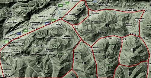
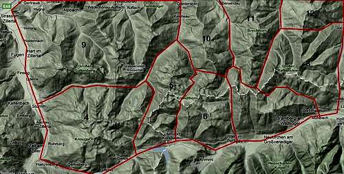
Ranges & Summits

I have summarized 218 summits within 14 Kitzbühel ranges. Some minor subsummits are not enlisted, some major subsummits are counted with their main summits. The denomination of the ranges follows the guide book of Bleier / Kettner (see the “Maps & Guide Books section). The numbers of the summits show their geographical position on the maps.
Kelchsauer Alpen
 Kelchsauer Alpen - northern part |
 Kelchsauer Alpen - southern part |
Kreuzjoch-Torhelm range
76. Kreuzjoch (2558 m)
77. Karspitze (2264 m)
78. Richbergkogel (2278 m)
79. Gamsköpfl (2476 m)
80. Isskogel (2263 m)
81. Rifflerkogel (2496 m)
82. Südlicher Katzenkopf (2539 m)
92. Schartenjoch (2217 m)
91. Speickspitze (2326 m)
90. Manskirch (2392 m)
83. Torhelm (2495 m)
85. Schwarzer Bär (2284 m)
84. Kastenwendkopf (2329 m)
86. Niederjochkogel (2145 m)
87. Regenfelderjoch (2258 m)
88. Grubachkogel (2343 m)
89. Pallspitze (2389 m)


Salzachgeier range
95. Ochsenkopf (2470 m)
109. Königsleiten (2315 m)
96. Falschriedel (2420 m)
110. Müllachgeier (2253 m)
97. Kleefeldkopf (2348 m)
98. Westlicher Salzachgeier (2469 m)
99. Östlicher Salzachgeier (2466 m)
100. Fünfmandling (2403 m), Gamsspitze (2393 m)
101. Schwebenkopf (2354 m)
102. Aleitenspitze (2449 m)
103. Schafsiedel 2447 m)
104. Herzogkogel (2292 m)
105. Stanglhöhe (2276 m)
106. Dürnbergstein (2204 m)
107. Foischingköpfl (2098 m)
108. Kreuzjoch (2071 m)
Kröndlhorn range
121. Ronachgeier (2236 m)
120. Baumgartgeier (2392 m)
111. Tristkopf (2359 m)
112. Kröndlhorn (2444 m)
113. Kröndlberg (2440 m)
114. Kapserkopf (2153 m)
115. Mitterkopf (2305 m)
116. Freimöserkopf (2007 m)
117. Grünkopf (1964 m)
122. Sonnwendkogel (2288 m)
123. Laubkogel (2317 m)
124. Gernkogel (2267 m)
118. Molterfeldspitze (2249 m)
119. Schneegrubenspitze (2249 m)


Geigen range
125. Steinkogel (2299 m)
126. Gamskogel (2206 m)
127. Speikkogel (2232 m)
128. Geige (2071 m)
129. Großleitkopf (2158 m)
130. Hüttenkogel (2180 m)
131. Trattenbacheck (2063 m)
132. Frühmesser (2233 m)
133. Braunkogel (2167 m)
134. Wildkogel (2225 m)
Rettenstein range
135. Großer Rettenstein (2362 m)
145. Spießnägel (1880 m)
136. Laubkogel (2114 m)
137. Kleiner Rettenstein (2217 m)
138. Roßgruberkogel (2156 m)
144. Resterhöhe (1894 m)
143. Latschinger Kogel (1989 m)
142. Zweitausender (2005 m)
139. Bärenbadkogel (1881 m)
140. Talsenhöhe (1928 m)
141. Wurzhöhe (1738 m)


Alpbach - Wildschönau range
165. Gratlspitze (1894 m)
146. Grasbergjöchl (1541 m)
147. Latschenkopf (1733 m)
148. Thaler Kogel (1691 m)
150. Widersberger Horn (2127 m)
153. Gamskopf (2203 m)
154. Tristenkopf (2203 m)
155. Großer Galtenberg (2424 m)
156. Kleiner Galtenberg (2318 m)
152. Tapenkopf (2266 m)
181. Mareitkopf (2003 m)
158. Torkopf (2116 m)
159. Hamberg (2095 m)
151. Sagthaler Spitze (2241 m)
161. Reitherkogel (1336 m)
162. Schatzberg (1901 m)
163. Joelspitze or Ackerzint (1964 m)
164. Saupanzen (1956 m)
166. Lämpersberg (2297 m)
167. Kleiner Beil (2196 m)
168. Seekopf (2187 m)
169. Großer Beil (2309 m)
170. Gamskarkopf (2242 m)
171. Gressenstein (2216 m)
172. Sonnenjoch (2287 m)
160. Kragenjoch (1425 m)
149. Möslalmkogel (1105 m)
157. Markbachjoch (1497 m)
173. Roßkopf (1731 m)
174. Turmkogel (1662 m)
175. Feldalphorn (1926 m)
176. Schwaiberghorn (1990 m)
178. Breitegg (1985 m)
177. Wildkarspitze (1961 m)
179. Kleinenberger Niederhorn (1866 m)
180. Hengstkogel (1803 m)


Kelchsau - Windau range
182. Glantererkogl (1473 m)
183. Lodron (1925 m)
184. Ramkarkopf (2063 m)
185. Steinbergstein (2215 m)
186. Haldenstein (2073 m)
Windau - Sperten range
199. Nachsöllberg (1886 m)
197. Fleiding (1892 m)
198. Laubkogel /1765 m)
188. Gampenkogel (1956 m)
187. Gaisberg (1767 m)
189. Brechhorn (2031 m)
190. Floch (2057 m)
191. Gerstinger Joch (2037 m)
192. Kleiner Tanzkogel (1974 m)
193. Großer Tanzkogel (2097 m)
194. Schwarzkarkogel (2089 m)
195. Westerachkogel (2090 m)
196. Gamsbeil (2168 m)
Sperten - Jochberg range
200. Hahnenkamm (1655 m)
201. Steinbergkogel (1971 m)
202. Pengelstein (1939 m)
03. Schwarzkogel (2030 m)
Pölven
210. Kleiner Pölven (1564 m)
209. Schwoicher Pölven (1554 m)
208. Großer Pölven (1594 m)


Hohe Salve - Zinsberg range
204. Hohe Salve (1827 m) / Kleine Salve (1559 m)
205. Zinsberg (1674 m)
207. Rauher Kopf (1580 m)
206. Hartkaser (1555 m)
Glemmtaler Alpen

Glemmtal main range


23. Kuhkaser (2054 m)
17. Geißstein (2363 m), Kitzstein (2033 m)
16. Leitenkogel (2075 m)
18. Rescheskogel (2183 m), Rinnkogel (2147 m)
19. Maurerkogel (2125 m)
20. Sintersbachhöhe (2027 m)
21. Schellenberg (2048 m)
22. Schöntagweidkopf (2013 m)
15. Mittagskogel (2094 m)
14. Manlitzkogel (2247 m), Pihappenkogel (2118 m)
13. Rabenkopf (2075 m)
12. Lamperbühelkogel (2036 m)
10. Sonnberg (2187 m)
11. Bärensteigkogel (2225 m)
9. Medalkogel (2122 m)
8. Hochsaalbachkogel (2212 m)
7. Hochkogel (2249 m)
6. Zirmkogel (2214 m)
4. Oberer Gernkogel (2176 m)
5. Niederer Gernkogel (2153 m)
3. Maurerkogel (2074 m)
2. Kettingkopf (1886 m)
1. Schmittenhöhe (1965 m)
24. Sonnkogel (1856 m)
25. Wankrautkopf (1762 m)
Glemmtal subranges
31. Hoher Penhab (2112 m)
32. Zwölferkogel (1984 m)
30. Stoffenwand (2124 m)
29. Schattberg Westgipfel (2095 m), Ostgipfel (2018 m)
28. Stemmerkogel (2122 m)
27. Saalbachkogel (2091 m)
Glemmtal range north


69. Kitzbüheler Horn (1996 m)
66. Hornköpfl (1722 m), Wilde Hag (1639 m)
68. Pfeiferkogel (1669 m)
75. Karstein (1922 m)
67. Hochetzkogel (1738 m)
65. Stuckkogel (1887 m)
64. Brunnerkogel (1746 m), Gaisberg (1786 m)
63. Gebra (2057 m)
74. Lärchfilzkogel (1654 m)
73. Wildseeloder (2117 m), Platte (1903 m)
72. Henne (2076 m), Hochhörndlerspitze (1981 m)
72. Hoher Mahdstein (2062 m)
71. Niederer Mahdstein (1901 m)
62. Bischof (2127 m)
61. Mesnerhöhe (2051 m)
60. Sonnspitze (2062 m)
49. Spieleckkogel (1998 m)
48. Kastelstein (1931 m)
59. Staffkogel (2115 m)
58. Rauber (1973 m), Hahnenkampl (1813 m), Laubkogel (1760 m)
57. Saalkogel (2007 m)
56. Tristkogel (2095 m)
55. Kleiner Schütz (2079 m), Großer Schütz (2069 m)
54. Gamshag (2178 m)
53. Teufelssprung (2174 m)
52. Schusterkogel (2208 m)
46. Hochalmspitze (1921 m)
47. Reichkendlkopf (1942 m)
45. Reiterkogel (1819 m)
42. Maisereck (1675 m)
44. Barnkogel (1709 m)
50. Spielberghorn (2044 m)
51. Bürglkopf (1730 m)
40. Kohlmaiskopf (1794 m)
39. Mardeckkopf (1817 m)
38. Pründelkopf (1881 m)
37. Wildenkarkogel (1910 m)
36. Astitzkogel (1914 m)
35. Schabergkogel (1888 m)
34. Funeck (1805 m)
33. Haiderbergkopf (1875 m), Sausteigen (1912 m)
Mountain Activities
Hiking
Hiking is one of the main mountain activities within Kitzbüheler Alpen. There is an abundance of hiking trails in the valleys, across cols and notches, linking valleys or mountain huts, and leading on the many summits and peaks. Near the valley grounds many routes follow forest roads. In some valleys, however, the old Alm trails are still maintained and marked as an alternative to the mostly boring forest roads. Official trails and routes are marked and signposted (yellow signposts).
Don´t trust the indications of walking hours on these signs, they are sometimes too long, some-times too short .....
As the landscape is open in the higher regions you can choose easily your own off-trail route across ridges or for shortcuts. I made innumerable ridge traverse epics, bagging three, four, five and more summits in one day, sometimes with interesting rock scramble and mixed off-trail terrain and then returning to a lush Alm meadow with several crystal clear springs and many wildflowers. Nearly everything is possible. For all hiking activities a good map is advisable.

Climbing
As there are many meadow and "scrambling" summits, climbing is not among the major mountain activities in Kitzbüheler Alpen. The surroundings of Großer Rettenstein bear some interesting climbing routes, however, as this region has some high and steep rock faces.
Mountain Biking
There are about 55 official mountain bike routes with more than 800 km length within Kitzbüheler Alpen. Kitzbüheler Alpen is one of the rare regions with the „approved bike area"-seal of quality. TransKitzAlp is a four day mountain bike route with 5.400 meters of altitude difference:
Many cablecars have official (and secret) downhill trails, e.g.
Good overview (in German language)

Ski Touring and Snowshoe Hiking
There is hardly any region with more ski tour routes than Kitzbüheler Alpen. Due to the open landscape and the nearly complete absence of steep rock summits, the presence of many cirques, broad ridges and vast Alm meadows, nearly every summit has more than two ski tour route possibilities.
Most ski tours can be done starting from a valley ground with a moderate elevation gain (1000 meters to 1400 meters). Some peaks, however, are more remote and can be be better summited when starting from one of the mountain huts which are open in late winter / spring or offer an open winter facility room.
Many ski routes can be done as well with snow shoes. Please don´t destroy the ski tour ascent tracks with you snow shoes.
The avalanche danger often is a bit lower than in other regions but don´t rely on that common rule without checking the avalanche bulletin.

Cross country skiing
There are 580 km of cross country skiing routes within Kitzbüheler Alpen. Most of them are not very difficult with no or only moderate grades. At many starting points you have facilities like locker rooms, showers and restaurants. Most routes and many ski busses are free, some routes require a fee to be paied at the starting points.
Sled routes
As Kitzbüheler Alpen are a major tourist region many villages do have their sled routes, too, to entertain winter tourists.

Winter hiking trails
There are over 100 km of cleared hiking trails mainly in the valleys on which you can walk for hours and make interesting loop routes. All these routes are marked and signposted. The use of some ski busses, providing access to some trailheads, too, are free of charge.
Ski areas
The main ski areas within Kitzbüheler Alpen are as follows:
- Wilder Kaiser, Söll, Elmau, Scheffau, Brixental, a huge ski area around Hohe Salve and Zinsberg, with the villages Söll, Scheffau, Elmau, Hopfgarten, Westendorf and Brixen im Thale
- Sankt Johann in Tirol nice ski area on the north and west side of Kitzbüheler Horn
- Kitzbühel the VIP ski area around Hahnenkamm (with the famous Streif downhill race) and Kitzbüheler Horn.
- Kirchberg / Tirol neighbour ski area to Kitzbühel and much more relaxed ...
- Fieberbrunn the north-ern slopes of Wildseeloder with great views to Leoganger and Loferer Steinberge
- Saalbach - Hinterglemm a huge ski area in the eastern Kitzbüheler Alpen, connected with Saalfelden am Steinernen Meer and Leogang
- Zell am See, Schmittenhöhe, together with Kaprun and the famous Kitzsteinhorn in the Großglockner area a huge ski area.
- Neukirchen am Großvenediger / Zillertal Arena together with Gerlos, Krimml, Wald / Königsleiten and Zell am Ziller another huge ski area on the south side of Kitzbüheler Alpen
- Alpbachtal - Wiedersberger Horn is a nice ski area within Alpbachtal / Kitzbüheler Alpen
- Wildschönau Schatzberg is a family ski area in one of the most beautiful valleys of Kitzbüheler Alpen: Wildschönau. Despite of this huge amount of ski areas you find many remote and lonely regions within Kitzbüheler Alpen for ski tours.
Red Tape

Kitzbüheler Alpen are surrounded by important nature protection areas and national parks - Nationalpark Hohe Tauern to the south, - Nature protection reserve Kaisergebirge to the north Kitzbüheler Alpen, however, are not protected as a complete mountain area.
There are, as far as I know, only two protected locations:
- Wasenmoos - Schutzgebiet, an interesting alpine moor near Mittersill / Pass Thurn
- Landschaftsschutzgebiet Spertental
Some remote valley roads are toll roads and are closed in winter. Please use the parking areas even if they are with a days fee - people try to channel the sometimes heavy tourist traffic in the valleys. Some ski tour and snow shoe ascent and descent routes are marked so to preserve plants, young wood and animals - please follow these routes if they are set up. In some cases mountain biking is restricted. Forest roads or Alm meadows may be prohibited for mountain bikers - please respect this, too.
Current Weather
Weather Kitzbühel:
Weather Kreuzjoch-Torhelm range:

Maps & Guide Books
Maps
Austrian Topo Maps: Österreichische Karte 1 : 50.000 - UTM (ÖK50):

Other Topo Maps:
Guide Books
Available only antiquarian but an indispensable mountain guide book:
The same:
Water
Kitzbüheler Alpen are a region full of water. Lakes, creeks, ponds, waterfalls, highmoors everywhere. The quality of the water, however, is poor in the zones below and around the Alm huts. The intensely livestock farming causes a lot of slurry which is spread by huge "irrigation guns" over the meadows and pastures of the Alm zone.
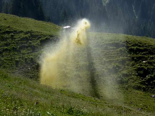 Slurry irrigation within the Alm zone of Kitzbüheler Alpen Slurry irrigation within the Alm zone of Kitzbüheler Alpen |
[
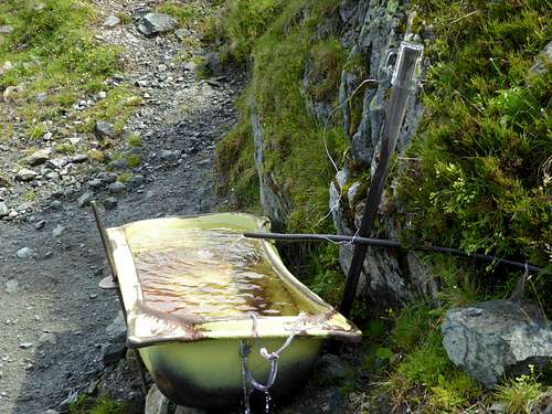 Drinking water, indicated with a beer glas at the well Drinking water, indicated with a beer glas at the well |
Above this zone running water can be used for resupply without restriction. Only the beautiful ponds on the ridges of Kitzbüheler Alpen may be doubtful ..