
-
 5554 Hits
-
 84.27% Score
-
 18 Votes
|
|
Mountain/Rock |
|---|---|
|
|
47.33312°N / 12.29600°E |
|
|
Hiking, Mountaineering, Trad Climbing, Skiing |
|
|
Spring, Summer, Fall, Winter |
|
|
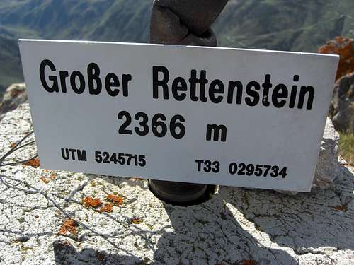
7762 ft / 2366 m |
|
|
Overview
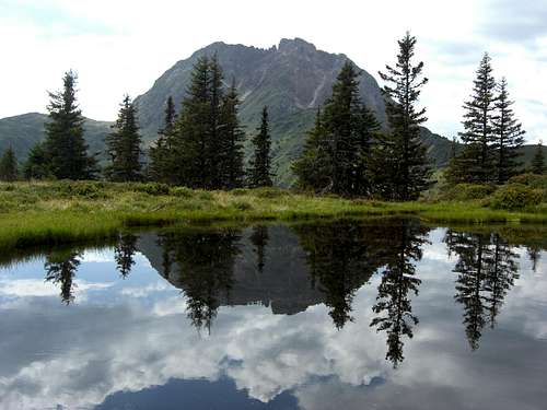
Großer Rettenstein and Hirzegg pond
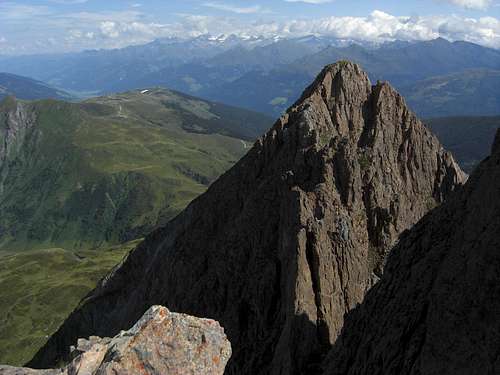
Großer Rettenstein is by far the most eye-catching summit of the whole Kitzbüheler Alps. It is a bold rock spire when viewed from the north or the south and a huge rock face with turrets and needles when viewed from the east or the west. The whole rock rises about 400 m above the surrounding green hills and ridges and is simply a striking feature among Kitzbüheler summits. Consequently it is one of the most desired outings within this range.
Geologically Großer Rettenstein is a huge dolomite block sitting on the quartz phyllite beds which are so dominant in the whole of the range. This dolomite has Silurian age and can be found in other regions of the range, too, but only Großer Rettenstein is this highly visible landmark.
Despite of its dominant appearance Großer Rettenstein is not among the highest peaks of Kitzbüheler Alpen; the summit is nearly 200 m lower than the highest Kitzbühel summit, Kreuzjoch.
There are hiking routes from the north and the south leading to the summit block and the eastern normal route up to the highest peak of this multi – summit mountain. The normal route is steep and has some easy rock scrambling and some short UIAA grade I moves involved.
The west wall of Großer Rettenstein offers many climbing routes.
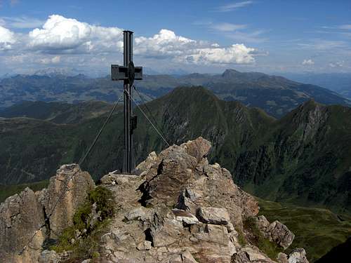
 Großer Rettenstein summit Großer Rettenstein summit |
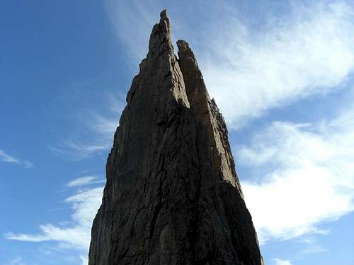 Großer Rettenstein summit spire Großer Rettenstein summit spire |
In winter or spring Großer Rettenstein is visited by experienced ski mountaineers even though the mountain is not among the classic ski touring summits of Kitzbüheler Alpen. The route follows the summer normal route, is steep and dangerous in its upper parts and needs a lot of snow to cover the many rocks and ledges of the east slope.
Großer Rettenstein is among my favourites of the Kitzbühel range. On clear days the summit offers spectacular views in all directions and the traverse Spießnägel – Großer Rettenstein is for sure among the most inspiring hikes Kitzbüheler Alps can offer.
Getting There
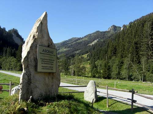
Aschau / Spertental trailhead
Trailheads for Großer Rettenstein are:
You reach Aschau via road number L 203 from Kirchberg / Tirol.
Kirchberg is located near Kitzbühel. Leave the highway A 12 München – Kuftsein – Innsbruck – Landeck at exit Wörgl, follow road number 178 shortly and go on road number 170 to reach Kirchberg from western directions.
From eastern directions follow road number 168 to Saalfelden, Fieberbrunn and Sankt Johann, turn on road number 161 to Kitzbühel and on road number 170 to Kirchberg.
The parking areas are located at the beginning of the two valleys Unterer Grund and Oberer Grund which split up at Aschau at the end of Spertental.
Go on L 203 until you pass by Oberlandhütte (alpine club hut) and follow the road to a road junction: the left (dirt) road goes into Oberer Grund (parking area after about 500 m), the road straight on goes into Unterer Grund (parking area about 300 m further on).
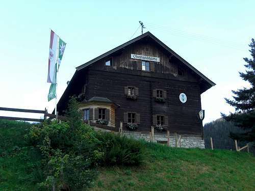
Oberlandhütte
The southern trailheads / parking areas are within Pinzgau valley between Kitzbüheler Alps and the glaciated Großvenediger group. The villages are alongside road number 165 and can be reached from Innsbruck via highway A 12 to exit Jenbach / Zillertal, road number 169 to Zell am Ziller and road number 165 via Gerlospass.
The eastern approach goes from Kitzbühel via Pass Thurn on road number 161 to Mittersill and on road number 165 to the trailheads.
From Salzburg / Bad Reichenhall directions take road number B21 and 178 to Lofer, road number 311 to Saalfelden and Zell am See, road number 168 to Mittersill and 165 to the trailheads.
Main Routes
There are two northern main routes which can be combined to a nice traverse.
Direct Northern route
Follow the toll road into Unterer Grund until a trail branches off to your left (signposts, about 900 m from the parking area). Ascend the trail to Sonnwendalm where you meet a forest road. Follow that forest road up to Schöntalalm and further on into Schöntal. You the will reach Schöntal Scherm at a height of about 1660 m, an old and abandoned Alm hut, where the forest road ends.
 Schöntal Scherm Schöntal Scherm |
 Upper Schöntal Upper Schöntal |
 Summit slope Summit slope |
Follow the trail starting at Schöntal Scherm up to a trail junction. Take the right hand trail which brings you up to the lower east slopes of Großer Rettenstein. The trail steepens and zigzags up to another trail junction where the Spießnägel - Rettenstein traverse route joins.
The trail keeps steep and steady upward until it reaches the first rocks of Rettenstein summit block. Scramble up to a shoulder in a northeast subridge and follow the route into the upper cirque of Großer Rettenstein below the spires and rockwalls of the long, south-north running summit ridge. You reach a narrow notch with a great view down the western rock faces of the mountain and into the glaciers of Hohe Tauern ranges.
 Upper Schöntal and Rettenstein Upper Schöntal and Rettenstein |
 Rock window near the summit Rock window near the summit |
 Summit block Summit block |
Turn right there and scramble up to the summit ridge (some steps UIAA grade I). There is a small rock window with another great view to the northeast. Follow the summit ridge over some exposed but easy rocks to the near summit.
Spießnägel - Rettenstein traverse route
This route includes a traverse of Spießnägel and is one of my favourites within Kitzbüheler Alps.
Follow first the forest road into Oberer Grund, starting from the parking area. After about 1 km you reach a road junction with signposts: take the right hand road which zigzags up the lower east slope of Spießnägel. The road ends at a height between 1300 m and 1400 m and a trail continues zigzagging up the wooden slopes. It ends at another forest road at about 1500 m; turn right on that road and follow it until you reach the Hirzegg Alm, one of the real old Alm huts of Kitzbüheler Alpen, where you get food and drinks.
 Ascent to Hirzeggalm Ascent to Hirzeggalm |
 Ascent to Spießnägel Ascent to Spießnägel |
 Traverse ridge Spießnägel - Rettenstein Traverse ridge Spießnägel - Rettenstein |
The route follows now the forest road going south from the Hirzegg Alm until it ends at a hunters cabin. Before you hit that cabin turn right onto a smaller and old Alm road and follow it until it ends and a trail starts to your left to ascend steeply the meadows of the upper slopes of Spießnägel. This trail goes up to the north ridge of Spießnägel; turn left on the ridge and follow the trail up to the summit cross of Großer Spießnagel.
Follow the Spießnägel ridge, first in some ups and downs, then descending shortly into Hirzegg col with the homonymous lake. The trail follows the ridge to the south, ascending again and passing by some small lakes and ponds. You pass by Rettenstein col (1928 m) and reach a hilltop (about 2050 m) in fromt of the big, huge summit rock wall of Großer Rettenstein. Descend over meadows into the Schöntal col (2020 m) to a trail junction. Here the Wildkogel - Rettenstein route and the Bicheln - Mühltal route join with the traverse route.
 Spießnägel, view of Spertental Spießnägel, view of Spertental |
 Pond on the traverse ridge Pond on the traverse ridge |
 Summit view to Spertental Summit view to Spertental |
Take the trail to your right and traverse the eastern slopes of Großer Rettenstein until you reach the trail junction with the direct northern route. Follow this route as described above.
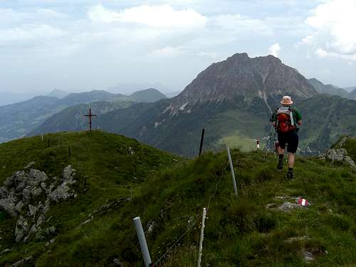
 South summit South summit |
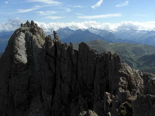 Summit ridge and Großvenediger mountains Summit ridge and Großvenediger mountains |
South routes
Wildkogelbahn mountain station – Frühmesser – Laubkogel – trail junction with Spießnägel route at Schöntal col – Großer Rettenstein or
Bicheln/ Pinzgau – Mühlbach valey – Stangen col - trail junction with Spießnägel route at Schöntal col – Großer Rettenstein
Climbing routes
Climbing routes overview
South pillar: UIAA grade IV
Summit ridge (from the north to the south summit): UIAA grade III
Wilde Frauen: UIAA grade III
Western Buttress: UIAA grade VI-
Southwest edge: UIAA grade V+
Rettensteindach: UIAA grade A2/IV+
Southwest buttress: UIAA grade IV
Southwest wall: UIAA grade V/V+
Evitutten: NW UIAA grade V+/VI-
Speedy Gonzales: UIAA grade VI-
Hexentanz: UIAA grade V+
Hufeisen: UIAA grade V-
Old Man: UIAA grade V/V+
Cassandra: UIAA grade VIII
Variation of Western Buttress: UIAA grade VI-
Red Tape
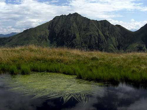
Pond on traverse ridge from Spießnägel with Kleiner Rettenstein
The Rettenstein area is a landscape protection area.
There are no special restrictions as far as I know.
Respect the rough beauty of the landscape of Spießnägel / Rettenstein area; there are many rare wildflowers and plants on the meadows and many amphibians dwelling in the small lakes and ponds and swamps of the area.
Aschau im Spertental and Kirchberg have many facilities for accommodation.
Oberlandhütte is a alpine club hut and offers meals also for those who will not stay overnight.
Hirzeggalm offers food and drinks.
When to Climb
Summit view
Großer Rettenstein is mainly a late spring, summer and autumn outing. It is a long hike with some rock scrambling and some UIAA grade I moves near the summit which requires normal hiking gear, good shoes and, if you like, hiking poles. The routes never exceed UIAA grade I, the trails are in some parts narrow and cut in steep slopes.
The traverse of the Spießnägel requires some short easy rock scrambling.
Großer Rettenstein is not a typical ski touring summit. With good snow conditions experienced ski mountaineers can tackle Großer Rettenstein in winter / spring, too. You mainly follow the direct northern route to the summit. The summit slope is very steep (> 45 degrees) and needs much and good snow to cover most of the rocks
Current Weather:
Maps & Guide Books
Maps
Austrian Topo Maps:
Österreichische Karte 1 : 50.000 - UTM (ÖK50):
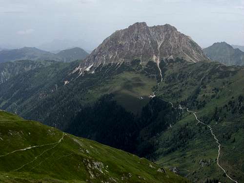 Großer Rettenstein as seen from Gamsbeil Großer Rettenstein as seen from Gamsbeil |
 Großer Rettenstein as seen from Westerachkopf Großer Rettenstein as seen from Westerachkopf |
Other Topo Maps:
Guide Books
Available only antiquarian but an indispensable mountain guide book: