
|
|
Mountain/Rock |
|---|---|
|
|
41.81495°N / 111.6374°W |
|
|
Cache |
|
|
Hiking |
|
|
Spring, Summer, Fall, Winter |
|
|
7427 ft / 2264 m |
|
|
Overview
Jardine Juniper Peak is the unofficial name given to an otherwise mediocre peak that gains its notoriety solely from The Old Jardine Juniper Tree that resides on its eastern slopes. The Old Jardine Juniper Tree is one of the most popular destinations in the Logan Canyon area. Don't let the popularity deter you from visiting this peak. The summit itself rarely sees visitors as most of the crowds will be drawn to the juniper tree. The scenery along the trail is breath-taking. This is rewarding enough to make a few hours of your day surprisingly pleasant. Perfect for spring conditioning, Jardine Juniper Peak serves well as a preview peak for the high peaks surrounding Logan Canyon. Jardine Juniper Peak will leave you drooling for more of what the spectacular Bear River Mountains have to offer its mountain adventurers.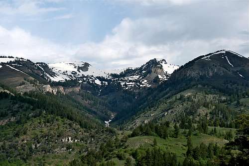 South Fork Cottonwood Canyon & Mt. Elmer
 Features
Reasons to visit: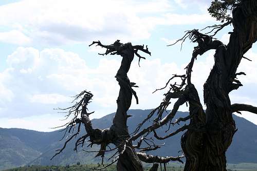
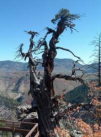
The Old Jardine Juniper Tree
This is the oldest Rocky Mountain Juniper you will ever see...
...and possibly the weirdest looking

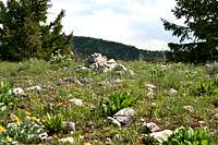
Fantastic Scenery
When To Go
 Logan Peak
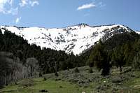 Peak 9065
Due to the lower elevation, hiking opens up earlier in the spring than the surrounding peaks. This area is accessible year round.
Getting There
 photo by mountaingazelle
Red Tape
This trail is found in the Cache National Forest, but does not traverse any wilderness area. You may be sharing the trail with mountain bikers and horses.Visit the home page of the Uintah-Wasatch-Cache National Forest
Please contact the Logan District Office for further information:
Logan Ranger District
1500 East Highway 89
Logan, UT 34321
(435) 755-3620
Current Conditions
Here's some useful links:Avalanche conditions around Logan City
Wildfire Information for Utah
Road Conditions in the State of Utah
Weather Forecast from NOAA
Maps and Peak Data
USGS Maps: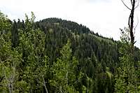 Jardine Juniper Peak
Mt. Elmer, UT 1:24,000
Logan, UT 1:100,000
Elevation: 7,427 feet
Prominence: 647 feet
Isolation: 3.3 miles
Utah Rank: 1833
Cache County Rank: 62
County Prominence Rank: 24
Camping
 Peak 7214
Campgrounds abound in Logan Canyon. There is a campground at Wood Camp Hollow on the same turnoff as the trailhead. It has tables and fire pits with grills.
Backcountry
There is ample space for backcountry camping in Wood Camp Hollow. There is plenty of level terrain. A nice, shady creek flows through the canyon, which would make a nice source of water for a campsite.
Accomodations
The city of Logan has many rooms and dining services. There are also sporting goods stores with all the necessary gear and maps for the area.
Route
Trailhead Elevation: 5,420 ft.Peak Elevation: 7,427 ft.
Distance: Slightly more than 5 miles one way
Facilities: Restroom at trailhead and nearby campground
Water: The creek has plenty of water
Since there is really only one sensible route up this peak, I will post the route information on this main page. Most of the mountain is surrounded by hazardous cliffs. Only the west side of the peak is accessible for hikers. This is where the Jardine Juniper Trail is found.
The Jardine Juniper Trail is very easy to follow and very mild in grade. The trail should be shaded in the early morning or in the evening. The trailhead notes a distance of 5.3 miles to the Jardine Juniper Tree. There are a few signs along the trail to help keep hikers moving in the proper direction. Although the trail climbs over 2,000 feet, this is very gradual until you must leave the trail in order to reach the top of the mountain. Even this does not entail much bushwhacking. Thus, this hike provides a very enjoyable, and mild peakbagging experience. This might be ideal for taking the kids out or for an early season conditioning hike. Slow hikers should reach the top in under three hours.
 Wood Camp Creek
The trail begins by following the Wood Camp Hollow Creek up toward the upper part of the canyon. The stream is banked by cottonwood trees in the lower part of the canyon. There will be some segments of open terrain, dominated by sagebrush until you reach the upper portion of the canyon. There will be three stream crossings on this portion. Two of them are nothing to worry about, but the third crossing requires a bit of a balancing act when the creek is high. See the photo for the primitive log bridge that has been built.
Soon, the trail begins to climb the southwest bench of Peak 7214 using a series of long switchbacks. There are a few more springs runoffs to step over along the trail, but they are nothing serious. This part of the hike is quite shady with aspen, douglas fir and junipers. Eventually, the trail crosses over to the opposite side of the southern ridge. You will be heading toward a saddle between Peak 7214 and Jardine Juniper Peak. The forest is much more open and the saddle provides some great views of Wood Camp Hollow and Cottonwood Canyon. Taking a trail into Cottonwood Canyon puts you into the Mt. Naomi Wilderness Area. But, our trail never diverges into that territory. Take a moment to soak up the atmosphere and the views on the saddle. A small rest bench has been built to accommodate you.
 Beirdneau Peak
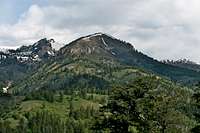 Peak 9188
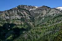 Peak 9065
This map shows the approximate route that can be taken.
<
View Jardine Juniper Peak Trail in a larger map">Jardine Juniper Peak in a larger map
As you continue along from the saddle you will turn to the southeast and take a route along the southwest slopes of our desired peak. This segment begins with shade, but it eventually opens up to a nice open section where you will catch incredible views of the Wood Camp Canyon, as well as views of all the surrounding major peaks in the area. Logan Peak, Beirdeau Peak, and Mt. Elmer can all be seen. This may be the best view along the whole trail. The trail eventually splits up and takes a full circle around the mountain. Either direction will eventually take you to our desired destination, either the peak, the old tree, or both. Both routes also maintain roughly the same elevation. The only difference, as a trail sign describes is, go right for the scenic route, or go left for the shady route. I recommend taking the scenic route on the way up, and then circling around using the shady route on the way back.
 Summit
 Final Ascent
Old Jardine Juniper Spur Trail
 Old Jardine Juniper photo by mountaingazelle
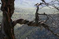
The Old Jardine Juniper is the oldest known surviving Rocky Mountain Juniper. The sign near the tree estimates that it is near 3200 years old. It was named after William M. Jardine, who was US Secretary of Agriculture during the 1920s and was a graduate of the nearby Utah State Agricultural College in Logan City. The conservation corps has built a couple of benches near the tree and a trail register.
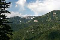
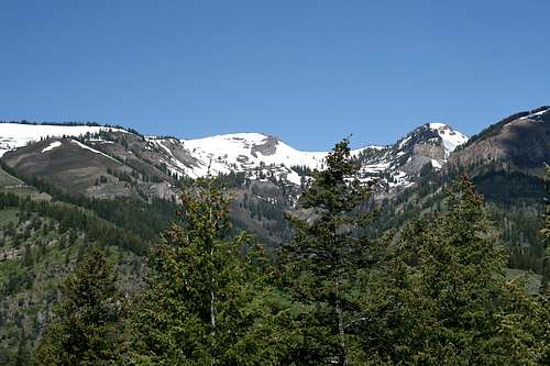 Mt. Elmer from the summit
Flora and Fauna
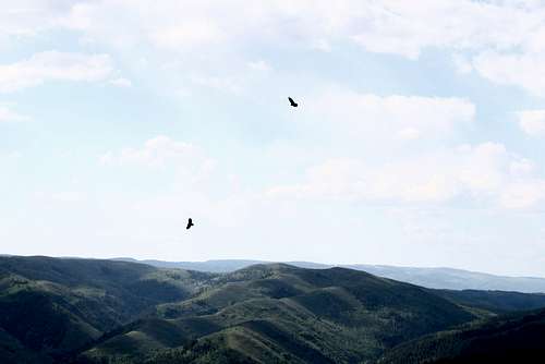 Pair of Hawks
The trees found along this hike are a mix of aspen, Douglas fir, Junipers and cottonwoods. The most famous of all these is the Old Jardine Juniper found near the summit of Jardine Juniper Peak. This is the oldest known surviving Rocky Mountain Juniper, estimated at up to 3000 years old, depending on the source.
Wildlife is abundant in Logan Canyon and in the Wood Camp Hollow area. The wildlife on this hike is typical for the area. Black bears and moose would be the biggest animals you might see on the hike. The author sighted a moose near the saddle and a pair of hawks over the peak.
Logan River is also a great trout fishery and is popular for fly-fishing.