
|
|
Mountain/Rock |
|---|---|
|
|
42.09477°N / 111.58076°W |
|
|
Franklin |
|
|
Hiking |
|
|
Spring, Summer, Fall, Winter |
|
|
9484 ft / 2891 m |
|
|
Overview
The Franklin County High Point is an unnamed peak on the Franklin/Bear Lake County line at 9484 ft. Most people believe Wilderness Peak to be the highest point in the county but this is untrue. Wilderness Peak, although more well known and more dramatic sits at 9460 ft, just 24 feet shorter than the actual high point. This mountain sits at the North end of Egan Basin, just to the East of Danish Pass. It is very seldom climbed because it is quite an obscure mountain. Really the only ones who ever reach the top (or even try for that matter) are County High Pointers.The Highline Trail also runs from Egan Basin to the ridge just West of the peak and is a very good trail.

Sunrise near the highpoint.
The view from the top is actually quite spectacular. To the South almost the entire main crest of the Bear River Range is visible from Mt. Magog to Wilderness Peak. Doubletop appears to be the most prominant from this angle. To the North all of the major Bear River peaks in Idaho are visible as well from Cub Peak and St. Charles Mountain to Sherman Peak.

The Summit Plateau

The Actual High Point
The summit is just the high point of a forrested and rocky ridge. It sits on the Northern end of the ridge overlooking Snowslide Canyon and St. Charles Canyon. Just to the West and immediately below the summit is a bowl shaped feature with grass, rocks, and ancient tress where deer and other animals live. It is a very beautiful and quiet place and you are almost guaranteed that you will see no one else.
Getting There
The mountain can be approached from two directions, North and South. There is a los another possible approach via Snowslide Canyon on the Northwest but it would be a much longer hike as there is no road. The southern approach is long as far as driving time but they hike involved is the same and is very short.From the South
From either Logan or Bear Lake along highway 89 up Logan Canyon. From the highway turn off at Beaver Creek and continue past the campground and into Egan Basin. (The turn off will be farther from Logan and closer to Bear Lake along the road.) The mountain is at the very Northeastern edge of the Basin. Park just before the road turns to go through Danish Pass. This is the base of the mountian. The road from the South is good and cars are even possible to use on this road.
From the North
From Preston, Idaho go South on highway 91 and turn East on Cub River Road.
Follow the road for about 16 miles to the Willow Flat Campground. Once you get to the campground keep following the road to the South and across the Bridge. The road will the start to climb into Hillyards Canyon. The Canyon is about 6 miles long and ends in Franklin Basin. Continue on the Franklin Basin Road for about one or two miles til you come to the sign directing you to Egan Basin to the East. Take this road that winds through Danish Pass. From the pass descend and park just before the road turns to the South. The Mountian is just to the Northwest and looks like a rounded, Tree-covered Summit.
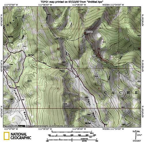
Map of FCOHP
The Climb
Since the mountain is not very steep many, many appraoches are possible. There is no trail to the summit though so any route you choose will be a bushwhack. The Highline Trail runs to the top of the ridge just West of the mountain seperating Egan Basin from Snowslide Canyon. The trail continues to the North but you can leave the trail at the top of the ridge and work your way East and to the top following this ridge. This is the most common route.
It can also be climbed from the South. There is no trail at all in this direction and the climb is a little longer and steeper. There are a few rocky spots on either of the approaches that you must work around but nothing technical. Everything can be avoided by hiking around it.
Red Tape
The approach from the North, although shorter, is VERY hard on vehicles. Hillyard's canyon is steep, narrow, and rocky, and has deep ruts that will require and high clearence vehicle with 4 wheel drive.
Glowing Trees at Sunrise
No permits are required.
Bring water as there is none near the peak.
There will always be cattle wandering around so be prepared to encounter them.
Camping
There are two excellent campgrounds located nearby. Willow Flat on the North, at the base of Hillyards Canyon, is very large and has many facilities. It is located at the end of Cub River Canyon.Beaver Creek Campground is also another large and popular campgound to the South of Egan Basin. The roads are good to these campgrounds.
There are also many well used but unofficial camping places throughout Franklin and Egan Basins, including one at the base of the mountain where you park to climb.
bjornironside - Feb 9, 2011 4:14 am - Hasn't voted
St. Charles PeakThis peak is usually referred to as St. Charles Peak, I have no idea why they don't label it as such on topo maps, but when locals say they're going to the top of St. Charles Peak, everyone knows what they're talking about
mtybumpo - Feb 9, 2011 11:57 am - Hasn't voted
Re: St. Charles PeakI've lived in Preston most of my life and I've always known the peak above Bloomington Lake as St. Charles Peak. http://www.summitpost.org/saint-charles-mountain/313115 Some people call FCHP "The Felt Hat" But I've never heard anyone refer to it as St. Charles. They're always talking about the peak mentioned above when they do.