
-
 11199 Hits
-
 81.84% Score
-
 14 Votes
|
|
Mountain/Rock |
|---|---|
|
|
38.28500°N / 78.731°W |
|
|
Hiking |
|
|
Spring, Summer, Fall, Winter |
|
|
2760 ft / 841 m |
|
|
Overview and Route Description

Three ridges extend west from Rockytop, each forming a named mountain. From north to south, they are Lewis Peak, Lewis Mountain, and Austin Mountain. Austin Mountain has a rugged, poorly maintained trail over it that does not cross the actual summit, which has no unobstructed views, anyway. Lewis Mountain has no trail system on or over it at all.
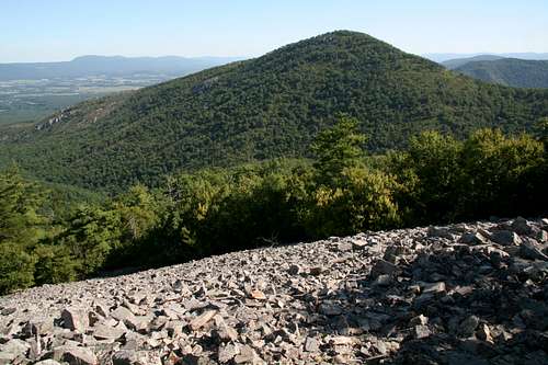
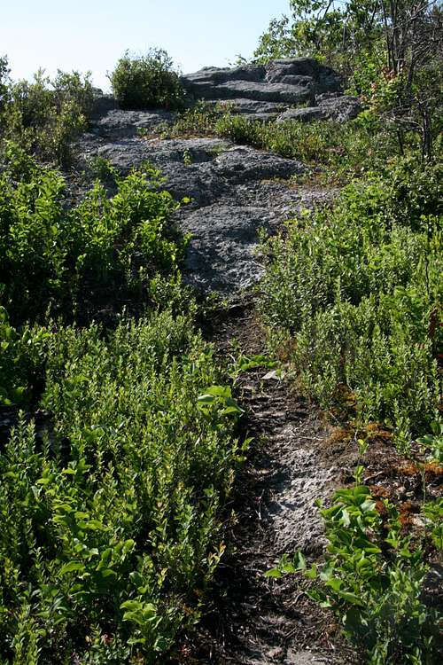
But Lewis Peak has a lightly used but decently maintained trail that goes very close to its summit, and the summit is a short walk away, though one must watch out for thorns and other brush, especially in “shorts weather.” The summit is rocky enough to be open and therefore provides 360-degree views. There are the familiar views of the Shenandoah Valley to the west, but there are also little-seen perspectives of Rockytop and other areas in and around the Big Run watershed, which may be Shenandoah’s wildest and least-explored trail-accessible region.
There are shorter trails in Shenandoah National Park that lead to views that are at least as good as those from Lewis Peak, so it is not for the casual hiker that wants a taste of what the park is about. Lewis Peak’s appeal is its remote location and the solitude that comes with that, and it is thus attractive to veteran SNP hikers who love the park but need to escape from the crowds and to other visitors who like wilderness with their hiking.
Another appealing trait of Lewis Peak is that it is one of a handful of SNP peaks where exposed outcrops of sandstone show fossilized wormholes that are estimated to be 500 million years old. Look for these along talus slopes and among the summit rocks. For more information about the wormholes, please see the Rockytop page.
Hiking to Lewis Peak
RT distance 9.4 miles, total elevation gain to summit app. 900’ (trails go up and down).
From Browns Gap, follow the Appalachian Trail for 0.6 miles as it ascends to the Big Run Portal Trail, and turn left at that junction. Follow the gentle descent for 0.7 miles to another intersection, and make sure to take the Rockytop Trail. This trail undulates for 2.2 miles, passing very close to Rockytop’s two false summits, until it intersects the Lewis Peak Trail (take it), which descends moderately steeply to a sag at the base of Lewis Peak and then begins to climb again. Along the way, there are two talus slopes on either side of the trail, and both provide nice views from what is otherwise a tree-shrouded trail. 0.9 miles from that last trail intersection, a marked spur leads 0.3 miles to within several yards of Lewis Peak’s summit, and then it is a matter of some easy rock-hopping and mild bushwhacking to reach the true highpoint (better to wear long pants or go in winter because of poison ivy and thorns, but I did this in August and lived).
Getting There
The TH is in the park’s South District at MP 82.9 (Browns Gap). From any entrance station other than the southernmost one (Rockfish Gap), drive south.Red Tape
It costs $15 to enter the park, and that provides access for a week. Annual passes cost $30. The interagency pass, good for yearlong entry to areas managed by NPS, USDA Forest Service, USFWS, BLM, and the Bureau of Reclamation, costs $80.It’s common sense to wear a helmet when climbing, anyway, but it’s especially important here since people at the top might toss rocks over the edge.
The park is open all year, but Skyline Drive does sometimes close after snow or ice storms. The park site does not give current road conditions, so call ahead (540-999-3500).
To reduce poaching, Skyline Drive is subject to closures during hunting season. The information below, copied and pasted from the park site, illustrates the 2006 restrictions—
From November 13, 2006, through January 6, 2007
Skyline Drive
• between Front Royal (Mile 0 at U.S. Highway 340) and Thornton Gap (Mile 31 at U.S. Highway 211), and
• between Swift Run Gap (Mile 65 at U.S. Highway 33) and Rockfish Gap (Mile 105 at U.S. Highway 250),
will be closed daily between 5:00 p.m. and 8:00 a.m.
The central portion of the Drive, between Thornton Gap and Swift Run Gap, will remain open for overnight access to Skyland Resort and Big Meadows Campground until those facilities close on November 26.
Then, beginning November 27, 2006, through January 6, 2007, the entire length of the Skyline Drive will be closed daily from 5:00 p.m. until 8:00 a.m.
Camping
The closest campground is Loft Mountain, which has showers, water, flush toilets, and a store. The access road for the campground is at MP 79.5. The campground is open from mid-May through October, and you can make reservations to stay there, though only 10% of the sites are reservable (see park link for more details). It is the park’s largest campground, but it will usually fill on holiday and October weekends. The fee for a campsite is $15 per night (as of 2007, higher if you reserve).External Links
Official park siteCamping info
Lodging info