
-
 18142 Hits
-
 81.84% Score
-
 14 Votes
|
|
Mountain/Rock |
|---|---|
|
|
42.05940°N / 9.13367°E |
|
|
Hiking |
|
|
Summer, Fall |
|
|
7716 ft / 2352 m |
|
|
Overview
 Monte Renoso with its wide north-west ridge seen from Monte d'Oro Monte Renoso with its wide north-west ridge seen from Monte d'Oro |
Corsica is famous for its granite backbone of mountains, about 40 of which are higher than 2000m. All are located on the s-shaped backbone of the island which winds from north to south. While the highest and most impressive mountaains can be found in the northern parts the lower 2000ers in the south are placed further apart from each other and thus offer the better faraway views. One of these mountains, located close to the centre of Corsica, near Col de Vizzavona is Monte Renoso.
At 2352m Monte Renoso is one of the highest mountains in the southern half of the island. On its lower slopes, to the north-east of the summit, a set of ski runs had been established in the seventies, which due to the lack of dependable weather were abandoned early on. Today the ski station at Capanelle solely serves as the trailhead for the climb of the mountain.
 |  |  |
The route to Monte Renoso is a straightforward hike underneath the north face of the mountain. It is easy but rather uncomfortable due to the large granite rocks and boulders which need to be negotiated. A whole slope of these boulders needs to be scaled before you reach the wide north-west ridge which can easily be hiked towards the summit.
 |  |  |
At the base of the boulder field, close to the Campanelle ski station you find Lac de Bastiani, a typical glacier lake. Covered in ice long into the summer it is a reminder of the severe weather conditions you can encounter on Corsica. Very often, high wind sweep the summits in the centre of the island, often reducing the temperature to single digits (Celsius), even in summer. Also, you have to account for rapid weather changes out of nowhere. Beautiful mornings can easily turn into nasty rainstorms even before noon.
Getting There
 Monte Renoso and Punta Capanella seen during the ascent of Monte d'Oro
Probably the greatest difficulty in climbing Monte Renoso is reaching the trailhead at the former ski station Capanelle (1640m). Monte Renoso is situated near the center of the island and only accessible by side roads.
Starting point for this description is Col de Vizzavona, which lies on RN 193 midway between Ajaccio in the west and Bastia in the north. From the Col you take RN 193 to the north until you get to the intersection with RD 69 which you turn onto in the direction to Ghisoni. The road climbs to a pass among a barren scenery. Most of the trees in that region have fallen in an autumn storm several years ago. After Ghisoni the road winds another 5km until you get to the intersection which leads us to Campanelle. This is a very narrow side road so don't miss it.
(Another way to get to Capanelle is to take the great corsican trecking trail GR20 from Vizzavona. The trail is marked in red and white and hard to miss. You need to hike some three hours until you are at Capanelle.)
Red Tape
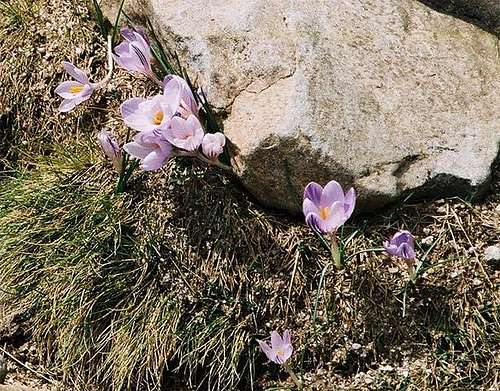 Crocusses on the Renoso Route in May
In 1971 the Parque Naturel de la Corse was established. It comprises 2500 square km, mainly in the centre of the island and Monte Renoso is part of it. The usual restrictions apply.
When To Climb
Monte Retondo can be climbed all year round. In winter the region was used as skiing region but the lifts don't run anymore. During that season, Monte Renoso is accessible by snowshoes or skis from Vizzavona. Don't count on the side roads to be cleared off snow.Accommodation
It's getting more and more easy to find accomodation on Corsica. However, most of the hotels or holiday apartments as well as campgrounds are located on the coasts. In the villages along RN 193 you'll find occasional inns and hostels and at Vizzavona there are still some big hotels which date back to the 1920s. Camping is only allowed near the huts and bergeries along the GR20 trekking trail and the rules are enforced by rangers.Weather Conditions
 Monte Renoso from Monte d'Oro
Weather quickly changes on Corsica, especially in the mountains and even more especially near the passes through which fierce winds blow almost every day. Quite often a perfect morning will turn into fog around noontime but settle to calm weather in the late afternoon. Temperatures on the mountains are often less tahn what you would expect when starting from the valleys or the coast.
Maps & Books
Maps
- Monte Renoso, Bastelica
1 : 25.000
Carte de Randonnée 4252 OT
EAN: 3282114252026
Books
There are quite naturally quite a number of guidebooks, most of them in French. I found the following as good as could be expected:
- Corsica (Corse / Korsika)
Klaus Wolfsperger
Rother Verlag
ISBN: 978-3-7633-4819-0 (English)
ISBN: 978-3-7633-4907-4 (French)
ISBN: 978-3-7633-4280-8 (German)