
|
|
Mountain/Rock |
|---|---|
|
|
39.30444°N / 119.67225°W |
|
|
Storey |
|
|
Hiking |
|
|
Spring, Fall, Winter |
|
|
7682 ft / 2341 m |
|
|
Overview
Mount Bullion is the third highest mountain in the Virginia Range in Northwest Nevada. It is easily accessed from Virginia City, Nevada, although it is hidden behind the higher Mount Davidson, which at 7864’ is the highest peak in the range.Mount Bullion is part of a long ridge that extends north-south, reaching its highest point just west of Virginia City. In fact, only about 2 miles and 1600’ of gain separate Mount Bullion from the Spanish Ravine trailhead in Virginia City. Mount Bullion can easily be hiked along with other named summits along the ridge, including Mount Davidson and Ophir Hill 7782’.
Mount Bullion has a prominence of approximately 300’ and it is clearly distinct from its neighbors. It has wonderful views of the Sierra Nevada to the west, as well as a myriad of peaks to the north and south.
The best time to hike up Mount Bullion is probably late fall (November, December). It can be hiked in late winter/early springtime (February, March, April), but this is usually the rainy season, so only go after a few days of dry weather. During the summer months, temperatures are far too high.
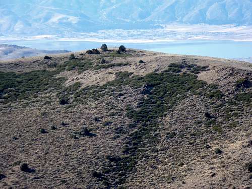 Mount Bullion seen from near Mt. Davidson's summit. Washoe Lake behind.
Getting There
From Reno, Nevada take 395 to exit 57B, or take exit 61 (Virginia Street) and drive south. Either way leads to Highway 341, the Geiger Grade. The Geiger Grade is a mountain pass road from Reno to Virginia City. It winds through the hills of the Virginia Range for about 15 miles after leaving Virginia Street in south Reno. Once in Virginia City, head through Main Street and then up Taylor Street. Taylor Street shortly becomes Stewart Street. After the name switch, turn left on Greg Street. Adjacent to an obvious parking area is a dirt road leading up the Spanish Ravine.Note that most of these streets are very poorly marked, so use Google Maps™. It is pretty easy to find, since pretty much any street on the right side of Main Street through town will lead up this way, and you are basically trying to hit the road below the “V” on the hillside above town.
Route Information
The primary route is the Spanish Ravine, which runs between Mount Davidson and Ophir Hill.From the parking area, follow the obvious road up the hill, following a series of telephone poles. The road cuts up very steeply aside the telephone poles early on in the hike. You can instead stay left and hike up the ravine. Either way will lead to the same place, which is the ridge top at about 7675’. Once on the ridge top, drop to the other side, where there are wonderful views of the Sierra Nevada to the West. The road continues to Mount Davidson. Mount Bullion is visible on the right. You can head back down the road away from Davidson to a fork, where the road descends towards Mount Bullion at a saddle about 300’ below the summit, or you can head straight downhill and walk through the brush down towards a dirt road on the north side of Mount Bullion. Then head straight up the north face hiking about 350’ to the top from the road below. This route saves about ½ mile.
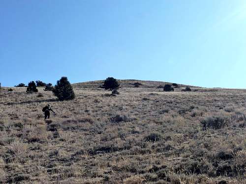 Heading up the north face of Bullion
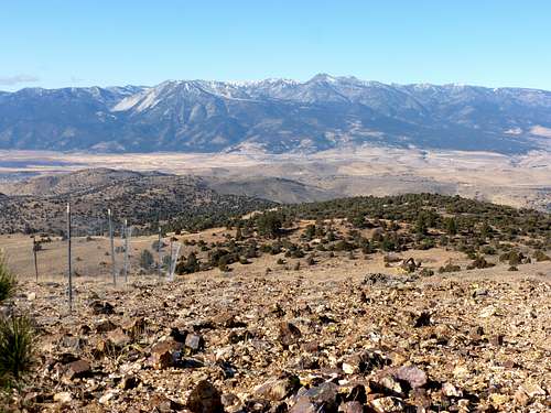 View west to the Sierra Nevada
 Mount Davidson 7864' from the summit of Mount Bullion
Mount Davidson can then be reached by heading back down the north face of Bullion, and then heading up a steep animal trail through the brush about 400’ up the to the ridge just below the summit in about 1/3rd of a mile.
If you hike both summits, this entails about 5-6 miles round trip, depending on which routes are taken. The total elevation gain will be over 2,100’.