
-
 21228 Hits
-
 90.81% Score
-
 33 Votes
|
|
Mountain/Rock |
|---|---|
|
|
50.57306°N / 115.15583°W |
|
|
Mountaineering, Trad Climbing |
|
|
Summer |
|
|
10413 ft / 3174 m |
|
|
Overview

Mount Foch
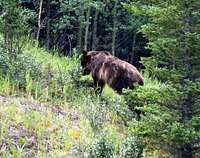
Mounts Sarrail and Foch create one of the more sensational Canadian Rockies intersections, only visible after gaining several thousand feet to the col below the northeast buttress (III, 5.10a) of Mount Sarrail above scenic Rawson Lake. During the summer alpine season, dying glacier ice falls off of the steep and massive rock walls on Mount Foch’s north face. What can make this outing even more spectacular, as evidenced by our trek up to the Northeast Buttress (III, 5.10a) in 2008, is the wildlife encounter opportunities. On our early morning approach we crossed paths with a female grizzly bear and multiple moose. We also witnessed one moose actually crossing (swimming) Rawson Lake and a bald eagle hunting the lake in the early morning hours. This portion of the trip is all part of the experience during the several thousand feet gain before you even suit up for the climb. Once you reach the col below the northeast buttress of Mount Sarrail, you come into full view of Mount Foch’s, yet to be climbed, impressive ice clad north face. This impressive steep wall is at that point of time where it is losing its glacier properties. There is not a consistent path of rock or solid ice to follow that is not seriously in harms way.
In 1986 Dougherty and Martin insisted on establishing a new route in the area. The prominent buttress of Mount Sarrail towering over Upper Kananaskis Lake no doubt became a prime candidate. This is the only established technical climbing route up the mountain, but one can also access Mount Sarrail’s summit and dying glacier via the northwest face by scrambling to the summit from the west side of the mountain. This of course is your descent for the northeast buttress route.
Mount Sarrail was named after some French commander from WW I and was first ascended by the scramble route in 1930 by Gardiner and Feuz. Mount Sarrail’s summit lies on the border of Kananaskis Provincial Park and Elk Lakes Provincial Park. Mount Indefatigable is situated directly to the north and Mount Joffre sits to the southwest.
Getting There
Kananaskis Lakes is a large camping and trail mecca located at the end of the Smith-Dorrien/Spray Lakes Trail (Hwy 742-gravel) south of Canmore, but is more readily accessed via the paved Kananaskis Trail (Hwy 40). In either case, once on the Kananaskis Lakes Trail (paved), drive to the Upper Kananaskis Lake parking trail head. Head around the south end of the lake on a well marked trail. This trail accesses the Mount Sarrail scramble from the Astor Lake trail or the Northeast Buttress via the Rawson Lake trail. Pay attention on your left to the marshy meadow for moose on the final section of this drive. You will also see them up at Rawson Lake.
Red Tape/Camping
There are no permit requirements to enter, climb and/or park in Kananaskis Country. This is active grizzly country however. Take bear spray during non-hibernation months. This is avalanche terrain during the winter. Therefore it would be prudent to check recent notices posted on the park’s website regarding that issue. The park headquarters is actually located on Highway 40 (Kananaskis Trail) several kilometers south of the Trans-Canada. Notices are posted outside if they are closed. This is a solid information center with good staff and beta and is open all year.
There are campsites galore in the Kananaskis Lakes complex, backcountry and camper sites. You cannot camp outside of the marked specific camping areas in Kananaskis. Refer to the Kananaskis Provincial Park website for more information regarding camping and/or lodging. Engadine Lodge obviously offers premium lodging for the area as well.
When to Climb
As with most climbs in the Canadian Rockies, the driest time is from June through September. The Northeast Buttress route up Mount Sarrail is a serious and remote climb that should only be attempted in the best of weather during prime alpine climbing season.
External Links
The Kananaskis Provincial Park website is a very thorough park website, including trail conditions or closures, wildlife notices, weather conditions, avalanche conditions, camping permits, whitewater conditions, etc. It is an excellent source if you are going to spend any time here and comparable to any National Park website I have used. Outside of the parks web site, Canadian Avalanche Association is also useful, particularly for winter travel.