
|
|
Mountain/Rock |
|---|---|
|
|
35.40940°N / 82.8564°W |
|
|
6030 ft / 1838 m |
|
|
Overview
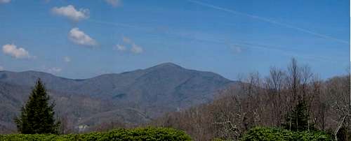
Cold Mountain from the Parkway
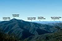
Cold Mountain is located in the Shining Rock Wilderness, a part of the Pisgah National Forest, approx. 20 miles south west of Asheville, North Carolina. Cold Mountain is centrally located in the mountains of southwestern North Carolina. Its close neighbors include the Smoky and Great Balsm Mountains to the west and the crown of the Appalachians, the Black Mountain Range and Mt. Mitchell to the North East. Even so, Cold Mountain remains largely undiscovered to most hikers who come to the area. There are only two possible routes to the summit and they are not short or well graded. This is why Cold Mountain remains largely unvisited in an area where roads and paved paths lead to many of the areas highest peaks. The summit is reached either from the south or the west via the Art Loeb Trail and Cold Mountain Trail.
The easiest, but longest, option is from the Black Balsam Area to the south. This is a 8.5 mile hike ONE WAY but the elevation gain/loss is minimal and there are many fine campsites along the way should you decide to stay overnight. The Art Loeb Trail heads north from a small pull off along the Black Balsam Knob Road about 1 mile from the Blue Ridge Parkway at an elevation of 5800 ft. The trail quickly ascends onto the bald, grassy ridge w/ 360 degree views and passes over Black Balsam Knob(6214 ft.) at 0.6 mi. and Tennant Mtn(6046 ft.) at 1.6 mi. before descending sharply back into the trees to Ivestor Gap after 2.4 mi. At Ivestor Gap there are multiple trail junctions. The Art Loeb Trail soon meets the Grassy Cove Trail which heads right at 2.8 mi. and continues to Shining Rock Gap at 4.2 mi. Here the trail con get confusing. Ahead you will see three trails heading right center and left. The Art Loeb Trail goes LEFT. Follow the trail over Stairs Mtn(5869 ft) and then on to Deep Gap at 7 mi. From here the Art Loeb Trail heads left and ahead its Cold Mountain Trail. Cold Mountain Trail ascends over 1000 feet in the 1.5 miles it takes to reach the summit. Backtrack or descend to alternate P.A. if you bring two vehicles by way of second route.

Art Loeb Trail
The second route is a little shorter (5.3 mi. ONE WAY) but much more strenuous. From the trailhead at Daniel Boone Boy Scout Camp the Art Loeb and Cold Mountain Trails ascend almost 3,000 feet to the summit. The Art Loeb Trail ascends from the parking area to the Cold Mountain Trail on the Left after 3.8 miles. Turn left on the Cold Mountain Trail for the final 1.5 mi and 1000 feet of vertical. This trail lacks the views of the first route but if you enjoy watching the flora along your hikes this trail gives you the ecological equivalent of a trip 1500 to the north in the 5.3 miles you hike to the summit.
The summit itself is tree covered and viewless but if you backtrack about 10 yds down the trail from the summit there is a small spur trail to the left that leads to a rock ledge with an incredible 180-degree view to the south.
Getting There
Black Balsam Knob Parking Area:

NC-215
From I-40 Westbound: Take Exit 53 and head south about a mile to the Blue Ridge Parkway. Head south on the Parkway about 40 miles to the Black Balsam Mountain access road on the right. Turn right and go about 1 mile to a small pull-off area on the right.
From I-40 Eastbound: Take Exit 31 and head south on NC-215 approx. 26 miles to the Blue Ridge Parkway. Head left (north) on the Parkway about 3 miles to the Black Balsam Knob access road on the left. Turn left and go about 1 mile to a small pull-off area on the right.
Camp Daniel Boone: *****Make sure to get permission from the camp director beore leaving your vehicle at the trailhead. *****
Take Exit 31 and head south on NC-215. Approx 4 miles past the stoplight in the town of Bethel turn left on Little East Fork Road and follow it to Camp Daniel Boone. The Parking Area is at the far side of the camp on the left.
Red Tape & Backcountry Camping
There are no fees to for hiking or camping in the Shining Rock Wilderness.
However, if you are planning to hike Cold Mountain during the winter months (Oct.-Apr.) you should call the info line below to check on Parkway Closures. The Blue Ridge Parkway is closed during periods of ice and snow. Your only access to the mountain would then be Camp Daniel Boone.
Blue Ridge Parkway Info: 828-298-0398
There are numerous backcountry campsites located along the Art Loeb and Cold Mountain Trails. There are no permits or fees to be obtained. Keep in mind though that inside Shining Rock Wilderness there a no fires permitted and groups are limited to 10 or less.
When To Climb
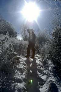
Winter Sun
Regardless of the season the summit should be virtually devoid of hikers. However, during the summer months (Apr.-Sept.) hiking traffic can be rather heavy in the Black Balsam Knob Area.
As this is a tree covered summit the best views are offered during the winter months after the leaves have fallen. The air quality is also much better during the cooler months as air pollution and humidity can cause views on even clear days to be reduced to less than 10 miles.
Take A Virtual Hike To Cold Mountain!!
Climb with me up Cold Mountain from Camp Daniel Boone via the Art Loeb and Cold Mountain Trails. A gorgeous albeit strenuous hike. ENJOY!!
Mountain Conditions
A Clear Day
You can view a live webcam of the mountain here or by visiting "LINKS" page.
Area info can be obtained from the following:
District Ranger
USDA Forest Service
Pisgah District
1001 Pisgah Highway
Pisgah Forest, NC 28768
704-877-3265
 |
External Links
- South Beyond 6000 Peak List
At 6030' Cold Mountain ranks number 39 out of the 40 peaks in the "South Beyond 6000" peak bagging list. - Live View of Cold Mountain
A live webcam view of Cold Mountain updated every 30 minutes or so. The cam is located off the Blue Ridge Parkway near Frying Pan Mountain at an elevation of about 4800 ft. Air quality index is also given.
DWhike's Adventures - Shameless self promotion...come visit my website for more pics of Max Patch and other places that I have wandered off to in recent years...