
|
|
Mountain/Rock |
|---|---|
|
|
40.67680°N / 111.144°W |
|
|
10605 ft / 3232 m |
|
|
Overview
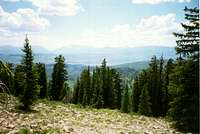
 Eastern slopes of Duke Mountain from Yellow Pine Lakes
Duke (elevation 10,605 feet) is the name of the benchmark on the USGS maps. Forest Service maps posted at the trailheads seem to prefer the name "Duke Mountain" for this summit, though the Division of Wildlife Resources labels the peak as "Flat Iron Mountain" on their maps. Take your pick. Either way, this peak is the second-western-most peak in the Uinta Mountains. Hoyt Peak is the only peak farther west in the chain.
Duke Mountain fails to even reach timberline, but the north side has a steep escarpment, and the views of the Wasatch Range and the Western Uintas are excellent. Not many hikers or climbers visit the summit.
The Uinta Mountains are one of the few mountain ranges in North America that run east to west rather than north to south. Within the Uinta Mountains are about 2000 lakes, and some 900-1000 are full of trout. Along with the San Juans in Colorado, the Uintas have more contiguous area above timberline than any other area in the Continental United States. This is a beautiful area with many lakes, meadows, wildflowers, and some rugged peaks.
Getting There
 Duke Mountain Ridge
Paulsin Basin Trailhead
The route to the trailhead begins in Marion on State Route 32. Marion is located half way between Oakley and Kamas. From the north end of Marion, locate "Upper Loop Road". This paved road heads east from two different entrances that are .5 miles apart. From the northeastern secction of the loops road, take the dirt road that heads east that is posted for "Piute Creek". This road heads east up Hoyt Canyon. Most of the spur roads are blocked by gates. There are two roads that climb to the head of Hoyt Canyon, but the one to the right is a bit less rough. This right fork also has a branch heading west to Marion. Take a left at this second junction and the road climbs to the head of Hoyt Canyon. When driven with care, and car can make it to the head of Hoyt Canyon, but the road is for 4wd vehicles beyond. From the head of Hoyt Canyon, stay on the main road all the way to Paulsin Basin. There are too many side tracks leaving this main road to describe. The main road is sometimes marked with signs stating "Forest Road #080". Once at the basin, take the right fork of the road and the track climbs to the west ridge of Duke Mountain. Make sure to have and use a good map when driving to the trailhead.
Yellow Pine Creek Trailhead
The trailhead is at a large signed parking lot that is located on the north side of Highway 150 6.5 miles east of Kamas. This trailhead is accessible year-round.
Upper Setting Trailhead
This trailhead is a little tricky to find. The route begins from the Upper Setting Road. This road is posted with a sign, and is located on the north side of the highway, 8.7 miles east of Kamas. The lower half of this un-paved road is suitable for passenger cars, but the upper half is suitable only to high clearance vehicles. This is the easiest way to find the trailhead: Follow the main road to it's end. There are many side tracks branching from the main road. Turn around at the end of the road, backtrack, and take the second 4wd track that branches from the north (right when backtracking) side of the main road. Drive (or walk) north along this track and take a left at a junction. This track heads west a short distance. Park at the vehicle barrier trench located next to a pond.
South Fork Weber River Trailhead
From Oakley, drive east up the Weber Canyon Road for 4.9 miles. Turn right at a junction. There is a gate here, but it is supposed to be un-locked. There are private property signs as well, but this is a public access road owned by the forest service and maintained with tax money, and is always open to the public. If the gate is locked (seasonal), you can walk through. Drive south up the South Fork Weber Canyon Road. Stay on the main road and follow signs labeled "South Fork". Do not park or camp on the road before the forest service boundary. There is a gate at the National Forest boundary. Beyond the gate, the road deteriorates into a 4wd road. The road will reach a stream crossing and use the stream as a roadbed for a while. Park here as the streambed is very rough and not worth the effort to drive.
Box Canyon Trailhead
From Oakley (State Route 32), head east along the Weber Canyon Road. After about 12 miles, turn south (right) on the Smith and Morehouse Road. Follow the good gravel road past the Smith and Morehouse Reservior. After another mile, turn right onto a road posted for Red Pine Creek. The Red Pine Creek Road deteriorates rapidly into a 4wd road. Follow the road for just over a mile and take a left at the junction. There are some very short spur tracks before this junction, so you may have to back-track short distances to find the correct road. Turn left at the junction and follow the road past a sign for the "Yellow Pine Trail". Continue on the rough road to its end. This is about 1.5 miles from the junction.
Routes Overview
 Wasatch Range viewed from Duke Mountain
Paulsin Basin Route
This is the shortest and easiest route to hike, but has the hardest trailhead to drive to. You will either walk or drive the extremely steep 4wd road to the ridgetop. From the ridgetop, you will follow the ridge south and then east to the summit. There is no trail, but the hiking isn't too difficult.
Yellow Pine Creek Route
This route has the most accessible trailhead. The route heads up the Yellow Pine Creek Trail to the saddle between the Box Canyon and Yellow Pine Creek drainages. From the saddle, the route follows the ridge west to the summit (no trail).
Upper Setting Route
This is one of the shorter routes, but the road is rough to the trailhead. The route follows the trail to Castle Lake, then NW to the Box Canyon-Yellow Pine Creek saddle. The route then follows the ridge west to the summit.
South Fork Weber River Route
This is a very scenic and solitary route. The bad news is that the drainage is somewhat thrashed by cattle. This is also the longest of the routes described. The route heads up the South Fork Weber River Drainage until the trail fades out. The route continues cross-country up the drainage to the basin north of Duke Mountain. From there, the route heads southeast and reaches the ridge just west of the summit.
Box Canyon Route
This is a beautiful route. Although maps show a trail up Box Canyon, it is totally faded away, and route-finding is required. This is a very scenic and seldom visited drainage. This cross country route heads south to the saddle between the Yellow Pine Creek and Box Canyon Drainages, and then follows the ridge west to the summit of Duke Mountain.
Guidebook
More details about the area can be found in the book Western Uinta Backcountry Guide, including many routes to the summit, and hiking trails to the many lakes, and fishing information. Just send me a PM if you want to purchase the book.SP members can have the book for 1/2 price, and there is no shipping cost.
 Guidebook
Red Tape
For the Yellow Pine and Upper Setting routes, and for traveling Highway 150, there is now a $3 per day use fee for parking along the highway. There is no red tape for the other routes.When To Climb
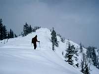 East Ridge of Duke in winter.
The normal summer hiking season is from late June until sometime in October. Late September-early October is beautiful with the fall colors.
The Paulsin Basin Road, Upper Setting Road, South Fork Weber River Road, and the Box Canyon Road are all open only during the above season, but you can ski or snow-shoe along the roads.
Highway 150 is open year-round to the Yellow Pine Trailhead, making winter access relatively easy from that route.
Camping
There are many campgrounds along Highway 150, but they can be crowded during summer weekends, especially around holidays.Paulsin Basin Route
There are many good campsites along the road in upper Paulsin Basin.
Yellow Pine Creek Route
There are also many backcountry campsites on the Yellow Pine Trail.
Upper Setting Route
There are many informal campsites along the Upper Setting Road. There are good campsites in the meadows to the north and south of Castle Lake. In winter, there are now several maintained yurts on the Upper Setting Road and around Castle Lake. Contact the ranger district for information.
South Fork Weber River Route
There are good campsites along the South Fork Weber River Road once you reach the forest boundary. There are also good backcountry campsites along the upper part of the route and in the basin north of Duke Mountain, but the area seems to be heavily grazed by cattle. Treat your water well.
Box Canyon Route
The upper and lower sections of the route have excellent and secluded campsite. The middle section of the route has only a few small and scattered campsites.
Mountain Conditions
 Cornices on Duke Mountain
Contact the ranger station in Kamas for current road and trail conditions. Their phone number is 801-783-4338.
WEATHER FORECAST FOR WESTERN UINTA MOUNTAINS
Here are some average highs and lows from Mirror Lake at 10,190 feet :
| MONTH | HIGH | LOW |
| JAN | 23 | 0 |
| FEB | 25 | 2 |
| MAR | 29 | 6 |
| APR | 38 | 14 |
| MAY | 47 | 22 |
| JUN | 57 | 31 |
| JUL | 67 | 38 |
| AUG | 65 | 37 |
| SEP | 57 | 30 |
| OCT | 46 | 19 |
| NOV | 32 | 10 |
| DEC | 26 | 4 |