
-
 13207 Hits
-
 88.19% Score
-
 26 Votes
|
|
Mountain/Rock |
|---|---|
|
|
40.39480°N / 111.62247°W |
|
|
Utah |
|
|
Hiking, Skiing |
|
|
Spring, Summer, Fall, Winter |
|
|
10791 ft / 3289 m |
|
|
Overview
The summit of East Peak is a fun and interesting peak on the most eastern flank of the Mt. Timpanogos Massif. This peak is less well known than other prominent peaks in the vicinity, however once reaching the top the views to the west provide a unique angle of the east aspect of Timpanogos, down into Hidden Lakes Cirque, and a portion of the upper Primrose Cirque area. Views also from the top look down to the east over the Heber Valley area, and on a clear day the 13,000 foot peaks of the Uinta Mountain Range are seen. East Peak was named by the popular local guidebook author Michael Kelsey, who has written a book dedicated completely to Mt. Timpanogos. See the additional information section for this book. One point of interest has been made about this summit by SP member Scott, is the original name for the summit being Elk Point. The USGS Quad map, as seen in the route section shows the reference to Elk Point though the type on the map is a good distance away from the summit location.East Peak dominates much of the view while heading up or down the popular Aspen Grove Trail, one of the two primary trails which lead to the upper reaches of Mt. Timpanogos. While the summit of East Peak may not be the main objective of most making their way up the mountain, it provides solitude from the crowds for those seeking a great part of Mt. Timpanogos during the summer season when hundreds of people are on the mountain. If you are wanting to break away from the hustle and bustle this peak is definitely worth a visit. It also can be a great warm up prior to starting the rugged Razorback Ridge, a class 4 scramble which leads from East Peak's south saddle over incredible terrain to the Second/South Summit of Timp, the second highest peak on the mountain at 11,722 feet.
 East Peak from Primrose Cirque, photo by MountainGazelle.
 JDrake's great photo of the west side of East Peak, sunrise to boot.
 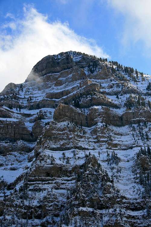 East Peak's north west face, as seen from upper Primrose Cirque.
  East Peak seen from Hidden Lakes Cirque.
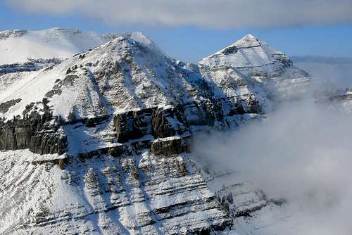 Looking west at Robert's Horn, and North Timpanogos from the summit.
 Breaking clouds gave this view of North Timp, from the summit.
Getting There
Access to East Peak is from the Aspen Grove Trailhead area. SP member Dean has written excellent directions to Aspen Grove, which have been copied from his main page on Timp below. Access to the Aspen Grove Trail is open year round, weather permitting.You can access Mt. Timpanogos easily from Highway I-15, using the 272 exit and driving east along highway 52 ( 800 North in Orem) to the junction with highway 189, the Provo Canyon road. Go East on 189 for 7 miles to the Sundance Ski resort turnoff (watch for it just after you go through a tunnel) and turn left on highway 92 for 6 miles, going past the Sundance ski area and the Aspen Grove recreation area. Proceed until you come to a fee booth (pay the fee ) and look for parking just beyond in a lot at the left. If full, look for additional parking just up the road. From the parking lot, you'll find the most popular trail, the Aspen Grove trail that heads on up the mountain.
See the red tape section for fee's involved using this trail/area.
Red Tape
The Aspen Grove campground/trail charges a use fee of $6.00 for a minimal 3 day use pass. Pay these fees at the trail head locations through out the canyon in envelopes and drop boxes provided.There is a 15 person group size limitation.
Campfires are not permitted on the mountain, and camping must be 200 feet from lakes or streams.
Leashed dogs are permitted on the trails on Mt. Timpanogos, good news for you dog owners.
The Aspen Grove area is the south east access to the popular Alpine Loop Scenic byway. One thing to note about the upper reaches of American Fork Canyon, Sundance, and the Alpine Loop area is to use caution as the road is very narrow, some vehicles traveling at higher speeds around these corners and switchbacks make a risk for others on the road. Drive defensively on this one and use your own discretion if venturing above and beyond the Aspen Grove area.
Access to the Alpine Scenic Loop is closed for winter usually during late October through mid May. Check for current road closure information on the Utah Department of Transportation link here.
Camping
Developed camping.In the Aspen Grove area is the Mt. Timpanogos Campground, which offers developed camping sites, water and latrines. The Aspen Grove Trailhead is a short walk from a lot of the camping areas at this location. This campground is very popular, book a reservation well ahead of time.
Description: Elevation 6800 feet. 27 campsites.
Address: Pleasant Grove Ranger District
Uinta National Forest
390 North 100 East
Pleasant Grove, UT 84062 Phone: 801-785-3563
Season: May - October
Fee: $11/ night; $3 entrance fee
Reservations: tel: 1-877-444-6777
More information on this location can be seen here.
Back country camping.
There are many back country campsites on Mt. Timpanogos, which usually follow the 200 foot rule from any lake or stream though tents have been seen perched on the small center portion of Emerald Lake. There are several areas located in the vicinity of Hidden Lakes Cirque, which can be reached by a short off trail walk.
When to climb and gear.
This peak can be climbed year round.Winter and Spring:
Probably the foremost danger on the Aspen Grove Trail is upper portion of Primrose Cirque, which falls victim to avalanches during the winter months. Use discretion when in the back country during the winter season in this area. The Utah Avalanche Center is a great resource for checking on the current snow conditions of the Wasatch. While venturing onto the higher portion of the mountain during the winter season, an ice axe and crampons are highly recommended. Avy gear is highly recommended. Another topic worth mentioning is the "Killer Snow Holes," that form at the smaller waterfall areas on the Aspen Grove Trail during May and June as the water flows beneath the snow pack. This phenomenon has taken lives in the past, the Forest Service now has a regular practice of posting signs at these locations, even blowing them up if conditions warrant doing so.
Summer and Fall:
This is by far the most popular time for hiking and exploring on Timpanogos. Early summer from late May and early June will still have the possibility of needing an axe and crampons handy, fine consolidated snow awaits on the upper reaches of the mountain. Compacted snow can linger well into the summer months depending on the previous winter snow pack. In mid to late summer a good sturdy set of boots and trekking poles will come in handy. Also at this time be prepared for the insects that always come out of the woodwork. The fall season is probably the most scenic time on the mountain, though temperatures can be brisk later on, a good soft shell jacket is essential.
Route information.
The route to East Peak will be compiled into this section, all distances and elevation will be based from the start of the Aspen Grove Trail. From the Hidden Lakes Cirque area there are no improvised or maintained trails to the summit of east peak.South Ridge approach, via Hidden Lakes Cirque. Class 2, .7 miles, 920 vertical feet.
Most of the elevation gained to the peak will be done on the Aspen Grove trail, to the base of Hidden Lakes Cirque with roughly 3,000 feet. The route to East Peak begins at the north west portion of the cirque area, heading south east off trail towards the pass on the ridge above, at 10,260 feet. Make your way up the scree slopes or to the right by the trees to the pass. From the pass head up the ridge to the summit, some minor scrambling will be involved. This route is pretty straight forward, and excellent views are available along the way.
Another alternative route to East Peak is to cut directly across the Cirque to the western base of the peak, and head up the brushy talus laden hill side. Some dwarf pines will be encountered about half way up. During summer months a good set of trekking poles can be useful if following this approach.
Mountain weather.
Mt. Timpanogos is one to check on with the weather before venturing out. The closest locations to the area discussed are Sundance Ski Resort, and the town of Alpine to the west. Two links for weather location are included below:Alpine, Utah weather link.
Sundance Resort, Utah weather link.

Additional information, further reading.
Additional information, further reading.An excellent resource for Mt. Timpanogos is Michael R. Kelsey's book, Climbing and Exploring Utah's Mt. Timpanogos.