
|
|
Mountain/Rock |
|---|---|
|
|
40.39134°N / 111.63736°W |
|
|
Utah |
|
|
Hiking, Scrambling, Skiing |
|
|
Spring, Summer, Fall, Winter |
|
|
11161 ft / 3402 m |
|
|
Overview
The Shoulder is one of several 11,000 foot sub-peaks on the Mt. Timpanogos massif. This summit is not visited by many, though Emerald Lake, one of the most popular destinations on Timpanogos is less than a fourth of a mile as the crow flies. The Shoulder rises nearly 800 vertical feet directly above Emerald Lake to the south east. Even with such close proximity to the lake and the main summit, the routes leading to the summit of the Shoulder area rugged off trail climbs which will turn away many uncomfortable with exposure and lacking a passion for off-piste route finding.Views from this summit are probably some of the best for the surrounding terrain on Mt. Timpanogos due to it's centralized location on the mountain. Directly west is the large east face of the main summit at 11,749 feet. South is the Second Summit, the second highest summit on Timp. North is Robert's Horn, a unique sub-peak which looms over much of the Aspen Grove approach on Timp. To the east is Hidden Lakes Cirque and East Peak, another very prominent summit which dominates the south side of Aspen Grove. Any direction seen from this summit is simply outstanding.
Another very exciting prospect about this peak is the main route in which is used to reach it. The Razorback Ridge/Terrace traverse, as explained by SP member Scott, is probably one of the most interesting and more challenging routes on Mt. Timpanogos. This route could explain why so few people have reached the summit of the Shoulder area, due to the large amounts of exposure the Razorback traverse has. More on the Razorback section below.
 Bob Sihler's fine shot of the Shoulder near Emerald Lake.
 Emerald Lake, with the Shoulder looming overhead.
 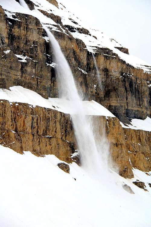 A wet slab avalanche off of Timp's east face, May 2010. Seen from the glacier area.
 A mid-November 2009 view of the Razorback Ridge from the summit of East Peak.
 Fossils found in the gray limestone near Forgotten Peak.
 Utah Geologic relief map.
[img:638524:alignleft:medium:At the summit area checking out the South/Second Summit, and the Timp Glacier. ]
Getting There
Two access points can be used for the Shoulder, the Timponeke Trail on the north side of the mountain, and Aspen Grove on the east. Aspen Grove offers the shortest access of these two points. Both of these sections have already been written by Dean, he has written them in excellent fashion, the info is copied from his pages. One other thing to note is that the Alpine Loop Scenic Byway, which is used for the Timponeke approach mainly, is a very narrow winding road on the north and east side of Timp. Some drivers on this road don't exercise the same discretion while on the road as some of us, use caution on this road and keep your eyes peeled, especially around the corners.The Alpine Scenic Loop is usually closed from October through May during the winter season. Check for current road closure information on the Utah Department of Transportation link here.
Timponeke Trail access.
From I-15 take the 284 exit(no longer the 287 exit as shown on some maps so be aware of this change) and go east on highway 92. Also note that it mentions Alpine and Cedar Hills and if you see this, you've got the correct exit. Go 8 miles until you enter the American Fork Canyon and you'll be confronted by a fee booth. Continue on another 8.2 miles (passing the Timpanogos Cave national monument area) until you come to the Timpooneke Campground on the right side of the road. The trailhead to the Timpooneke route is just beyond the campground area.
Aspen Grove access.
You can access Mt. Timpanogos easily from Highway I-15, using the 272 exit. and driving east along highway 52 ( 800 North in Orem) to the junction with highway 189, the Provo Canyon road. Be aware that there is road construction going on in Provo canyon but that now seems to be further up Provo Canyon. Go East on 189 for 7 miles to the Sundance Ski resort turnoff (watch for it just after you go through a tunnel) and turn left on highway 92 for 6 miles, going past the Sundance ski area and the Aspen Grove recreation area. Proceed until you come to a fee booth (pay the fee ) and look for parking just beyond in a lot at the left. If full, look for additional parking just up the road. From the parking lot, you'll find the most popular trail, the Aspen Grove trail that heads on up the mountain.
Red Tape
American Fork Canyon and Aspen Grove charges a use fee of $6.00 for a minimal 3 day use pass. Pay these fees at the trail head locations through out the canyon in envelopes and drop boxes provided.There is a 15 person group size limitation.
Campfires are not permitted on the mountain, and camping must be 200 feet from lakes or streams.
Leashed dogs are permitted on the trails on Mt. Timpanogos, good news for you dog owners.
Camping
Developed Camping.Timponeke Campground.
The Timponeke Campground is located just below the trail head area. Reserve this one well in advance as it is booked full for most of the summer season. Fee's are charged, water and latrines are available.
More info on this campground:
Location: From Pleasant Grove go 13 miles northeast on UT 92 and Forest Road 114.
Address: Pleasant Grove Ranger District
Uinta National Forest
390 North 100 East
Pleasant Grove, UT
Phone: 801-342-5240
Season: May - October
Fee: $11/ single; $22/ double; $3/ entrance
Reservations: tel: 1-877-444-6777
Mt. Timpanogos Campground.
In the Aspen Grove area is the Mt. Timpanogos Campground, which offers developed camping sites, water and latrines. The Aspen Grove Trailhead is a short walk from a lot of the camping areas at this location. This campground is very popular, book a reservation well ahead of time.
Description: Elevation 6800 feet. 27 campsites.
Address: Pleasant Grove Ranger District
Uinta National Forest
390 North 100 East
Pleasant Grove, UT 84062 Phone: 801-785-3563
Season: May - October
Fee: $11/ night; $3 entrance fee
Reservations: tel: 1-877-444-6777
More information on this location can be seen here.
Back country camping.
There are many back country campsites on Mt. Timpanogos, which usually follow the 200 foot rule from any lake or stream though tents have been seen perched on the small center portion of Emerald Lake. There are several areas located in the vicinity of Hidden Lakes Cirque, which can be reached by a short off trail walk. Other sites are abundant along the Timponeke trail as well.
When to climb and gear.
This peak can be climbed year round.Winter and Spring:
Access from the Timponeke Trail is much not used commonly as the access to the trail head is closed. Otherwise, probably the foremost danger on the Aspen Grove Trail is upper portion of Primrose Cirque, which falls victim to avalanches during the winter months. Use discretion when in the back country during the winter season in this area. The Utah Avalanche Center is a great resource for checking on the current snow conditions of the Wasatch. While venturing onto the higher portion of the mountain during the winter season, an ice axe and crampons are highly recommended. Avy gear is highly recommended. Another topic worth mentioning is the "Killer Snow Holes," that form at the smaller waterfall areas on the Aspen Grove Trail during May and June as the water flows beneath the snow pack. This phenomenon has taken lives in the past, the Forest Service now has a regular practice of posting signs at these locations, even blowing them up if conditions warrant doing so.
If heading up during the snow season, please check out the Utah Avalanche Center link here for the most current snow conditions on the mountain before venturing out.
[img:622940:alignleft:medium:A wet slab avalanche off of Timp's east face, May 2010. Seen from the glacier area.]
Summer and Fall:
This is by far the most popular time for hiking and exploring on Timpanogos. Early summer from late May and early June will still have the possibility of needing an axe and crampons handy, fine consolidated snow awaits on the upper reaches of the mountain. Compacted snow can linger well into the summer months depending on the previous winter snow pack. In mid to late summer a good sturdy set of boots and trekking poles will come in handy. Also at this time be prepared for the insects that always come out of the woodwork. The fall season is probably the most scenic time on the mountain, though temperatures can be brisk later on, a good soft shell jacket is essential.
Route information.
As mentioned above half the fun is getting there! The primary route to the summit of the Shoulder is from the Razorback Ridge and Terrace. Click here or check the attached route page on the Razorback route for more information. Scott did an exceptional job on this route page. Seen below are some images capturing just how fun this route is.[img:638516:alignleft:medium:West along the Razorback Ridge. The terrace portion of the traverse is in the gray limestone layer above the cliff area.]
[img:638515:alignleft:medium:Looking at the col and the eastern portion of the Razorback Ridge.]
[img:638519:alignleft:medium:From the end of the ridge looking at the terrace traverse, the Shoulder at the right.]
[img:638520:alignleft:medium:Looking east at the terrain halfway through the terrace traverse.]
[img:573291:alignleft:medium:A mid-November 2009 view of the Razorback Ridge from the summit of East Peak.]
------------------------------------------------------------------------
For those wanting to reach the summit of the Shoulder without the exposure of the Razorback Ridge, a second route exists up the Timpanogos Glacier from Emerald Lake. This route is primarily class II and requires basic route finding skills.
Glacier and the South/Second Summit route.
Class II
1.4 Miles, one way.
1,432 feet elevation gain.
From the Emerald Lake area begin heading up the glacier to the saddle between the South/Second Summit and the main summit ridge of Timp. Once reaching the saddle area, make your way up very loose talus and scree to the South Summit at 11,722 feet. From the south summit head north along moderate ridge terrain for several hundred yards. Beyond this point the ridge does get a bit exposed dropping into Cascade Cirque on the east. Stay left (west) to avoid this portion if you are uncomfortable with this section. After several hundred yards, the ridge mellows out and begins to descend to the north in the general direction of the Shoulder below. Plan on some loose talus and scree while heading down this portion, some of the larger rocks offer better support though some will shift under your feet. Once reaching the saddle area, the Shoulder is an easy walk up about 100 vertical feet to the south. A small climber's cairn marks the top.
[img:642560:alignleft:medium:Basic topographic route for access to the Shoulder from the Emerald Lake. ]
Geology.
Mt. Timpanogos' entire upper bulk is made of the Oquirrh Formation, which is a layered strata of limestone, mainly gray and light tan, with thin beds of quartzite. The age of the formation dates back to 270 to 325 million years old. In the gray colored limestone beds on the mountain fossils can be found, some places with more abundant deposits than others. Keep your eyes peeled for these as they are in different locations along the mountain.[img:535503:alignleft:medium:Fossils found in the gray limestone near Forgotten Peak.]
[img:543628:alignleft:medium:Utah Geologic relief map.]
Mountain weather.
Mt. Timpanogos is one to check on with the weather before venturing out. The closest locations to the area discussed are Sundance Ski Resort, and the town of Alpine to the west. Two links for weather location are included below:Alpine, Utah weather link.
Sundance Resort, Utah weather link.
