
-
 18805 Hits
-
 86.37% Score
-
 22 Votes
|
|
Mountain/Rock |
|---|---|
|
|
40.24270°N / 9.43160°E |
|
|
4799 ft / 1463 m |
|
|
Overview
 Monte Corrasi seen from Punta sos Nidos
 |  | 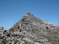 |
Supramonte is a karst high plateau composed of white limestone which drops vertically on its northern and western sides. To the north there are Bruncu Nieddu, Punta Cusidore, Punta sos Nidos and Punta Ortu Camminu, to the west Punta Carabidda and Monte Corrasi. A little further south Punta sa Pruna and Punta de sos Curoz form a smaller side ridge with less impressive faces.
 | 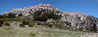 |  |
In contrast to the other Supramonte summits Monte Corrasi is not a climbing destination. Though quite impressive, when viewed from its western side the rock is rather fragile. This resulted in a lot of towers and spires being formed by time in front of the west face, again offering great and dramatic views from the top towards the plains below. Being part of Supramonte Monte Corrasi is covered by the same myriads of flowers though its somewhat higher elevation and high winds leave the summit pretty barren. In sheltered gullies below the summit you can find bushes of wild peonies and rosemary together with the abundant St. Pankratius Lillies and Cyclamen.
360° Summit Panorama
  |
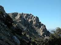
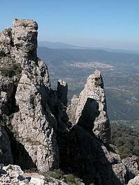
The Western Face: Towers and Spires
On its western side Monte Corrasi drops some 500m into the valley below. These drops are not vertical, however, erosion has formed quite a number of bizzarre structures. Some of these spires resemble structures you can find in the Dolomites.
 |  |  |
Getting There
 Saddle view towards Oliena during the descent from Monte Corrasi
Sardinia can be reached either by plane or by ferry. The main ports are Porto Torres and Olbia in the north and Arbatax and Cagliari in the south. Airports are at Alghero and Olbia in the north as well as (again) Arbatax and Cagliari in the south. For exploring the north eastern part of the island where most of the mountains are the best entry point is Olbia, which is where most flights go anyway.
Approaching the mountain from Olbia airport
Get on motorway SS 131 south in the direction of Siniscola / Nuoro. At the exit Lula / Dorgali get off and turn on SP38 south (again direction Dorgali). Shortly before you reach the town turn right on SP46, direction Oliena. In Oliena follow the signs to Monte Maccione, which - if I understand correctly - is the larger mountain of which Punta Carabidda and Punta Ortu Camminu are a part of. The road leads to a restaurant at which you can park your car.
Red Tape
 |  |  |
Monte Corrasi - like all other Supramonte summits - is part of the natural park Gennargentu / Golfo di Orisei. The usual restrictions concerning wildlife apply here and camping is strictly forbidden. The proprietor of the Monte Maccione Restaurant will let you camp in the restaurant garden however.
When To Climb
Monte Corrasi can be climbed all year round. The elevation of 1463m ensures that there will be no snow in winter. Autumn and spring are the best seasons for visiting Supramonte, summer being too hot.
Camping
Accommodation...
...is rather easy to find. Since all the interesting mountainous regions are on the north and east coast - which is where the largest beaches are - you can book hotel rooms and apartments from any tourist office. The region around the towns of Siniscola, Dorgali and Orisei should be the best staying places since they are rather central to most of the interesting locations. If you prefer climbing on the coast, head for Cala Golone.
Camping...
... is also easy to find in the vicinity of the beaches. Look for locations, using www.sardegna.com. Free camping in the natural park is not allowed. At the base of Monte Maccione above Oliena there is the restaurant "Monte Maccione" in the garden of which you can place your tents after asking the proprietor.
Weather Conditions
Go for the following link, which is in Italian but with ALL the information you might want to have on weather on the island:
www.sar.sardegna.it.
Head for "Bollettino dettagliato" link.
Maps 'n' Books
As for Maps I used only a road map scale 1:200000 since the guidebook I used has maps and is really quite good. Don't be fooled by the durations they state, you'll be much faster but the "getting there's" and "route description's" are very good.
The book is:
Sardinia (Sardegna / Sardinien)
M. Omidvar
Rother Verlag
ISBN: 3-7633-4800-X (English)
ISBN: 3-7633-4143-9 (Italian)
ISBN: 3-7633-4023-8 (German)