
-
 4888 Hits
-
 84.82% Score
-
 19 Votes
|
|
Mountain/Rock |
|---|---|
|
|
37.81883°N / 119.48405°W |
|
|
Mariposa |
|
|
Hiking, Scrambling |
|
|
Spring, Summer, Fall |
|
|
8880 ft / 2707 m |
|
|
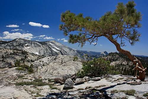
Overview
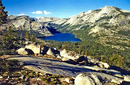
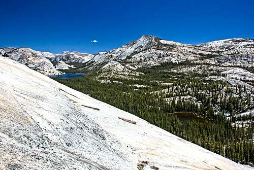
Tenaya Lake area from Olmstead Peak
Inspiration Point at the west end of Yosemite Valley has the classic view of all the great granite icons lined up down through the depth.
Glacier Point with it's spectacular vista of Half Dome and the awesome convergence of Yosemite Valley, Tenaya Canyon and Little Yosemite Valley carved by massive glaciers.
Then in the high country there is Olmstead Point. Probably many of those driving on Hwy 120 are spontaneously drawn to pull over here without even being aware of it simply because of the large crowded roadside parking lot and the mind blowing view.
Yosemites 2 biggest granite faces, Clouds Rest and Half Dome rise imposingly out over Tenaya Canyon in their breathtaking grandeur.
Across the road are prime examples of the marble top smooth slopes polished by glaciers where those a little adventurous can run up and explore the rock as well as the expanding view. If you have the time and the family isn't yelling to get back in the car because you're supposed to have lunch in Curry Village in an hour you can top out on "Olmstead Peak" (unnamed on topo). This is a short class 1-2 scramble up over a few benches to a significantly more expanded view of the high country.
This hike is 1 1/2 mile round trip with about a 500 ft gain.![Northern Sierra crest from Olmstead Peak]()
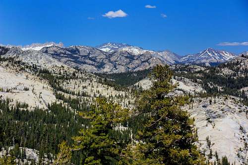
Sierra crest from Olmstead PeakFrom the west: From the entrance station to Yosemite on Hwy. 120 go 5 miles and turn left at the junction to the high country. Drive another 30 miles to Olmstead Point parking lot on the right.
From the east: From Tioga Pass entrance station go 18 miles on Hwy 120 to Olmstead Point.![Above Olmstead Point]()
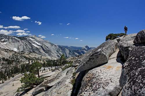
Hiking along the ridge from Olmstead PeakFrom Olmstead Point parking lot: Just cross the road and start hiking up the slope going off to the right as it ascends. A few easy benches are encountered along the way.![The Hoffman Range from Olmstead Peak]()
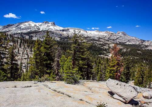
Hoffman Range from Olmstead PeakThere is a 20 dollar entrance fee per vehicle good for 7 days into Yosemite National Park.
This is a day hike.
For camping permits in Yosemite National Park contact: Call Yosemite National Park 209 372-0200.![South from above Olmstead Point]()
Cloud Rest from Olmstead PeakUsually late May to mid October depending on the snowfall. Or basically whenever highway 120 is open to traffic.![Smooth View]()
Smooth surfaces on Olstead PeakTENAYA LAKE: 8,160', At the southwest end of the Lake, next to Hwy. 120, 31 miles from the Hwy. 120 junction to Tioga Pass from the west.
PORCUPINE FLAT: 8,100', Next to Hwy. 120, 23.3 miles from the junction to Tioga Pass from the west.
WHITE WOLF: 7,875, 14 miles from the junction to Tioga Pass from the west on Hwy. 120, then turn left (north) 1 mile to the campground.
TUOLUMNE MEADOWS: 8,700', 7.5 miles west on Hwy. 120 from Tioga Pass from the east on the south side of the road.
Getting There
Sierra crest from Olmstead Peak
From the east: From Tioga Pass entrance station go 18 miles on Hwy 120 to Olmstead Point.
Route
Hiking along the ridge from Olmstead Peak
Red Tape
Hoffman Range from Olmstead Peak
This is a day hike.
For camping permits in Yosemite National Park contact: Call Yosemite National Park 209 372-0200.
When to Climb
Cloud Rest from Olmstead Peak
Camping
Smooth surfaces on Olstead Peak
PORCUPINE FLAT: 8,100', Next to Hwy. 120, 23.3 miles from the junction to Tioga Pass from the west.
WHITE WOLF: 7,875, 14 miles from the junction to Tioga Pass from the west on Hwy. 120, then turn left (north) 1 mile to the campground.
TUOLUMNE MEADOWS: 8,700', 7.5 miles west on Hwy. 120 from Tioga Pass from the east on the south side of the road.