
|
|
Mountain/Rock |
|---|---|
|
|
38.06580°N / 119.3569°W |
|
|
12001 ft / 3658 m |
|
|
Overview
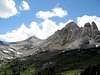
Virginia Peak is located in northeastern Yosemite National Park, on a prominent north-south ridge that splits off the main sierra crest at Twin Peaks. Viewed from the east near Virginia Pass, the peak looks very dark and forbidding, as it is composed not of typical Yosemite granite, but of the reddish metamorphic rock more characteristic of peaks like Mt. Dana and Dunderberg Peak. Seen in winter from the Virginia Lakes/Dunderberg area, the peak looks like a giant ice cream cone -- a perfect pyramid with almost equally spaced chutes of brilliant white snow draping down the sides.
 |  |  |  |  |
Getting There
Virginia Peak is usually approached from either Twin Lakes (via Horse Creek Pass) or from the Green Creek trailhead (via Virginia Pass). For an overview of the Horse Creek approach, consult the Matterhorn Peak page, with has a detailed description and photos.
The Virginia Pass approach deserves some description here. Take US395 to the Green Creek road. This road is about 4 miles south of Bridgeport, and about 5 miles north of Conway Summit. Turn onto the Green Creek road heading east. It is an 8 mile dirt road that takes you right to the campground and trailhead. There is one righthand turn you need to make at Dunderberg Meadow Road, but it is well signed. There is no official camping at the trailhead, but bandit camping abounds. There is an "official" USFS campground about 1/2 mile up the road.
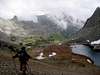
From the trailhead, follow the well graded Green Creek trail to Green Lake (2 miles). Just before the lake, you will reach a trail junction. The sign points right to "West Lake" and left to "East Lake" and "Green Lake". If you want to get up to Virginia Pass, do NOT take the trail to Green Lake. Instead, follow the right hand fork towards West Lake. The trail will contour above the north shore of Green Lake for about 1/4 mile, until it hits another junction, where the West Lake trail continues uphill, and an unmarked (but easily seen) use trail branches left and down towards the NW shore of Green Lake. This is the Virginia Pass use trail that leads up pretty Glines Canyon to the pass. Despite not being on most maps, this trail is very well worn and easy to follow. If you lose the trail, just backtrack a little bit and look for it. Remember, keep Green Creek between 25 and 75 yards on your left and you will find the trail.
There are two potentially easy spots to lose the trail that I will discuss here. First, above Green Lake, you will reach a spot where a tributary stream comes down the hill from the Par Value Lakes. The trail kind of dies out here near some old abandoned mining equipment. If you cross the tributary stream right where the trail dies out, you will soon see the trail pick up on the other side of the stream. This crossing can be difficult in early season and you may get wet.
The second spot is just above the stream crossing, where the trail comes upon an old abandoned miner's cabin. Heavy foot traffic in this area makes it confusing to find the correct trail. Don't follow the trail heading behind the cabin. Instead pass by the cabin, keeping it on your right, and drop down towards Green Creek. You should see the trail immediately as you drop down.
From there, the path up to Virginia Pass is easy to follow (5 miles from the trailhead). The pass is not difficult, and tops out at 10,550' with amazing views of Shepherd Crest, Sheep Peak and Cathedral Peak way down in Tuolumne Meadows. At Virginia Pass, the peak will be directly in front of you, across Virginia Canyon.
Virginia Peak can also be accessed from Tuolumne Meadows by hiking up Cold Canyon to Glen Aulin, then angling into Virginia Canyon and climbing up it to its head.
Red Tape
Virginia Peak is in Yosemite National Park, where backcountry permits are required for overnight camping. See the Tuolumne Meadows page for information on wilderness permits and quotas. If you are doing an overnight hike in from Twin Lakes or Green Creek, you will need to obtain a wilderness permit from the Toyiabe National Forest, which has its office 1 mile south of Bridgeport on US 395.
No permits are required for dayhikes.
When To Climb
Usually mid-summer through the fall is the best time. A winter ascent is most feasibly done from Twin Lakes, since all other nearby roads (Green Creek, Virginia Lakes, Tioga Pass) are closed in winter. In spring, Virginia Peak lies along the Tioga-Twin Lakes ski tour.
 |
Camping
See the red tape section above for information on camping in Yosemite and Hoover Wilderness.
mrchad9 - Oct 27, 2009 6:09 pm - Voted 10/10
Trail past Green Lake to Virginia PassThe trail past Green Lake and up Glines Canyon is currently clearly marked. After following the sign for West Lake at the first junction, the trail passes a campsite after 200 yards, does a quick switchback up the hill, and shortly comes to a second sign noting Green Lake to the left and West Lake to the right. Head left. Also I do not believe the trail is just a use trail- perhaps a no longer maintained one? Though overgrown in a few spots there are places where limbs have been cut so they are no longer blocking the trail, and the switchbacks through the talus to Virginia Pass appear constructed.