
|
|
Mountain/Rock |
|---|---|
|
|
37.77968°N / 119.22015°W |
|
|
Mono, Tuolumne |
|
|
Spring, Summer, Fall |
|
|
12245 ft / 3732 m |
|
|
Overview
Previously known only as Point 12245, or sometimes informally as Gem Peak, Mount Andrea Lawrence is one of the most newly named peaks in the Sierra Nevada (see the Etymology section for additional information). The peak is located deep in the backcountry on the border of Yosemite National Park and Ansel Adams Wilderness in Inyo National Forest. In part because the peak is has been officially unnamed until recently, Mount Andrea Lawrence has historically received fewer visitors than similar mountains in the area. It remains identifiable on the 1994 Koip Peak USGS quad simply by the designation 12245. The vista from the summit makes a visit well worth the effort, however. It includes arguably the best possible view of the junction of the Cathedral and the Ritter ranges, from Mount Ritter in the south to Amelia Earhart Peak in the north.Though Mount Andrea Lawrence is over two hundred feet higher, nearby Donohue Peak’s longstanding name and closer proximity to Donohue Pass and the John Muir Trail make it a better known and more frequented destination. The two peaks can easily be visited together, separated by only 2/3 of a mile and less than a five hundred foot drop. A class 3 ridge connects the two peaks.

Getting There
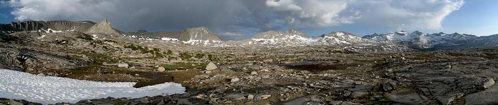
 Helen Lake and Mono Pass
 Route Map
The most common approaches to Mount Andrea Lawrence begin from either Tioga Pass Road in Yosemite or June Lake Loop in Inyo National Forest. The Mono/Parker Pass Trailhead in Yosemite is the shortest option, though many parties will begin in Lyell Canyon or via Rush Creek and ascend from the John Muir Trail.
Mono/Parker Pass Trail (37.89079° N, 119.26236° W)
From either the east or the west, follow Highway 120 to Yosemite National Park directly to the trailhead (1.4 miles west of Tioga Pass and 5.6 miles east of Tuolumne Meadows Campground).
Lyell Canyon (37.87790° N, 119.33873° W)
Follow Highway 120 into Yosemite National Park until reaching Tuolumne Meadows Lodge Road near Lembert Dome (6 miles west of Tioga Pass and 0.5 miles east of Tuolumne Meadows Campground). Signs here mark the location of the wilderness permit ranger station. You can either park at the ranger station, or continue down the road another 0.4 miles to the large trailhead parking area on the left.
Rush Creek (37.78316° N, 119.12685° W)
From 395 between Lee Vining and Mammoth, turn west on Highway 158/June Lake Loop and continue to the large trailhead parking area opposite Silver Lake at the lake’s north end. The trailhead is located 8.7 miles from the 158/395 north junction and 7.1 miles from 395 if using the southern junction.
Routes
Though the approaches to Mount Andrea Lawrence are long, the scenery is outstanding and the views from the top are exceptional. The summit routes are generally class 2 and 3 and are very straightforward with no significant route finding required. The true summit is a large boulder at the north end of the highpoint area, but the best views can be found on the south summit.The Mono/Parker Pass Trailhead option is highly recommended, as it passes by Helen Lake and Kuna Creek Basin. Both are very scenic locales.
| Route | Distance | Gain | Description |
|---|---|---|---|
| Mono/Parker Pass Trail | 9.5 miles one-way | 3,700 feet +1,150 feet on return | While this is the shortest route, it also benefits from less traffic than the Lyell Canyon route, especially helpful if obtaining a wilderness permit. From the trailhead head south on a well maintained trail, keeping right at a junction to the end of the trail at Spillway Lake (4 miles from the trailhead). Continue cross-country to Helen Lake, and up the class 2 right side of the wide saddle southwest of the lake. After a brief sandy area the large basin north of Mount Andrea Lawrence comes into view. Travel is generally easy with large slabs, grassy areas, streams, and ample camping locations (Yosemite NP does not allow camping in the Parker Pass Creek drainage). From the basin ascend either the class 3 north ridge or the west ridge, also class 3. For the west ridge, climb large boulders from the Donohue/Andrea Lawrence saddle, keeping to the north side of the ridge. If desired, midway up it is possible to traverse further left to a shallow chute that is mostly class 2 (when the snow conditions in the basin are right, this chute can be taken directly). |
| Lyell Canyon | 13.0 miles one-way | 4,200 feet +200 feet on return | The description for this route includes heading over Donohue Peak prior to reaching Mount Andrea Lawrence. Leave Tuolumne Meadows and follow Lyell Canyon south for 10 miles to the footbridge crossing the Lyell Fork. Between here and the lake at 10,200 feet, leave the trail and continue cross country up class 2 slopes to Donohue Peak (alternatively you can follow the trail to Donohue Pass and ascend from there- add about 1 mile overall). From Donohue Peak, descend to the saddle with Mount Andrea Lawrence and then up the class 3 west ridge. The final 100 feet down to the saddle is class three, and can be bypassed by taking a more circuitous route to the north. Climb large boulders from the Donohue/Andrea Lawrence saddle, keeping to the north side of the ridge. If desired, midway up it is possible to traverse further left to a shallow chute that is mostly class 2. |
| Rush Creek | 10.2 miles one-way | 5,600 feet +600 feet on return | The easiest approach outside Yosemite begins as the Rush Creek Trailhead near Silver Lake. The trail climbs steeply as it approaches Agnew Lake, then levels out greatly for the next 5 (dusty) miles as it passes Gem Lake and Waugh Lake. Leave the trail and ascend north cross-country towards Lost Lakes after reaching the west end of Waugh Lake, 8 miles from the trailhead. The base of the class 2 southeast ridge begins at the most southwestern of the Lost Lakes. |
Red Tape
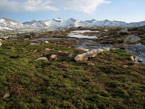 Mount Lyell and Mount Maclure from Kuna Creek Basin
Entrance Fees:
If beginning along Tioga Pass Road, the trailhead lies in Yosemite National Park and an entrance fee is required. The Yosemite fee page has full details. There are no entrance fees associated with the Rush Creek Trailhead.
Wilderness Permits:
Permits are required for overnight trips, but be aware that Yosemite has perhaps the worst permit pickup process in all of California. After hours pickup is not available, and if arriving in the morning expect to wait in line 1 ½ to 2 hours even with a reservation. Permits can be picked up at the Tuolumne Meadows Wilderness Center near the trailhead during open hours. Lyell Canyon is one of the most popular trailheads in Yosemite, and subject to quotas, so if seeking a permit reservations far in advance are highly recommended. Permits for Mono/Parker Pass a much easier to obtain. Check the Yosemite permit page for full details on hours, the reservation process, and reservation availability. Permits for trips using the Rush Creek Trailhead in Inyo National Forest can be picked up at the White Mountain Ranger Station in Bishop or the Mono Basin Visitor Center in Lee Vining. Quotas are in place May 1 through November 1. Check the Inyo National Forest wilderness permit website for the most current information and reservation availability.
Food Storage:
Bear canisters are required throughout Yosemite National Park and in this section of Inyo National Forest.
Campfires:
Fires are prohibited above 9,600 feet in Yosemite and above 10,000 feet in Inyo National Forest.
| Yosemite National Park Wilderness Permit Office PO Box 545 Yosemite, CA 95389 Phone: (209) 372-0740 Fax: (209) 372-0739 | Inyo National Forest Wilderness Permit Office 351 Pacu Lane, Suite 200 Bishop, CA 93514 Wilderness Information Line: (760) 873-2485 Permit Reservation Line: (760) 873-2483 |
When to Climb
Tioga pass is not plowed in the winter, and overnight parking is not permitted after October 15. As a result, spring through fall is the most realistic time for a visit. For a winter ascent the Rush Creek approach is the best option. In early season expect snow at the higher elevations.
 |
 |
 |
 |
 |
 |
Camping
 Camp in Kuna Creek Basin
Backcountry camping opportunities are abundant at the many lakes or streams encountered almost constantly on any route. Water sources and camping options are available as close as ½ mile from the summit.
Roadside camping is not permitted in Yosemite. Established Tuolumne Meadows Campground in Yosemite has just over 300 sites and is within walking distance of the Lyell Canyon trailhead. Reservations are recommended, though half of the sites are first-come, first-serve. There is also a walk-in backpackers’ camping area within the campground.
Inyo National Forest hosts a few first-come, first-serve campgrounds just east of the park near Tioga pass, and more numerous sites in Lee Vining Canyon. Those near Tioga pass tend to fill up quickly. There are also many camping options along June Lake Loop, including one at Silver Lake. The Inyo National Forest Camping page has further details. Dispersed camping is permitted throughout most of Inyo National Forest.
Etymology
On January 10, 2013, President Barack Obama signed the "Mt. Andrea Lawrence Designation Act of 2011" which had been introduced by California Democratic Senator Barbara Boxer and Santa Clarita Republican Congressman Buck McKeon, whose district stretches north to cover all of Mono and Inyo Counties.The act named Mount Andrea Lawrence in the Inyo National Forest and Yosemite National Park after Andrea Mead Lawrence, an Olympic gold medalist, conservationist, and former Mono County Supervisor.
A copy of Barbara Boxer's press release on the act with additional information follows:
Washington, D.C. – U.S. Senator Barbara Boxer (D-CA) today praised President Obama for signing her bill, the Mt. Andrea Lawrence Designation Act, into law. This legislation will name a mountain peak in Mono County “Mt. Andrea Lawrence” in honor of the renowned conservationist, three-time Olympian and former member of the Mono County Board of Supervisors who passed away in 2009. The bill passed the Senate by unanimous consent, and passed the House on a 408 to seven vote.
“I am so pleased that President Obama signed this bill honoring the life and contributions of one of Mono County’s most distinguished residents,” Senator Boxer said. “Andrea Lawrence dedicated her life to protecting the treasures of the Eastern Sierra. Her passion and achievements were larger than life, which is why I cannot think of a more fitting tribute than to name this majestic peak in her honor.”
Andrea Mead Lawrence was a three-time Olympian who remains the only American double Olympic gold medalist in alpine skiing. She was inducted into the U.S. National Ski Hall of Fame in 1958 at the age of 25, and in 2002, sports writer and documentary filmmaker Bud Greenspan called her “the greatest Winter Olympian of all time.”
Lawrence was also a committed conservationist who worked to protect and restore Mammoth Lakes, Mono Lake, Bodie State Historic Park and other important natural and cultural resources of the Eastern Sierra. She served for 16 years on the Mono County Board of Supervisors as well as on the Great Basin Air Pollution Control District and in 2003 founded the Andrea Lawrence Institute for Mountains and Rivers to promote environmental protection and economic vitality in the region.
Peak 12,240, previously identified only by its elevation, is located in Mono County near the Tuolumne County border. It is on the border of the Ansel Adams Wilderness, just east of Yosemite National Park. The John Muir trail passes close to the peak.
Senator Boxer and Congressman Buck McKeon (R-Santa Clarita) – who sponsored identical House legislation – first introduced the legislation during the 111th Congress. Supporters of this bill include Andrea Lawrence’s family, the Mono County Board of Supervisors, the Wilderness Society, the Sierra Club, the Mono County Democratic Central Committee, the Mammoth Town Council, the Mono Lake Committee, the Andrea Lawrence Institute for Mountains and Rivers, the Sierra Nevada Alliance, the Mammoth Mountain Ski Area, Town of Mammoth Lakes Council Member Wendy Sugimura and former Mono County Supervisor Tim Alpers.
