
-
 23339 Hits
-
 84.27% Score
-
 18 Votes
|
|
Mountain/Rock |
|---|---|
|
|
37.68990°N / 119.2907°W |
|
|
Hiking, Scrambling |
|
|
Summer, Fall |
|
|
12057 ft / 3675 m |
|
|
Overview
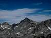
Along with nearby Electra Peak and Rodgers Peak, Foerster Peak is one of three SPS listed peaks that lie along the boundary separating southeastern Yosemite from the Ansel Adams Wilderness. If remoteness is defined as distance from the nearest road as the crow flies, Foerster Peak qualifies as relatively distant, lying over ten air miles from the nearest road. This is the most "remote" of the three by this metric, and one of the most "remote" such peaks in Yosemite--but perhaps somewhat surprisingly, the peak actually turns out to be the easiest of the three to reach, and is climbable as a very moderate dayhike from the south via the Isberg Pass trail.Foerster Peak lies at the head of Bench Canyon, just off Roper's Sierra High Route, and is--again somewhat surprisingly--frequently climbed by hikers following that route. The summit boasts some truly wonderful views of Maclure, Lyell, Rodgers, Banner, Ritter, and the Minarets, perhaps explaining its popularity.
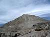
The peak's southeast slopes are class 2 from Blue Lake. The leftmost chute on the southwest face is class 2, with a short section of class 2-3 ledges on the righthand side to negotiate a headwall part way up; most of this chute is disagreeably loose, and a better ascent route is to climb either the more solid class 2-3 rock on the right side of the face or the south ridge. The south ridge and north ridge (west side) are both class 2-3.
Foerster Peak was first climbed in 1914 by a party led by none other than Norman Clyde, one of his earliest Sierra first ascents.
 |  |  |  |
Getting There
Foerster Peak is most easily reached out of the Isberg Pass trailhead. Follow the Isberg Pass trail for about ten miles, hiking past Sadler Lake to where Lower Isberg Lake first comes into view. Leave the trail here, and head north over gentle slabs and grass to a small saddle 1 mile north of Lower Isberg Lake. The north side of the saddle is equally easy; make a gradually descending traverse over slabs, talus, and grass to the small lake just northwest of Long Mountain, and from there descend the drainage that leads down to Harriet Lake. Hike east past an unnamed lake to a grassy gully, and follow this northeast up to the headwaters of Foerster Creek. The southwest face or south ridge are both easily climbed from here.It is also possible to traverse to the northeast from the ridge, avoiding the elevation loss to Harriet Lake, but some cliffs and many boulders are encountered when doing this; some elevation loss is unavoidable, and it ends up being faster to just drop down to easier ground. A crossing of the ridge in the vicinity of Long Mountain would be more direct and may also be possible, but there are steep slabs and snow on the north side of the peak that could be problematic in early or late season. Another option to reach the saddle is to follow the ridge from Isberg Peak (class 2).
Variations: Harriet Lake can also be reached easily from the Isberg Pass trail by following Foerster Creek up from the trail. This seems to be the usual approach.
The peak has also been climbed out of Tuolumne Meadows (via Vogelsang Pass and the Isberg Pass trail), or from Devils Postpile (via Granite Stairway and Bench Canyon). Be forewarned that although the Isberg Pass trail is well maintained and in excellent shape, other trails in the area--notably the trail past Hemlock Crossing and up the North Fork of the San Joaquin River, used to approach Bench Canyon--are less heavily traveled and are reportedly quite difficult to follow in places.
Red Tape, Conditions, etc.
The usual wilderness red tape applies; a permit is required for overnight visitors, and campfires are prohibited above 10,000 feet. Due to overuse, camping is prohibited within the immediate vicinity of several of the lakes along the Isberg Pass, including Cora Lakes and Sadler Lake; please obey the posted regulations at these lakes.Permits are obtained through Sierra National Forest for an approach via Isberg Pass (the permit can be picked up in Oakhurst or the Clover Meadow Ranger Station), Yosemite for an approach out of Tuolumne Meadows, or Inyo National Forest for an approach out of Devils Postpile.
For more information on red tape and conditions, please refer to the Tuolumne Meadows and Eastern Sierra logistical pages.
When To Climb
Like most High Sierra peaks, because of road closures and an awfully long approach in winter and spring, Foerster Peak is most easily climbed in the summer months, typically June through October in most years.Camping
Harriet Lake is a popular basecamp for climbs of the peak. The Isberg Lakes are also a popular camping area. |
Etymology
"[The peak] was named in 1895 by Lt. N. F. McClure for Lewis Foerster (1868-1936), a soldier and mountaineer, and a native of Germany: 'His service was outstanding, and it was in recognition of his achievements and because of his close association with the particular region that I gave his name to a prominent peak.' (SCB 22:102)"- Erwin Gudde, California Place Names
"In later years Benson and McClure, then colonels, were wont to extol the virtues of some of their men, in particular, Arndt, Fernandez, Foerster, Isberg, for whom various features of the park are named."
- Francis Farquhar, History of the Sierra Nevada