-
 13150 Hits
-
 88.19% Score
-
 26 Votes
|
|
Mountain/Rock |
|---|---|
|
|
38.67225°N / 78.27345°W |
|
|
Hiking, Bouldering, Scrambling |
|
|
Spring, Fall, Winter |
|
|
2468 ft / 752 m |
|
|

Cool crack...
Overview
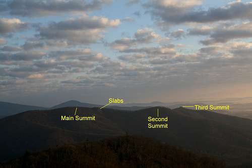
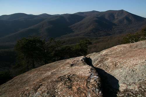
Reaching the summit of Oventop Mountain is not that exciting an affair-- it is some rock on a tree-covered mountain-- but the mountain has three nice features along the ridges northeast of the summit: a nice outcrop almost as high as the main summit and with nice views, some open granite slabs that also yield very nice views, and a rocky outcrop atop the lowest and northeasternmost summit that offers some surpisingly challenging scrambling.
The slabs are easily seen from the Buck Hollow Overlook on Skyline Drive. The rocks atop the third summit are also visible from the overlook, and the blocky top they lend to the summit draws attention as you approach Sperryville along U.S. 211.
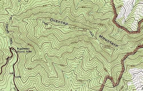
The Thornton Gap USGS quad shows a trail going along the ridges and connecting the three summits, but that trail is no longer maintained, though it is easy to find and follow in many places, meaning the mountain sees very little human traffic. People looking for solitude and who don't mind some easy bushwhacking will enjoy this peak quite a bit.
Getting There
On U.S. 211 between Sperryville and the Thornton Gap entrance to Skyline Drive, about 2 miles east of the entrance, look for a concrete post marked for Pass Mountain. This post is on the north side of the road and is by a sharp bend. There is room for two cars to park by the post. If the spaces are taken, park just down the road, on the other side, in a larger parking area.
Route Information
Distance to main summit: 1.8 mi, with about 1100' of elevation gain.
Distance to third summit: 3 miles, losing about 300' in all from the main summit to the third one, which makes the round-trip climb about 1500'.
Hike 0.6 mi up Pass Mountain Trail, gaining about 400' of elevation. When the trail reaches a saddle and bends sharply left (some posts make sure you see the trail's direction), leave the trail and head to your right up the ridge. Look for the old trail, which apparently still sees enough use to keep it from becoming totally overgrown. The trail, which disappears from time to time, climbs to the main summit, then goes just to the left of the second summit (a pile of rocks with no unobstructed views) and finally reaches the third summit, though Class 3 or 4 scrambling will be necessary to get atop the rocks there. When the trail does fade out, don't worry too much; first, the route along the ridge is obvious, and second, the bushwhacking on this peak is delightfully easy and hardly qualifies as bushwhacking at all (this may not be the case late spring through early fall, though).
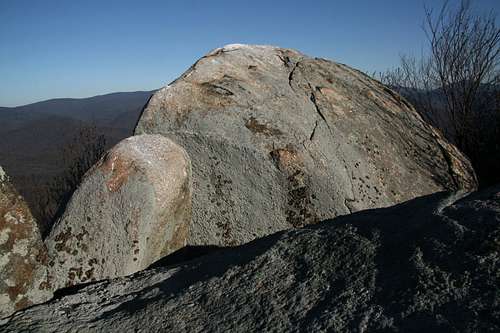
You reach the main summit after about a mile of hiking and 700' of elevation gain. If peakbagging is all you're after, you're done now and can head back. But if you've come for solitude, discovery, and views, keep going. Not far past the main summit, the trail descends slightly and passes some rocks (the rocks are to the left of the trail). Scramble up these rocks, which are almost as high as the main summit, for excellent views to the north of The Peak and Mount Marshall and southwest to Marys Rock.
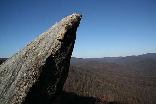
Soon after this, the trail descends some more, and some open slabs, the ones visible from Buck Hollow Overlook, are visible on the right. Head out to these slabs and enjoy scrambling or lounging on them as you take in the views south and southwest. If you are lucky enough to visit just after heavy rains, you may see an ephemeral waterfall, for I found dark water streaks on one of the faces and saw a small bit of ice in the shape of a water flow.
Continue down to a saddle between the main and second summit, and then head over the second summit to the third one. When you reach the summit area, you will encounter a jumble of boulders and blocks and have to find a way to scramble up them, where you will have outstanding views of the surrounding peaks and valleys. There is some good bouldering potential here, too. The tops of many of the rocks are stained white from buzzard droppings, clear evidence of how little human traffic there is here; you do not find such conditions in such abundance on Shenandoah's popular trail-accessible rock outcrops.
Elevation of second summit: 2303'
Elevation of third summit: 2245'
Red Tape
None-- many people think of Skyline Drive when they think of Shenandoah National Park, and there is an entrance fee for the road, but the trailhead described here, while within the park boundary, is not on Skyline Drive, and there are no trailhead fees like those at Old Rag Mountain and Whiteoak Canyon.
Camping
No developed sites close by. Backcountry camping is free, but you have to get a permit, meaning you will have to head up to the entrance station to fill one out.