
-
 33944 Hits
-
 78.27% Score
-
 9 Votes
|
|
Mountain/Rock |
|---|---|
|
|
32.44900°N / 111.489°W |
|
|
Pima |
|
|
Hiking |
|
|
Spring, Fall, Winter |
|
|
3907 ft / 1191 m |
|
|
Overview
Ragged Top is the craggy summit 25 miles northwest of Tucson and south of Picacho Peak and the Picacho Mountains. From I-10 it looks as if it would require ropes and some fancy routefinding to get to the top, but there is a class 2 gully on the north side that provides easy access through the summit cliffs. The climb is easily done in a few hours and makes for a nice half-day adventure. Climbing this peak in conjunction with Picacho Peak would make a nice day outing. Hiking the mountain is best in Spring, Fall, and Winter. Summers can be extremely hot. Watch for monsoon rains in summer (July) and early fall.Although this peak usually does not get much attention, it is a worthwhile climb because it is fairly remote and untraveled, but with a great summit feel. Despite its proximity to Tucson, most people don't even know its name or how to get there.
Ragged Top is part of the Ironwood Forest National Monument and the Silver Bell Mountains. Ironwood Forest National Monument was created in 2000 to protect the unique Desert Ironwood Tree (Olneya tesota) which is found only in the Sonoran Desert, and is in abundance around this peak. Ironwood Forest National Monument protects 129,000 acres and includes the Silver Bell, Waterman, and Sawtooth Mountains. The area extends from Casa Grande to Saguaro National Park, and borders the Tohono O'Odham Indian Reservation.
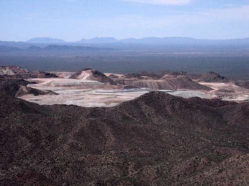
The ASARCO open pit copper mine to the west.
The mountain is also home to the last herd of indigenous Desert Bighorn Sheep in southeastern Arizona. Many hikers have seen these animals on their travels here. Please be respectful of their presence and do not disturb them if you see them! Also consider hiking the mountain at times other than the critical breeding season in August-September and lambing season in February. Other animals in the area include Javelina, Ferruginous Pygmy-Owl, and the Lesser Long-Nosed Bat. The latter two species are listed as endangered.
Ragged Top is composed of volcanic Miocene Rhyolite. This type of rock is associated with copper which can be found in the Silver Bell Mountains. Silver is also mined in the area. ASARCO owns an open pit copper mine to the west that is visible from the summit.
Getting There
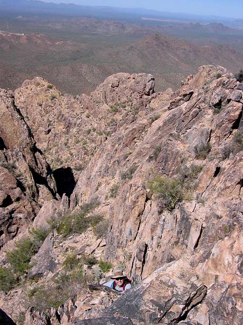
The final class 3 before the summit.
To get there without a 4-wheel drive, take I-10 west from Tucson and take Exit 236 at Sandario Road. Head left on Sandario Road, drive .1 mile, and then turn right onto Marana Road. Go almost 6 miles to Silverbell Road. Make a 'right' onto Silverbell Road. Keep following Silverbell Road 12.9 miles through the Monument to the parking area (5 miles of it is on dirt - thanks LLCoolBob for the mileage). The parking area is a dirt pull-out due north of Ragged Top marked by a rusty hard-to-see signpost on the left. If you miss the parking lot, you will reach Sasco road in about 1.8 miles. Turn around and go back to find the parking lot.
To get there with a 4-wheel drive, take I-10 west from Tucson to the Red Rock exit (quite near to Picacho Peak) and head southwest on Sasco Road for 13 miles. There are many agricultural fields in this area. You will need to ford the Santa Cruz River at some point...and sometimes it is full enough to even foil 4-wheel drives. Use caution. Once past the river keep driving until you are able to turn left at Silverbell. Drive about 1.8 miles to the rusty signpost on the right that marks the parking lot.
Red Tape
Ironwood Forest National Monument and Ragged Top are owned by BLM and there are no fees or permits required.Camping
Open camping is allowed in Ironwood Forest National Monument for up to 14 days. There are no facilities.There is also developed camping for $10/night at nearby Picacho Peak State Park. There are 95 first-come first-serve campsites with a maximum of a 15 night stay. If you want more luxury, there are 22 developed sites with RV hookups available at $15/night. Water, restroom, and showers are all available.
Of course, Tucson is so close you may want to make that your base of operation and find a nice hotel. Then you will be able to check out some of the other climbable peaks within several hours of Tucson.
Maps
The best map would be the 7.5 minute USGS map Silver Bell East (AZ).Links
Biological Survey of Ironwood Forest National MonumentAmerican Southwest Ironwood Forest National Monument Info
Arizona Desert Bighorn Sheep Society
LLCoolBob - Dec 30, 2016 7:40 pm - Hasn't voted
Driving directionsHi Hans, Thank you for the great page and route description. Could you please make two small additions to the driving directions. (1) Make a 'right' on Silverbell. It wasn't immediately obvious to this out of towner which way to turn. (2) Once you turn onto Silvebell, it's 12.9 miles total to the parking area, 5.0 miles on dirt. Hopefully this info will make it a little easier to find the parking, especially if approaching before sunrise.
hans.schenk - Dec 31, 2016 2:39 pm - Hasn't voted
Re: Driving directionsThanks so much! I have made the changes! Cheers!