
-
 13718 Hits
-
 84.27% Score
-
 18 Votes
|
|
Mountain/Rock |
|---|---|
|
|
31.70520°N / 110.9455°W |
|
|
Santa Cruz |
|
|
Hiking, Scrambling |
|
|
Spring, Fall, Winter |
|
|
5139 ft / 1566 m |
|
|
Overview
"Little Elephant Head" From the south
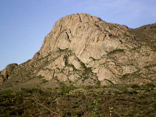
On the lower western slopes of the Santa Rita Mountains, between Aqua Caliente Canyon to the south and Chino Canyon toward the north, rises the unofficially named “Little Elephant Head.” As the morning sun rises, “Little Elephant Head” hides in the shadows of much higher neighbors Mounts Wrightson and Hopkins. But when the afternoon’s glow bathes “Little Elephant Head” and neighboring Elephant Head in warm orange light, these lower desert peaks become the stars of the show.
Distinctive to motorists along I-19 and to residents of Green Valley, “Little Elephant Head” makes for more than just pleasant scenery. Its rocky, exposed summit dishes up non-stop views and the rugged use-path to its summit provides neat, easy scrambling for folks of all ages and experience levels, to take them a step beyond the tedium of “the trail.” Deep canyons cut the western slopes of the Santa Ritas, making for especially dramatic views from the sheer drop-offs surrounding the summit of “Little Elephant Head.”
Rank: 2998th highest mountain in Arizona
Prominence: 439 feet
USGS Quad: Mount Hopkins
Rank & Prominence: Lists of John
Getting There

Ocatillo close-up

Ocatillo and Prickly Pear

Baboquivari Ghost

Purple Prickly Pear

Elephant Head and "Little Elephant Head" from Green Valley

"Little Elephant Head" from Green Valley
“Little Elephant Head” sits less than one hour south of Tucson, Arizona via I-19 and about 20 minutes from Green Valley, Arizona. There are two primary trailheads most folks visiting “Little Elephant Head” would utilize:
Southern Approach: Aqua Caliente Canyon
Though high-clearance is recommended for this route, it is passable in dry conditions for 2-wheel drive vehicles.
•I-19 to Exit 56 (Canoa Road)
•Under highway toward the east utilizing a roundabout
•Right (south) on Frontage Road for 3 miles to Elephant Head Road. Turn left.
•Cross the Santa Cruz River (usually dry)
•Right on Mount Hopkins Road (paved) for 5.5 miles to sign: Aqua Caliente Canyon KMSB.”
•Turn left on a dirt Forest Service road FS 183.
•Follow FS 183 for 2.5 miles. Park in pullout on right before road makes sharp left turn across wash with “Dead End” sign.
Northern Approach: Chino Canyon
High clearance 4x4s recommended.
•I-19 to Exit 56 (Canoa Road)
•Under highway toward east (roundabout?)
•Right (south) on Frontage Road for 3 miles to Elephant Head Road. Turn left.
•Follow Elephant Head Road to Hawk Road and turn right.
•Follow Hawk road to its end
•Go through the gate, where the road becomes increasingly rough, requiring a high clearance 4x4 drive.
•Continue on the dirt road to the junction with FS 4073. Follow FS 4073 down through a wash and through another gate.
•Look for a sign to Madera Canyon and Chino Canyon, and follow the road to Chino Canyon.
Red Tape & Special Cautions
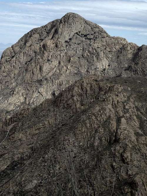
Elephant Head from "Little Elephant Head"
There are no fees to access this part of the Coronado National Forest and very few regulations. “Little Elephant Head” sits outside of the Mount Wrightson Wilderness Area.
Take note, however, than “Little Elephant Head” sits only 26 miles as the raven flies north of the US-Mexico border. There is a lot of illicit traffic in this border region (La Frontera), and as evidenced by discarded clothing, food wrappers, water containers, backpacks and whatever other refuse, the canyons and trails around “Little Elephant Head” see their fair share of traffic. Your average migrant likely poses little threat, but traffickers in drugs, weapons or people (los coyotes) are an entirely different matter. Visiting “Little Elephant Head” before sunrise or after sunset cannot be recommended. Travel in larger groups (not solo) is suggested. Trust you gut, keep your eyes open and mind your own business.

"Little Elephant Head" from Elephant Head
Camping & Lodging

Elephant Head rises over Chino Canyon

Elephant Head and "Little Elephant Head" from the south
While rustic camping can surely be had near the base of this peak, I do not recommend it for reasons of personal safety. Head instead up Madera Canyon to the Bogs Spring Campground, operated by the US Forest Service.
The Bogs Spring Campground, operated by Coronado National Forest, is the nearest camping on the west-side of the peak.
•13 campsites with tables and fire grills
•Drinking water available
•Toilets
•Paved access road
•Elevation: 5,200'
•Season: Year-round
Hotels: The nearby retirement community of Green Valley provides several standard national chain hotels.
Weather & Seasons
 | This is a great peak to visit in winter. Summer would be dreadfully hot. Spring and fall may be nice, depending on the weather pattern. |  |
 Summit Ammo Can |  East toward Mt. Hopkins |  Summit |