
-
 20569 Hits
-
 85.36% Score
-
 20 Votes
|
|
Mountain/Rock |
|---|---|
|
|
46.99690°N / 13.28780°E |
|
|
Mountaineering, Scrambling, Skiing |
|
|
Spring, Summer, Fall |
|
|
10124 ft / 3086 m |
|
|
Overview
What's New On This Page?
> NOV 25th, 2022 - Interactive map embedded.
> FEB 6th, 2013 - SP V3 design updates.
> JAN 8th, 2009 - Pictures attached/detached.
> FEB 13th, 2005 - The 'Summit Views' chapter added and pictures attached/detached.
Saeuleck Presented
Saeuleck (Säuleck) is one of four most important peaks of the Ankogel Group. Because of its easy access, It is often referred as a Damen-3000er. (As Mathias Zehring says: "It is perhaps interesting that this old prejudice has been published by a lady, the Austrian author Liselotte Buchenauer".) From its top it's also possible to ski towards Doesenertal.
With the highest peak of this group, Hochalmspitze, Säuleck is connected by a long ridge (Detmolder Grat), where also a demanding marked route leads. Saeuleck's north slopes fall deeply down (more than 1000 m) in Seebachtal (or its end Winkeltal), the eastern and southern slopes are not so high. From it's peak a long ridge branches towards the west (to Maresenspitzen), while the main ridge continues from Hochalmspitze over Säuleck towards the south, where the Ankogel Group connects to the Reisseck Group.
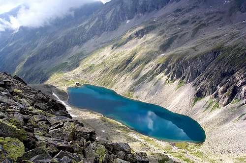
Saeuleck is often ascended. It takes you a full one day hike, only near the top you will have to scramble a bit. Marked routes arrive from the SW through Doesenertal and from the SE through Gössgraben, connecting on Mallnitzer Scharte (pass).


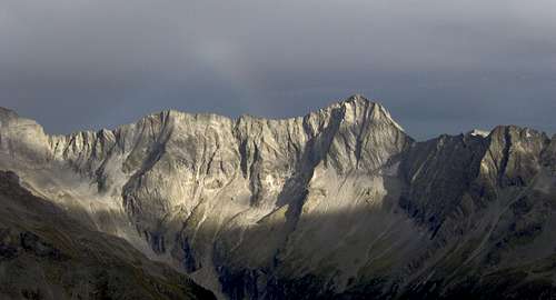
Summit Views
 The view on Ankogel |


Getting There
The Western Approach:
You follow the valley of river Drau to Obervellach, where you turn north towards the well known tourist resort Mallnitz (1190 m). If you're by car, you turn just before Mallnitz right in Doesenertal and drive till the point where the road is closed (cca 1450 m). From there to the summit you will need ca. 5 hours.
The Eastern Approach:
You leave A10 highway (Salzburg-Villach) in Gmuend, where you enter the Malta valley. You drive through Malta till Koschach, where you turn westwards into the Gössgraben. From the end of the road you'll need to the peak ca. 4-5 hours.
The Northern Approach
(Contributed by Mathias Zehring):
Mallnitz can be reached from the north (especally from Germany) via Salzburg - Bischofshofen - Badgastein and then through the railway tunnel that carries also cars. Because this is an important railway route, the apprach can very well be done by train. You can hire a taxi in Mallnitz that brings you into the Doessener Tal valley.
You can see a detailed map on: http://www.austrianmap.at/. Even more useful is the below online map - explore it!
 |
 |
Routes List
Many marked routes are reaching the summit of Saeuleck. Among them is also a new, demanding ferrata, which has in addition to difficult secured passages also a few climbing passages of UIAA degree II.
- Normal approach from the SW (from the Arthur-von-Schmid-Haus). Not demanding hike-up, 2 h 30 min. Also a wonderful, but from the parking place or train station very long tour (with return).
- Buderus Weg (The eastern approach). Hike-up, with one secured place (the ravine to Mallnitz notch) to be climbed. 3 h. From the parking place very long tour (with return).
- Detmolder Weg. The route is usually done when connecting in a long tour the summits of Saeuleck and Hochalmspitze. The approach is from the eastern side and then by the NE ridge (Detmoldergrat) on the summit. Easy climb and ferrata. From the Gießener Hütte over Schneewinkelspitze 5 h 30 min. It's also possible to gain the Detmolder ridge on the Winkelscharte, 2856 m, coming up from the NW. This is the so-called Celler Weg (coming from Celler hut).
- Naturnaher Klettersteig (Saeuleck ferrata). This is a new, demanding ferrata, which was constructed in 2007. On the Austrian 6-point scale (A-F) it id rated D/E, with a few climbing details of degree 2. The ascent goes from Arthur-von-Schmid-Haus and then along the exposed S ridge on the western fore-summit and by the ridge on the highest point. See the description in German here. (Thanks to Mathias Zehring for info.)
Red Tape
No limitations.
When To Climb
Saeuleck is accessible the whole year, although the best months for climbing would be July to October. In winter conditions you should come with skis, but if you don't ski, you'll need some winter equipment, especially if snow is hard or slopes are icy.
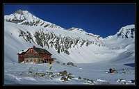
Camping
Arthur-von-Schmid-Haus (2281 m). In case you don't want to climb Saeuleck in one day this is the best base for west approach.
Credit for this information to SP member: seba_mallnitz
Date: Nov 08, 2003 08:40 AM
- 2,281 m. above sealevel in Mallnitz.
- Opened from the beginning of June till 10 October.
- 25 beds, 46 lager, 30 notlager
- Winterroom opened, 15beds, Skitours only possible in the beginning of the year.
- Mobile telephonenumber: 0043-06 64-112 28 27
- Owner: ÖAV Sektion Graz St. G. V., A-8010 Graz, Sackstrasse 16
Tel.: 00 43-316 82 22 66
E-mail= graz@sektion.alpenverein.at
- Host: Johann Fleissner, A-9822 Mallnitz
Giessener Huette (2202 m. In case you don't want to climb Saeuleck in one day this is the best base for east approach.
Credit for this information to SP member: seba_mallnitz
Date: Nov 08, 2003 08:41 AM
- 2,202 m. above sealevel in Malta/Gmünd.
- Opened from the beginning of July till the end of September
- 24 beds, 42 lager, 34 notlager, 12 lager in Winterroom
- Owner: DAV Sektion Giessen-Oberhessen e. V., Schillerstrasse 34, D- 3530 Giessen.
Tel.: D-06 41- 39 05 12
Fax: D-0641- 301 14 68
E-mail: dav-giessen@t-online.de
Internet: http://home.t-online.de/home/dav-giessen.de
- Host: Otmar Baier, Brandstatt 13, A-9854 Malta.
Tel. hut: 0043 - 6 63-914 80 24
 |
Vid Pogachnik - Sep 13, 2004 8:16 am - Hasn't voted
Untitled CommentThat would be normal. But you climbed to the top of Saeuleck over Schneewinkelspitze. 5,5h is OK - I can add this info to the east approach.
But my original information says, that you can reach Saeuleck from east (from the parking place) in 4 hours. You don't need to go over Schneewinkelspitze, but you can climb over Mallnitzer Scharte. It's more direct and easier (but I didn't go there) and probably can be done in 4h.
Bor - Sep 13, 2004 10:42 am - Voted 10/10
Untitled CommentYes I agree..we desended there but my mother went there up and I think she was walking around 5 hours. We descended there then together and we were walking around 3 hours.
For information! =)
Chears Bor!
Christoph De Windt - Sep 13, 2004 10:46 am - Voted 10/10
Untitled CommentHey guys,
A view years ago I did this trip, starting in Arthur v. Schmid-Haus over Grosser Gösspitze to Saüleck and Schneewinkelspitze and from there to Geissenerhütte and I did need 10 hours to do that. The next day I went to the Hannoverhaus.
Bor - Sep 12, 2004 3:34 pm - Voted 10/10
Untitled CommentVid I must correct you something!
For the east approach over Detmolder Weg we walked about 5,5 hours and we were quick. Because the ridge from Schneewinkelspitze to the Saeuleck is very long nad has a lot of ascends and descends!
Chears Bor!
Vid Pogachnik - Sep 13, 2004 8:16 am - Hasn't voted
Untitled CommentThat would be normal. But you climbed to the top of Saeuleck over Schneewinkelspitze. 5,5h is OK - I can add this info to the east approach.
But my original information says, that you can reach Saeuleck from east (from the parking place) in 4 hours. You don't need to go over Schneewinkelspitze, but you can climb over Mallnitzer Scharte. It's more direct and easier (but I didn't go there) and probably can be done in 4h.
Bor - Sep 13, 2004 10:42 am - Voted 10/10
Untitled CommentYes I agree..we desended there but my mother went there up and I think she was walking around 5 hours. We descended there then together and we were walking around 3 hours.
For information! =)
Chears Bor!
Christoph De Windt - Sep 13, 2004 10:46 am - Voted 10/10
Untitled CommentHey guys,
A view years ago I did this trip, starting in Arthur v. Schmid-Haus over Grosser Gösspitze to Saüleck and Schneewinkelspitze and from there to Geissenerhütte and I did need 10 hours to do that. The next day I went to the Hannoverhaus.
Mathias Zehring - Aug 9, 2009 5:34 pm - Voted 10/10
new ferrataIn 2008 a new via ferrata has been built. It is a long and difficult one - rated D on the austrian A-E-scale description in german
Vid Pogachnik - Aug 10, 2009 3:55 am - Hasn't voted
Re: new ferrataThank you, mathias! I put basic info and the link on the page of Saeuleck. Cheers! Vid