
-
 8318 Hits
-
 83.1% Score
-
 16 Votes
|
|
Mountain/Rock |
|---|---|
|
|
39.12180°N / 104.9295°W |
|
|
El Paso |
|
|
Hiking |
|
|
Spring, Summer, Fall, Winter |
|
|
8255 ft / 2516 m |
|
|
Overview
 Britton Scullcap (Scutllaria brittonii) dance in the breeze on the summit of Sundance Mountain B.
31 May 2008
Profile photo courtesy of SP member cftbq
Colorado Rank: Unranked
Prominence: Approximately 110 feet
USGS Quad: Palmer Lake
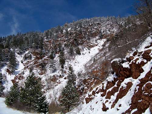
Shyly rising behind the community collectively known as Palmer Lake sits a quiet little mountain with a lovely name. Sundance Mountain climbs to 8,255 feet on the western horizon, standing guard with fellow unranked 8er Chautauqua Mountain at the mouth of a deep valley. In this valley Ice Cave Creek and North Monument Creek converge to form Monument Creek. Sundance Mountain B makes a pleasant half-day excursion for residence of or visitors to northern Colorado Springs.
Though no trail to the summit of Sundance Mountain B officially appears on any map consulted, not even the venerable Pikes Peak Atlas, social trails cut by thousands of local footsteps provide a relatively smooth ride to the summit of this gentle peak. While the grassy, sparsely-treed summit of Sundance Mountain B may fail to inspire, the views of afforded from the top will not disappoint. Views to the east include the communities Palmer Lake and Monument and Ben Lomand Mountain (7,636 ft.). To the south, in order, the hiker sees Raspberry Mountain (8,650 ft.) and a very unique view of Mount Herman (9,063 ft.) To the southwest sits the reliable presence of Pikes Peak (14,115 ft.) with loyal companion Almagre Mountain (12,367 ft.) nearby.
Getting There
 Outcroppings in the Ice Cave Area
31 May 2008
- Follow Hwy 105 west (you will initially parallel I-25 northbound) through Monument to the town of Palmer Lake.
- Pass through Palmer Lake and the tiny town of Pine Crest.
- In the small town of Glen Park, turn left/west on Lower Glenway.
- Follow Lower Glenway until it dead-ends at Glenway Avenue and turn left/west.
- Park at the junction of Glenway Avenue and Highland Road. (There is no parking available west of this point.)
- Follow the dirt extension of Glenway Avenue west. Continue on the road, though you may feel like you are entering an area off limits.
- Soon you will encounter a gate with visitor use rules, etc. This is where the hike begins.
 Western Slope of Sundance Mountain
05 Apr 09
Red Tape
 Papilio polyxenes or Black Swallowtail on Sundance Mountain B
 31 May 2008
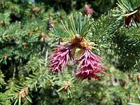 Female Springtime cones of the Rocky Mountain Douglas Fir on the summit of Sundance Mountain B.
31 May 2008
As noted in the Camping & Lodging section, a sign at the gate where Glenway Avenue ends expressly forbids camping in this valley as the valley contains reservoirs holding the Palmer Lake area water supply.
Dogs are to be leashed when hiking up the Monument Creek drainage. A sign indicates that this rule is “strictly enforced” to protect the water supply. During my visit to this area, a police officer was just departing upon our arrival. I suggest adhering to the wishes of the community and leashing your pet.
Camping & Lodging
 Erigeron flagellaris, commonly called Trailing Daisy, on the Sundance Mountain Summit.
31 May 2008
 Physocarpus monogynus, more commonly known as Ninebark, growing along Monument Creek.
31 May 2008
This access into the U.S. National Forest is accessible via a short drive from anywhere in the Colorado Springs metropolitan area. A visit to Sundance Mountain B is a short, pleasant day trip for hikers from Denver. As a result, lodging is unnecessary for a majority of visitors to Sundance Mountain B.
A sign at the gate where Glenway Avenue ends expressly forbids camping in this valley as the valley contains reservoirs holding the Palmer Lake area water supply.
Weather & Seasons
Sundance Mountain B can be hiked year-round. Relative to other Colorado mountains, the Rampart Range receives relatively little snow, especially in the lower reaches. However, after a big snow fall, Sundance Mountain B would make for a delightful snowshoe in the winter. In the summer, temperatures in the Rampart Range can be much hotter than in the high country of Colorado. Bring plenty of water and protection from the sun.External Links
Pike & San Isabel National ForestsPike National Forest Recreation Map
 An unusual view of Mount Herman (9,053 ft.) to the south from the summit of Sundance Mountain B.
31 May 2008
Jeremy Hakes - Jul 25, 2008 10:07 am - Voted 10/10
Distance, gain.From my hike armed with GPS, I'd mention that this hike is about 4 miles long round trip with 1100' of gain when you follow the trail up and down. FYI.
Sarah Simon - Jul 25, 2008 11:21 am - Hasn't voted
Re: Distance, gain.Jeremy, Thanks for the note. Since there are typically many ways up a mountain, I've come to avoid any reference to trail mileage/gain on the actual mountain page. Take a look at the route page I posted for this peak, though. http://www.summitpost.org/route/411635/monument-creek-route.html The way I went, both GPS and map indicate Approximate Roundtrip Mileage: 2.25 miles Approximate Elevation Gain: 1,000 feet Is is possible you took another route than we did? If so, maybe your route could be posted as "Monument Creek Route -- Variation". ??? Sarah
Jeremy Hakes - Jul 25, 2008 11:29 am - Voted 10/10
Re: Distance, gain.Sarah - I believe I went further up the creek to the saddle farther north. I added a photo/topo map to the page. A bit longer, but a little more gentle ascent following the drainage. Pretty, though! :)