
-
 8510 Hits
-
 83.1% Score
-
 16 Votes
|
|
Mountain/Rock |
|---|---|
|
|
44.93840°N / 108.28167°W |
|
|
Big Horn |
|
|
Hiking, Scrambling |
|
|
Spring, Summer, Fall, Winter |
|
|
4618 ft / 1408 m |
|
|
Overview
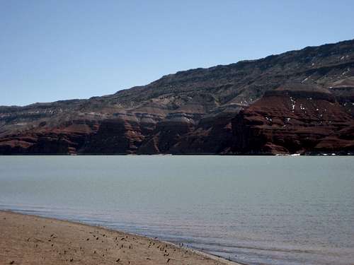 Northeast face over Yellowtail Reservoir
Sykes Mountain sits on the southern end of the beautiful Bighorn Canyon National Recreation Area near the northern end of the Big Horn Mountain Range. Its sheer northeast face overlooks Yellowtail Reservoir, and the views from the top of Big Horn Basin and the surrounding mountains are spectacular.
From far away, the mountain looks like a large pile of reddish rocks dotted with green bushes. However, upon closer inspection, you will discover that it is made up of a fascinating mix of multi-hued rocks, giant boulders, massive rock slabs, and short alien trees that make for a fun scrambling experience. If you hike on this mountain when it is warm, be wary of rattlesnakes, as this area can be literally crawling with them!
Sykes Mountain is named after Frank Sykes, who was a very colorful and eccentric early settler of the area. The legends and tall tales surrounding this man and his wife are absolutely wild; visit this site to read more.
Getting There
 Terrain near the summit
 Summit view southeast
From Lovell, Wyoming, follow Highway 14A east of town for about 2.5 miles, at which point you will see a sign directing you to turn left to go to Bighorn Canyon. After following this road for 8.0 miles, look for a road that turns right and heads over a cattle guard through an opening in the fence. Turn here and park just inside the fence, where you will begin the hike towards the mountain, the base of which is a quarter of a mile away.
The entire route to the summit is a steep Class 2 scramble that weaves around an assortment of small ridges and scattered rocks. There are really no dead ends here and just about any route you take will eventually get you to the top. Much of the hike is done on the large rock slabs that cover the mountain. The Crooked Point survey marker is located on one of the boulders at the summit, along with the broken down remains of a what was once a wood cross.
 Summit marker
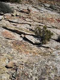 Rock slabs
Reaching the summit of Sykes Mountain via this route entails a Class 2 hike of 1.0 mile and 600 feet of elevation gain.
For a more scenic and established hike, enter the Recreation Area and look for the Sykes Mountain Trail on the right immediately after the fee area. This trail takes you up the north side of the mountain and runs along the cliffs on the northeast side of the mountain, providing amazing views of the Reservoir. The trail makes a large circle on the top of the mountain, and a short trip off of the trail to reach the summit is fairly easily done. The total distance is listed 3.75 miles at the trailhead; the hike is described in more detail on page 102 of the second edition of Bill Hunger's book Hiking Wyoming, published by Falcon Guides.
 Typical scenery
Red Tape
If you decide to climb this peak via the Sykes Mountain Trail, you will have to pay a $5 fee to enter the Big Horn Canyon National Recreation Area, or you can buy a full year pass for $30. The Interagency Annual Pass will also get you in.There are signs in the park warning of rattlesnakes, as there are lots of them around, so keep an eye out for them!